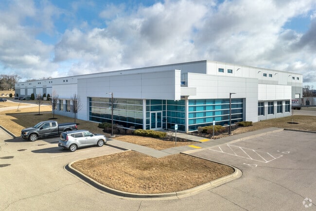
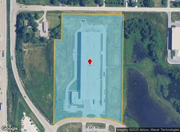
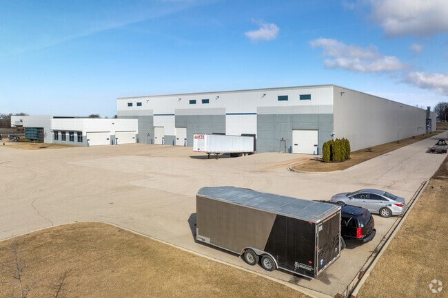
Property Record
13448 Deback Ln, Caledonia, WI 53126
NEARBY LISTINGS FOR SALE OR LEASE
Property Detail
13448 Deback Ln
Racine, WI
Certified Survey Map No 3219
104-042230015100
PT NW1/4CSM 3219 V105 PG574LOT 1 FROM 104042230020003 IN 2016 FOR 2017 ROLL **TOTAL ACRES** 15.37
Industrialgeneral
Racine
X
Wisconsin
55101C0087D
15.37 AC
2024
Racine East
2024
Milwaukee/Madison
001601
DEMOGRAPHICS near 13448 Deback Ln
1 Mile
3 Mile
5 Mile
2024 Total Population
329
3,800
15,246
2029 Population
320
3,726
15,047
Pop Growth 2024-2029
(2.74%)
(1.95%)
(1.31%)
Average Age
46
43
43
2024 Total Households
134
1,498
6,000
HH Growth 2024-2029
(2.99%)
(2.07%)
(1.28%)
Median Household Inc
$114,285
$105,886
$102,434
Avg Household Size
2.40
2.50
2.50
2024 Avg HH Vehicles
3.00
3.00
2.00
Median Home Value
$344,594
$332,243
$330,354
Median Year Built
1966
1968
1979
Nearby Places
Map Layers
Map Styles
 Street
 Aerial
- Restaurants
- Banks
- Shops
- Fitness
- Groceries
PUBLIC TRANSPORTATION
COMMUTER RAIL
Sturtevant Amtrak Station (Hiawatha Service - Amtrak)
DRIVE
WALK
Distance
Sturtevant Amtrak Station (Hiawatha Service - Amtrak)
12 min
7.0 mi
AIRPORT
General Mitchell International
DRIVE
WALK
Distance
General Mitchell International
19 min
14.1 mi
Freight Ports
Port Milwaukee
DRIVE
WALK
Distance
Port Milwaukee
24 min
18.0 mi
Nearby Properties
Address
Land Use
TOTAL SIZE
Lot Size
Zoning
Address
Land Use
TOTAL SIZE
Lot Size
Zoning
32.09 AC
Address
Land Use
TOTAL SIZE
Lot Size
Zoning
23.32 AC
Address
Land Use
TOTAL SIZE
Lot Size
Zoning
21.59 AC
Address
Land Use
TOTAL SIZE
Lot Size
Zoning
21.59 AC
Address
Land Use
TOTAL SIZE
Lot Size
Zoning
9.76 AC
Address
Land Use
TOTAL SIZE
Lot Size
Zoning
9.76 AC
Address
Land Use
TOTAL SIZE
Lot Size
Zoning
11.74 AC
Address
Land Use
TOTAL SIZE
Lot Size
Zoning
27.70 AC
Address
Land Use
TOTAL SIZE
Lot Size
Zoning
39.67 AC
Address
Land Use
TOTAL SIZE
Lot Size
Zoning
Address
Land Use
TOTAL SIZE
Lot Size
Zoning
3.54 AC
Address
Land Use
TOTAL SIZE
Lot Size
Zoning
Address
Land Use
TOTAL SIZE
Lot Size
Zoning
Address
Land Use
TOTAL SIZE
Lot Size
Zoning
32.28 AC
Address
Land Use
TOTAL SIZE
Lot Size
Zoning
Address
Land Use
TOTAL SIZE
Lot Size
Zoning
11.72 AC
Address
Land Use
TOTAL SIZE
Lot Size
Zoning
Address
Land Use
TOTAL SIZE
Lot Size
Zoning
4.96 AC
Address
Land Use
TOTAL SIZE
Lot Size
Zoning
Address
Land Use
TOTAL SIZE
Lot Size
Zoning
39.85 AC
Address
Land Use
TOTAL SIZE
Lot Size
Zoning
13.69 AC
Address
Land Use
TOTAL SIZE
Lot Size
Zoning
6.38 AC
Address
Land Use
TOTAL SIZE
Lot Size
Zoning
Address
Land Use
TOTAL SIZE
Lot Size
Zoning
Address
Land Use
TOTAL SIZE
Lot Size
Zoning
Address
Land Use
TOTAL SIZE
Lot Size
Zoning
Address
Land Use
TOTAL SIZE
Lot Size
Zoning
2.66 AC
Address
Land Use
TOTAL SIZE
Lot Size
Zoning
19.13 AC
Address
Land Use
TOTAL SIZE
Lot Size
Zoning
3.66 AC
The World's #1 Commercial Real Estate Marketplace
Connect with us
© 2026 CoStar Group
The information above has been obtained from sources believed reliable. While we do not doubt its accuracy we have not verified it and make no guarantee, warranty or representation about it. It is your responsibility to independently confirm its accuracy and completeness. Any projections, opinions, assumptions, or estimates used are for example only and do not represent the current or future performance of the property. The value of this transaction to you depends on tax and other factors which should be evaluated by your tax, financial, and legal advisors. You and your advisors should conduct a careful, independent investigation of the property to determine to your satisfaction the suitability of the property for your needs.