Property Record
1345 E Glendale Ave, Sparks, NV 89431


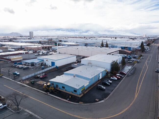
Property Detail
1345 E Glendale Ave
034-263-11
FR NW4 SE4 SEC 10 TWP 19 RGE 20
Industrialgeneral
Washoe
I
Nevada
AE The base floodplain where base flood elevations are provided. AE Zones are now used on new format FIRMs instead of A1-A30 Zones.
1 AC
2025
Sparks
2026
Reno/Sparks
003111
Reno, NV
17,888 SF
NEARBY LISTINGS FOR SALE OR LEASE
DEMOGRAPHICS near 1345 E Glendale Ave
1 mile
3 mile
5 mile
2025 Total Population
4,840
62,904
174,131
2030 Population
5,081
64,205
178,397
Pop Growth 2025-2030
+ 4.98%
+ 2.07%
+ 2.45%
Average Age
38
40
39
2025 Total Households
2,399
25,034
69,145
HH Growth 2025-2030
+ 5.46%
+ 2.33%
+ 2.61%
Median Household Inc
$66,047
$80,769
$67,799
Avg Household Size
1.90
2.40
2.40
2025 Avg HH Vehicles
1.00
2.00
2.00
Median Home Value
$404,878
$441,337
$429,275
Median Year Built
1987
1982
1983
Nearby Places
Map Layers
Map Styles
 Street
 Aerial
Transit
 Traffic
 Biking
Places
Listings with unknown addresses are not visible on the map
- Restaurants
- Banks
- Shops
- Fitness
- Groceries
PUBLIC TRANSPORTATION
COMMUTER RAIL
Drive
Walk
Distance
11 min
6.4 mi
AIRPORT
Reno/Tahoe International
Drive
Walk
Distance
Reno/Tahoe International
9 min
3.9 mi
SALE & LEASE HISTORY
LISTING DATE
SALE/LEASE

Dec 28, 2021
For Lease
Nearby Properties
Address
Land Use
TOTAL SIZE
Lot Size
Zoning
Address
Land Use
TOTAL SIZE
Lot Size
Zoning
385,812 SF
16.47 AC
NUD
Address
Land Use
TOTAL SIZE
Lot Size
Zoning
991,800 SF
51.03 AC
PD
Address
Land Use
TOTAL SIZE
Lot Size
Zoning
6,641 SF
247.42 AC
PF
Address
Land Use
TOTAL SIZE
Lot Size
Zoning
296,048 SF
93.65 AC
PF
Address
Land Use
TOTAL SIZE
Lot Size
Zoning
356,160 SF
12.05 AC
MUD
Address
Land Use
TOTAL SIZE
Lot Size
Zoning
347,564 SF
10.23 AC
MUD
Address
Land Use
TOTAL SIZE
Lot Size
Zoning
365,962 SF
3.54 AC
PD
Address
Land Use
TOTAL SIZE
Lot Size
Zoning
617,081 SF
2.62 AC
MUD
Address
Land Use
TOTAL SIZE
Lot Size
Zoning
366,641 SF
37.91 AC
MA
Address
Land Use
TOTAL SIZE
Lot Size
Zoning
246,076 SF
16.43 AC
PD
Address
Land Use
TOTAL SIZE
Lot Size
Zoning
622,628 SF
2.91 AC
MUD
Address
Land Use
TOTAL SIZE
Lot Size
Zoning
79,748 SF
8.98 AC
NUD
Address
Land Use
TOTAL SIZE
Lot Size
Zoning
232,481 SF
9.45 AC
PD
Address
Land Use
TOTAL SIZE
Lot Size
Zoning
273,101 SF
15.96 AC
MF-3/PUD
Address
Land Use
TOTAL SIZE
Lot Size
Zoning
150,712 SF
16.90 AC
PO
Address
Land Use
TOTAL SIZE
Lot Size
Zoning
34,503 SF
30.82 AC
PF
Address
Land Use
TOTAL SIZE
Lot Size
Zoning
242,907 SF
4.18 AC
NUD
Address
Land Use
TOTAL SIZE
Lot Size
Zoning
203,367 SF
1 AC
MUD
Address
Land Use
TOTAL SIZE
Lot Size
Zoning
378.16 AC
GR
Address
Land Use
TOTAL SIZE
Lot Size
Zoning
1,269,958 SF
54.19 AC
I
Address
Land Use
TOTAL SIZE
Lot Size
Zoning
396,497 SF
20.80 AC
PD
Address
Land Use
TOTAL SIZE
Lot Size
Zoning
146,586 SF
2.94 AC
IC
Address
Land Use
TOTAL SIZE
Lot Size
Zoning
622,571 SF
25.69 AC
I
Address
Land Use
TOTAL SIZE
Lot Size
Zoning
133,992 SF
19.86 AC
TC
Address
Land Use
TOTAL SIZE
Lot Size
Zoning
84,778 SF
42.67 AC
MA
Address
Land Use
TOTAL SIZE
Lot Size
Zoning
136,331 SF
0.93 AC
MUD
Address
Land Use
TOTAL SIZE
Lot Size
Zoning
270,772 SF
32.96 AC
I
Address
Land Use
TOTAL SIZE
Lot Size
Zoning
173,181 SF
9.37 AC
IC
Address
Land Use
TOTAL SIZE
Lot Size
Zoning
127,618 SF
7.63 AC
I
Address
Land Use
TOTAL SIZE
Lot Size
Zoning
221,512 SF
15.32 AC
MUD
The World's #1 Commercial Real Estate Marketplace
Connect with us
© 2026 CoStar Group
The information above has been obtained from sources believed reliable. While we do not doubt its accuracy we have not verified it and make no guarantee, warranty or representation about it. It is your responsibility to independently confirm its accuracy and completeness. Any projections, opinions, assumptions, or estimates used are for example only and do not represent the current or future performance of the property. The value of this transaction to you depends on tax and other factors which should be evaluated by your tax, financial, and legal advisors. You and your advisors should conduct a careful, independent investigation of the property to determine to your satisfaction the suitability of the property for your needs.