Property Record
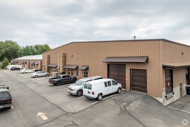
1345 E State St, Eagle, ID 83616

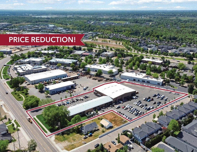
This Property Is For Sale
Current Lease Availabilities
Property Detail
1345 E State St
S0516110130
PAR #0130 OF NE4NE4 SEC 16 4N 1E #2190 R #8209372
Foundry
Ada
M-1
Idaho
B and X Area of moderate flood hazard, usually the area between the limits of the 100-year and 500-year floods.
2 AC
2024
Eagle
2025
Boise City/Nampa
010234
Boise City, ID
28,124 SF
NEARBY LISTINGS FOR SALE OR LEASE
DEMOGRAPHICS near 1345 E State St
1 mile
3 mile
5 mile
2024 Total Population
8,912
47,429
150,227
2029 Population
9,553
49,953
157,471
Pop Growth 2024-2029
+ 7.19%
+ 5.32%
+ 4.82%
Average Age
45
44
42
2024 Total Households
3,722
18,294
56,446
HH Growth 2024-2029
+ 7.66%
+ 5.80%
+ 5.24%
Median Household Inc
$85,399
$102,344
$99,277
Avg Household Size
2.40
2.50
2.60
2024 Avg HH Vehicles
2.00
2.00
2.00
Median Home Value
$668,379
$695,884
$588,792
Median Year Built
2003
1999
2000
Nearby Places
Map Layers
Map Styles
 Street
 Aerial
Transit
 Traffic
 Biking
Places
Listings with unknown addresses are not visible on the map
- Restaurants
- Banks
- Shops
- Fitness
- Groceries
PUBLIC TRANSPORTATION
AIRPORT
Boise Air Trml/Gowen Field
Drive
Walk
Distance
Boise Air Trml/Gowen Field
28 min
17.4 mi
Nearby Properties
Address
Land Use
TOTAL SIZE
Lot Size
Zoning
Address
Land Use
TOTAL SIZE
Lot Size
Zoning
301,800 SF
12.70 AC
R-3D
Address
Land Use
TOTAL SIZE
Lot Size
Zoning
239,991 SF
8.09 AC
MU-DA
Address
Land Use
TOTAL SIZE
Lot Size
Zoning
216,950 SF
9.03 AC
R-3D
Address
Land Use
TOTAL SIZE
Lot Size
Zoning
203,635 SF
4.76 AC
L-OD
Address
Land Use
TOTAL SIZE
Lot Size
Zoning
167,603 SF
6.60 AC
C-2DA
Address
Land Use
TOTAL SIZE
Lot Size
Zoning
98,738 SF
4.25 AC
CBD
Address
Land Use
TOTAL SIZE
Lot Size
Zoning
151,365 SF
12.03 AC
T-1D
Address
Land Use
TOTAL SIZE
Lot Size
Zoning
129,827 SF
3.08 AC
MU-DA
Address
Land Use
TOTAL SIZE
Lot Size
Zoning
102,272 SF
7.18 AC
R-20
Address
Land Use
TOTAL SIZE
Lot Size
Zoning
152,123 SF
6 AC
MU-DA
Address
Land Use
TOTAL SIZE
Lot Size
Zoning
69,546 SF
4.26 AC
MU-DA
Address
Land Use
TOTAL SIZE
Lot Size
Zoning
65,034 SF
4.44 AC
MU-DA
Address
Land Use
TOTAL SIZE
Lot Size
Zoning
98,612 SF
5.38 AC
MU-DA
Address
Land Use
TOTAL SIZE
Lot Size
Zoning
97,655 SF
7.74 AC
T-1D
Address
Land Use
TOTAL SIZE
Lot Size
Zoning
36,454 SF
3.18 AC
MU
Address
Land Use
TOTAL SIZE
Lot Size
Zoning
81,591 SF
2.88 AC
MU-DA
Address
Land Use
TOTAL SIZE
Lot Size
Zoning
165,295 SF
7.01 AC
MU-DA
Address
Land Use
TOTAL SIZE
Lot Size
Zoning
123,324 SF
2.22 AC
R-3D
Address
Land Use
TOTAL SIZE
Lot Size
Zoning
66,322 SF
3.61 AC
T-1D
Address
Land Use
TOTAL SIZE
Lot Size
Zoning
80,722 SF
4.59 AC
C-2D
Address
Land Use
TOTAL SIZE
Lot Size
Zoning
59,778 SF
3.68 AC
C-3-DA
Address
Land Use
TOTAL SIZE
Lot Size
Zoning
125,400 SF
12.68 AC
C-4D
Address
Land Use
TOTAL SIZE
Lot Size
Zoning
68,707 SF
2.83 AC
C-3-DA
Address
Land Use
TOTAL SIZE
Lot Size
Zoning
105,312 SF
3.85 AC
L-OD/DA
Address
Land Use
TOTAL SIZE
Lot Size
Zoning
74,296 SF
4.86 AC
CBD
Address
Land Use
TOTAL SIZE
Lot Size
Zoning
30,144 SF
22.20 AC
R-3
Address
Land Use
TOTAL SIZE
Lot Size
Zoning
102,094 SF
7.15 AC
C-2
Address
Land Use
TOTAL SIZE
Lot Size
Zoning
72,258 SF
4.30 AC
R-3D
Address
Land Use
TOTAL SIZE
Lot Size
Zoning
112,281 SF
9.72 AC
C-3
Address
Land Use
TOTAL SIZE
Lot Size
Zoning
104,886 SF
12.51 AC
C-3
The World's #1 Commercial Real Estate Marketplace
Connect with us
© 2026 CoStar Group
The information above has been obtained from sources believed reliable. While we do not doubt its accuracy we have not verified it and make no guarantee, warranty or representation about it. It is your responsibility to independently confirm its accuracy and completeness. Any projections, opinions, assumptions, or estimates used are for example only and do not represent the current or future performance of the property. The value of this transaction to you depends on tax and other factors which should be evaluated by your tax, financial, and legal advisors. You and your advisors should conduct a careful, independent investigation of the property to determine to your satisfaction the suitability of the property for your needs.