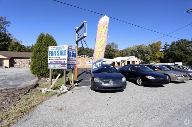
Property Record
1345 W Us Highway 20, Chesterton, IN 46304
NEARBY LISTINGS FOR SALE OR LEASE
Property Detail
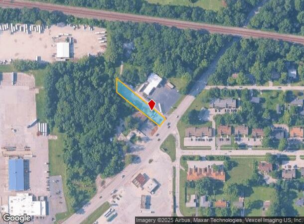
1345 W Us Highway 20
64-03-34-254-007.000-026
PAR W12 GOVT LOT 3 W RD 20 & PT IN SE1/4 34-37-6 .50A
Storebuilding
Porter
X
Indiana
18127C0126D
3
2023
0.50 AC
2024
Porter County
050302
Chicago
768 SF
Chicago-Naperville-Elgin, IL-IN-WI
DEMOGRAPHICS near 1345 W Us Highway 20
1 Mile
3 Mile
5 Mile
2024 Total Population
2,582
21,801
47,243
2029 Population
2,658
22,441
48,723
Pop Growth 2024-2029
+ 2.94%
+ 2.94%
+ 3.13%
Average Age
38
40
41
2024 Total Households
961
8,760
18,263
HH Growth 2024-2029
+ 3.02%
+ 2.99%
+ 3.19%
Median Household Inc
$76,396
$82,960
$84,317
Avg Household Size
2.70
2.40
2.50
2024 Avg HH Vehicles
2.00
2.00
2.00
Median Home Value
$243,965
$240,225
$252,391
Median Year Built
1992
1981
1986
Nearby Places
Map Layers
Map Styles
 Street
 Aerial
- Restaurants
- Banks
- Shops
- Fitness
- Groceries
PUBLIC TRANSPORTATION
COMMUTER RAIL
Dune Park (Chesterton) Station (South Shore Line - Northern Indiana Commuter Transportation District (South Shore Line))
DRIVE
WALK
Distance
Dune Park (Chesterton) Station (South Shore Line - Northern Indiana Commuter Transportation District (South Shore Line))
5 min
3.1 mi
Ogden Dunes (Portage) Station (South Shore Line - Northern Indiana Commuter Transportation District (South Shore Line))
DRIVE
WALK
Distance
Ogden Dunes (Portage) Station (South Shore Line - Northern Indiana Commuter Transportation District (South Shore Line))
9 min
6.1 mi
Freight Ports
Port Milwaukee
DRIVE
WALK
Distance
Port Milwaukee
161 min
129.3 mi
SALE & LEASE HISTORY
LISTING DATE
SALE/LEASE

Aug 09, 2017
For Sale
Nearby Properties
Address
Land Use
TOTAL SIZE
Lot Size
Zoning
Address
Land Use
TOTAL SIZE
Lot Size
Zoning
5,092,064 SF
0.06 AC
Address
Land Use
TOTAL SIZE
Lot Size
Zoning
3,430,063 SF
0.04 AC
Address
Land Use
TOTAL SIZE
Lot Size
Zoning
174,766 SF
87 SF
Address
Land Use
TOTAL SIZE
Lot Size
Zoning
789,622 SF
0.02 AC
Address
Land Use
TOTAL SIZE
Lot Size
Zoning
167,850 SF
46.39 AC
Address
Land Use
TOTAL SIZE
Lot Size
Zoning
108,528 SF
10.28 AC
Address
Land Use
TOTAL SIZE
Lot Size
Zoning
233,491 SF
174 SF
Address
Land Use
TOTAL SIZE
Lot Size
Zoning
73,376 SF
44 SF
Address
Land Use
TOTAL SIZE
Lot Size
Zoning
61,873 SF
44 SF
Address
Land Use
TOTAL SIZE
Lot Size
Zoning
38,337 SF
44 SF
Address
Land Use
TOTAL SIZE
Lot Size
Zoning
478,084 SF
0.01 AC
Address
Land Use
TOTAL SIZE
Lot Size
Zoning
114,061 SF
6.26 AC
Address
Land Use
TOTAL SIZE
Lot Size
Zoning
61,561 SF
3.71 AC
Address
Land Use
TOTAL SIZE
Lot Size
Zoning
159,933 SF
0.01 AC
Address
Land Use
TOTAL SIZE
Lot Size
Zoning
34,360 SF
131 SF
Address
Land Use
TOTAL SIZE
Lot Size
Zoning
164,640 SF
44 SF
Address
Land Use
TOTAL SIZE
Lot Size
Zoning
62,401 SF
44 SF
Address
Land Use
TOTAL SIZE
Lot Size
Zoning
174,960 SF
Address
Land Use
TOTAL SIZE
Lot Size
Zoning
60,861 SF
44 SF
Address
Land Use
TOTAL SIZE
Lot Size
Zoning
90,396 SF
6.82 AC
Address
Land Use
TOTAL SIZE
Lot Size
Zoning
63,357 SF
44 SF
Address
Land Use
TOTAL SIZE
Lot Size
Zoning
91,750 SF
44 SF
Address
Land Use
TOTAL SIZE
Lot Size
Zoning
62,261 SF
44 SF
Address
Land Use
TOTAL SIZE
Lot Size
Zoning
38,724 SF
1.82 AC
Address
Land Use
TOTAL SIZE
Lot Size
Zoning
20,400 SF
44 SF
Address
Land Use
TOTAL SIZE
Lot Size
Zoning
27,375 SF
174 SF
Address
Land Use
TOTAL SIZE
Lot Size
Zoning
4,035 SF
190.83 AC
Address
Land Use
TOTAL SIZE
Lot Size
Zoning
63,117 SF
174 SF
Address
Land Use
TOTAL SIZE
Lot Size
Zoning
72,400 SF
2.82 AC
Address
Land Use
TOTAL SIZE
Lot Size
Zoning
400 SF
7.03 AC
The World's #1 Commercial Real Estate Marketplace
Connect with us
© 2025 CoStar Group
The information above has been obtained from sources believed reliable. While we do not doubt its accuracy we have not verified it and make no guarantee, warranty or representation about it. It is your responsibility to independently confirm its accuracy and completeness. Any projections, opinions, assumptions, or estimates used are for example only and do not represent the current or future performance of the property. The value of this transaction to you depends on tax and other factors which should be evaluated by your tax, financial, and legal advisors. You and your advisors should conduct a careful, independent investigation of the property to determine to your satisfaction the suitability of the property for your needs.