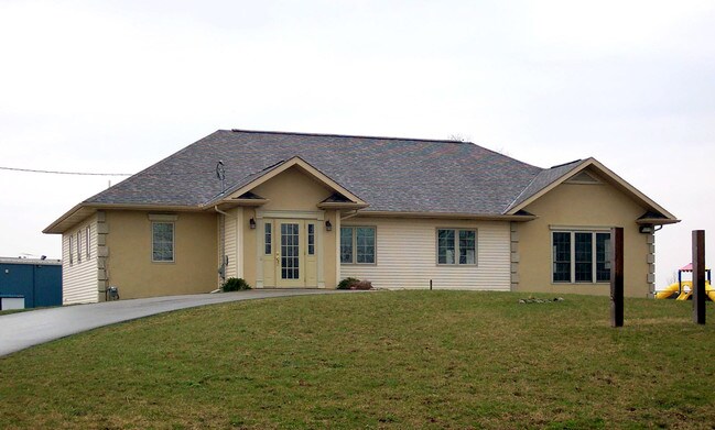
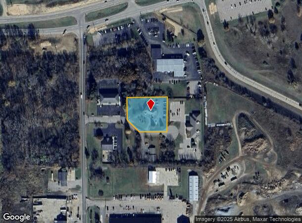
Property Record
13454 Preston Dr, Marshall, MI 49068
NEARBY LISTINGS FOR SALE OR LEASE
-
-
View all Marshall listings for sale on LoopNet.com
Property Detail
13454 Preston Dr
16-450-018-11
MARSHALL TWP T2S-R6W COMM AT THE N 1/4 PST OF SEC 27 TH S 0DEG 36'39"E 2356.63' TH S 74DEG 35'21"W 720.12' TH S 0DEG 36'39"E
Storebuilding
Calhoun
X
Michigan
26025C0238C
1.03 AC
2024
Battle Crk/W Calhoun Cnty
2025
West Michigan
003800
Battle Creek, MI
2,128 SF
DEMOGRAPHICS near 13454 Preston Dr
1 Mile
3 Mile
5 Mile
2024 Total Population
1,096
8,796
12,213
2029 Population
1,091
8,684
12,053
Pop Growth 2024-2029
(0.46%)
(1.27%)
(1.31%)
Average Age
41
43
43
2024 Total Households
515
3,842
5,183
HH Growth 2024-2029
(0.19%)
(1.20%)
(1.23%)
Median Household Inc
$60,638
$68,920
$71,743
Avg Household Size
2.10
2.20
2.30
2024 Avg HH Vehicles
2.00
2.00
2.00
Median Home Value
$179,326
$179,559
$185,908
Median Year Built
1965
1956
1959
Nearby Places
Map Layers
Map Styles
 Street
 Aerial
- Restaurants
- Banks
- Shops
- Fitness
- Groceries
PUBLIC TRANSPORTATION
AIRPORT
Kalamazoo/Battle Creek International
DRIVE
WALK
Distance
Kalamazoo/Battle Creek International
44 min
33.3 mi
Nearby Properties
Address
Land Use
TOTAL SIZE
Lot Size
Zoning
Address
Land Use
TOTAL SIZE
Lot Size
Zoning
1,600,000 SF
Address
Land Use
TOTAL SIZE
Lot Size
Zoning
26,575 SF
731.40 AC
Address
Land Use
TOTAL SIZE
Lot Size
Zoning
160,000 SF
68.23 AC
Address
Land Use
TOTAL SIZE
Lot Size
Zoning
110,286 SF
9.22 AC
I-1
Address
Land Use
TOTAL SIZE
Lot Size
Zoning
400,000 SF
Address
Land Use
TOTAL SIZE
Lot Size
Zoning
251,089 SF
15 AC
I-1
Address
Land Use
TOTAL SIZE
Lot Size
Zoning
89,699 SF
7.93 AC
B-4
Address
Land Use
TOTAL SIZE
Lot Size
Zoning
245,908 SF
11.46 AC
I-1
Address
Land Use
TOTAL SIZE
Lot Size
Zoning
50,700 SF
Address
Land Use
TOTAL SIZE
Lot Size
Zoning
80,288 SF
4.22 AC
MFRD
Address
Land Use
TOTAL SIZE
Lot Size
Zoning
241.30 AC
LI
Address
Land Use
TOTAL SIZE
Lot Size
Zoning
1,226,575 SF
337.10 AC
Address
Land Use
TOTAL SIZE
Lot Size
Zoning
56,000 SF
9.59 AC
I-1
Address
Land Use
TOTAL SIZE
Lot Size
Zoning
10,085 SF
3.88 AC
B4-GEN (IA
Address
Land Use
TOTAL SIZE
Lot Size
Zoning
57,700 SF
8.31 AC
I-1
Address
Land Use
TOTAL SIZE
Lot Size
Zoning
111,882 SF
59.51 AC
I-2
Address
Land Use
TOTAL SIZE
Lot Size
Zoning
36,660 SF
6.73 AC
I-1
Address
Land Use
TOTAL SIZE
Lot Size
Zoning
41,934 SF
11.21 AC
I-1
Address
Land Use
TOTAL SIZE
Lot Size
Zoning
71,725 SF
4.74 AC
I-1
Address
Land Use
TOTAL SIZE
Lot Size
Zoning
103,608 SF
15 AC
I-1
Address
Land Use
TOTAL SIZE
Lot Size
Zoning
59.25 AC
POSD
Address
Land Use
TOTAL SIZE
Lot Size
Zoning
310.28 AC
AR
Address
Land Use
TOTAL SIZE
Lot Size
Zoning
39,862 SF
2.88 AC
FS FREEWAY
Address
Land Use
TOTAL SIZE
Lot Size
Zoning
59,916 SF
5.58 AC
I-1
Address
Land Use
TOTAL SIZE
Lot Size
Zoning
241.30 AC
LI
Address
Land Use
TOTAL SIZE
Lot Size
Zoning
54,612 SF
3.70 AC
MFRD
Address
Land Use
TOTAL SIZE
Lot Size
Zoning
74,904 SF
4.91 AC
MFRD
Address
Land Use
TOTAL SIZE
Lot Size
Zoning
45,659 SF
3.54 AC
B-4
Address
Land Use
TOTAL SIZE
Lot Size
Zoning
137,522 SF
14.15 AC
I-2
Address
Land Use
TOTAL SIZE
Lot Size
Zoning
33,400 SF
3.08 AC
B-4 GEN
The World's #1 Commercial Real Estate Marketplace
Connect with us
© 2025 CoStar Group
The information above has been obtained from sources believed reliable. While we do not doubt its accuracy we have not verified it and make no guarantee, warranty or representation about it. It is your responsibility to independently confirm its accuracy and completeness. Any projections, opinions, assumptions, or estimates used are for example only and do not represent the current or future performance of the property. The value of this transaction to you depends on tax and other factors which should be evaluated by your tax, financial, and legal advisors. You and your advisors should conduct a careful, independent investigation of the property to determine to your satisfaction the suitability of the property for your needs.