Property Record
1347 Johnson Ln, Billings, MT 59101
Current Lease Availabilities
NEARBY LISTINGS FOR SALE OR LEASE
-
-
View all Billings listings for lease on LoopNet.com
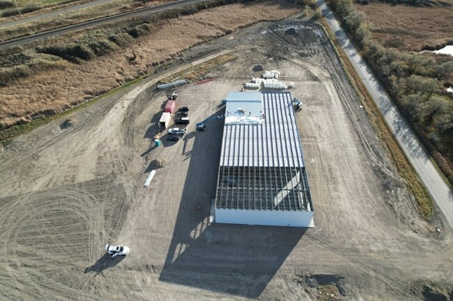
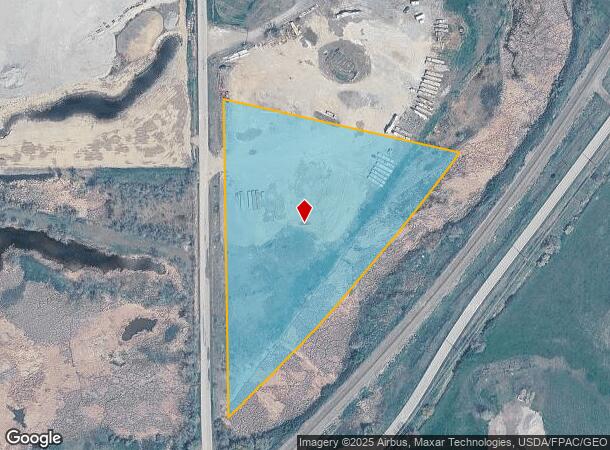
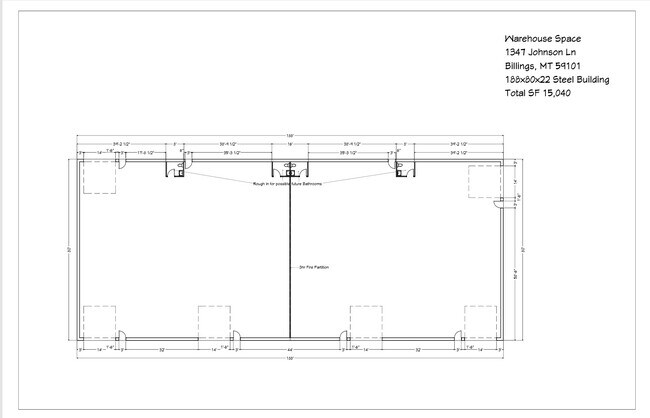
Property Detail
1347 Johnson Ln
Billings, MT
Jdw Industrial Park Sub (13)
03-1034-19-1-20-11-0000
JDW INDUSTRIAL PARK SUB (13), S19, T01 N, R27 E, BLOCK 1, LOT 1, (13)
Commercialacreage
Yellowstone
AE
Montana
30111C1285E
1
2024
6.72 AC
2025
Billings
000902
Other Market Areas
DEMOGRAPHICS near 1347 Johnson Ln
1 Mile
3 Mile
5 Mile
2024 Total Population
1,880
18,866
43,198
2029 Population
1,897
19,250
44,381
Pop Growth 2024-2029
+ 0.90%
+ 2.04%
+ 2.74%
Average Age
40
39
39
2024 Total Households
724
7,267
17,109
HH Growth 2024-2029
+ 0.97%
+ 2.15%
+ 2.93%
Median Household Inc
$78,077
$71,591
$69,463
Avg Household Size
2.50
2.50
2.40
2024 Avg HH Vehicles
2.00
2.00
2.00
Median Home Value
$320,136
$339,853
$349,129
Median Year Built
1985
1987
1985
Nearby Places
- Restaurants
- Banks
- Shops
- Fitness
- Groceries
PUBLIC TRANSPORTATION
AIRPORT
Billings Logan International
DRIVE
WALK
Distance
Billings Logan International
27 min
11.1 mi
Freight Ports
Port of Everett
DRIVE
WALK
Distance
Port of Everett
890 min
847.5 mi
Nearby Properties
Address
Land Use
TOTAL SIZE
Lot Size
Zoning
Address
Land Use
TOTAL SIZE
Lot Size
Zoning
240,253 SF
282.66 AC
HI
Address
Land Use
TOTAL SIZE
Lot Size
Zoning
117,130 SF
29.86 AC
R-70
Address
Land Use
TOTAL SIZE
Lot Size
Zoning
181,007 SF
19.57 AC
Address
Land Use
TOTAL SIZE
Lot Size
Zoning
77,721 SF
20 AC
Address
Land Use
TOTAL SIZE
Lot Size
Zoning
25,045 SF
10.77 AC
R-70
Address
Land Use
TOTAL SIZE
Lot Size
Zoning
72,949 SF
4.12 AC
HC
Address
Land Use
TOTAL SIZE
Lot Size
Zoning
128,015 SF
17.89 AC
CI
Address
Land Use
TOTAL SIZE
Lot Size
Zoning
42,704 SF
8.56 AC
R-70
Address
Land Use
TOTAL SIZE
Lot Size
Zoning
73,129 SF
23.58 AC
Address
Land Use
TOTAL SIZE
Lot Size
Zoning
21,162 SF
3.83 AC
RMF
Address
Land Use
TOTAL SIZE
Lot Size
Zoning
104,596 SF
10.32 AC
HI
Address
Land Use
TOTAL SIZE
Lot Size
Zoning
22,574 SF
23.53 AC
CI
Address
Land Use
TOTAL SIZE
Lot Size
Zoning
65,662 SF
41.39 AC
Address
Land Use
TOTAL SIZE
Lot Size
Zoning
42.39 AC
RMH
Address
Land Use
TOTAL SIZE
Lot Size
Zoning
11,120 SF
39.02 AC
RMH
Address
Land Use
TOTAL SIZE
Lot Size
Zoning
24,126 SF
2.52 AC
Address
Land Use
TOTAL SIZE
Lot Size
Zoning
45,856 SF
6.55 AC
RMF
Address
Land Use
TOTAL SIZE
Lot Size
Zoning
33,450 SF
11.56 AC
R-96
Address
Land Use
TOTAL SIZE
Lot Size
Zoning
51,621 SF
15.68 AC
Address
Land Use
TOTAL SIZE
Lot Size
Zoning
82,801 SF
11.36 AC
HC
Address
Land Use
TOTAL SIZE
Lot Size
Zoning
78,132 SF
4.49 AC
HC
Address
Land Use
TOTAL SIZE
Lot Size
Zoning
77,721 SF
4.63 AC
R-70
Address
Land Use
TOTAL SIZE
Lot Size
Zoning
81,794 SF
7.12 AC
HC
Address
Land Use
TOTAL SIZE
Lot Size
Zoning
30,952 SF
4.06 AC
CITY
Address
Land Use
TOTAL SIZE
Lot Size
Zoning
32,130 SF
1.45 AC
Address
Land Use
TOTAL SIZE
Lot Size
Zoning
24,793 SF
3.44 AC
EGCOM
Address
Land Use
TOTAL SIZE
Lot Size
Zoning
8,000 SF
23.10 AC
CI
Address
Land Use
TOTAL SIZE
Lot Size
Zoning
72,300 SF
5.67 AC
HI
Address
Land Use
TOTAL SIZE
Lot Size
Zoning
35,512 SF
2.26 AC
RMF
Address
Land Use
TOTAL SIZE
Lot Size
Zoning
16,202 SF
10.16 AC
NC
The World's #1 Commercial Real Estate Marketplace
Connect with us
© 2025 CoStar Group
The information above has been obtained from sources believed reliable. While we do not doubt its accuracy we have not verified it and make no guarantee, warranty or representation about it. It is your responsibility to independently confirm its accuracy and completeness. Any projections, opinions, assumptions, or estimates used are for example only and do not represent the current or future performance of the property. The value of this transaction to you depends on tax and other factors which should be evaluated by your tax, financial, and legal advisors. You and your advisors should conduct a careful, independent investigation of the property to determine to your satisfaction the suitability of the property for your needs.