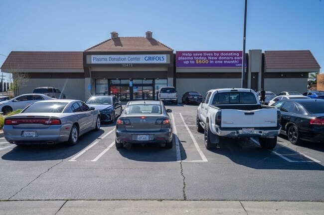
Property Record
13473 Perris Blvd, Moreno Valley, CA 92553


NEARBY LISTINGS FOR SALE OR LEASE
Property Detail
13473 Perris Blvd
Riverside-San Bernardino-Ontario, CA
Bear Valley & Alessandro Development Co
482-152-048
1.25 ACRES M/L IN POR LOT 8 BLK 72 MB 011/010 SB BEAR VALLEY & ALESSANDRO DEVELOPMENT CO
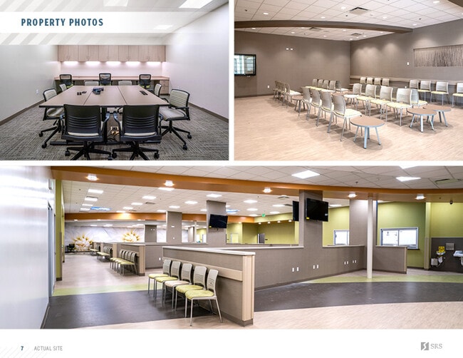
Medicalbuilding
Riverside
X
California
06065C0761G
8
2024
1.25 AC
2025
Moreno Valley/Perris
042521
Inland Empire (California)
15,360 SF
DEMOGRAPHICS near 13473 Perris Blvd
1 Mile
3 Mile
5 Mile
2024 Total Population
26,382
158,707
218,168
2029 Population
27,801
166,644
229,159
Pop Growth 2024-2029
+ 5.38%
+ 5.00%
+ 5.04%
Average Age
34
34
35
2024 Total Households
6,689
41,349
58,119
HH Growth 2024-2029
+ 5.02%
+ 4.56%
+ 4.62%
Median Household Inc
$58,817
$71,408
$78,906
Avg Household Size
3.80
3.70
3.60
2024 Avg HH Vehicles
2.00
2.00
2.00
Median Home Value
$343,201
$374,318
$400,382
Median Year Built
1984
1985
1987
Nearby Places
Map Layers
Map Styles
 Street
 Aerial
- Restaurants
- Banks
- Shops
- Fitness
- Groceries
PUBLIC TRANSPORTATION
COMMUTER RAIL
Moreno Valley/March Field (Metrolink 91-Perris Valley Line - Metrolink Trains)
DRIVE
WALK
Distance
Moreno Valley/March Field (Metrolink 91-Perris Valley Line - Metrolink Trains)
9 min
4.8 mi
AIRPORT
Ontario International
DRIVE
WALK
Distance
Ontario International
34 min
27.1 mi
Freight Ports
Port of Long Beach
DRIVE
WALK
Distance
Port of Long Beach
86 min
66.3 mi
SALE & LEASE HISTORY
LISTING DATE
SALE/LEASE

May 15, 2023
For Sale
May 11, 2021
For Sale
Feb 26, 2018
For Lease
Nearby Properties
Address
Land Use
TOTAL SIZE
Lot Size
Zoning
Address
Land Use
TOTAL SIZE
Lot Size
Zoning
617,000 SF
23.91 AC
W2
Address
Land Use
TOTAL SIZE
Lot Size
Zoning
1,280,446 SF
51.47 AC
Address
Land Use
TOTAL SIZE
Lot Size
Zoning
1,461,146 SF
72.62 AC
Address
Land Use
TOTAL SIZE
Lot Size
Zoning
607,644 SF
26.09 AC
O
Address
Land Use
TOTAL SIZE
Lot Size
Zoning
397,994 SF
19.70 AC
H
Address
Land Use
TOTAL SIZE
Lot Size
Zoning
283,209 SF
16.91 AC
R20
Address
Land Use
TOTAL SIZE
Lot Size
Zoning
63,962 SF
11.43 AC
H
Address
Land Use
TOTAL SIZE
Lot Size
Zoning
1,103,003 SF
47.64 AC
LI
Address
Land Use
TOTAL SIZE
Lot Size
Zoning
91,891 SF
20.61 AC
R20
Address
Land Use
TOTAL SIZE
Lot Size
Zoning
74,096 SF
10.76 AC
SP218
Address
Land Use
TOTAL SIZE
Lot Size
Zoning
430,647 SF
31.09 AC
Address
Land Use
TOTAL SIZE
Lot Size
Zoning
532,926 SF
24.37 AC
Address
Land Use
TOTAL SIZE
Lot Size
Zoning
38,400 SF
15.73 AC
R3
Address
Land Use
TOTAL SIZE
Lot Size
Zoning
400,935 SF
19.07 AC
Address
Land Use
TOTAL SIZE
Lot Size
Zoning
252,504 SF
13.11 AC
SP
Address
Land Use
TOTAL SIZE
Lot Size
Zoning
522,772 SF
26.26 AC
LI
Address
Land Use
TOTAL SIZE
Lot Size
Zoning
34,691 SF
25.86 AC
C
Address
Land Use
TOTAL SIZE
Lot Size
Zoning
41,521 SF
13.43 AC
C
Address
Land Use
TOTAL SIZE
Lot Size
Zoning
366,698 SF
16.03 AC
LI
Address
Land Use
TOTAL SIZE
Lot Size
Zoning
613,174 SF
27.71 AC
Address
Land Use
TOTAL SIZE
Lot Size
Zoning
170,192 SF
10.42 AC
CC
Address
Land Use
TOTAL SIZE
Lot Size
Zoning
126,104 SF
7.73 AC
CC
Address
Land Use
TOTAL SIZE
Lot Size
Zoning
256,795 SF
12 AC
Address
Land Use
TOTAL SIZE
Lot Size
Zoning
104,282 SF
6.71 AC
BP
Address
Land Use
TOTAL SIZE
Lot Size
Zoning
73,760 SF
10.14 AC
Address
Land Use
TOTAL SIZE
Lot Size
Zoning
164,120 SF
9.63 AC
R3
Address
Land Use
TOTAL SIZE
Lot Size
Zoning
212,680 SF
9.78 AC
Address
Land Use
TOTAL SIZE
Lot Size
Zoning
203,944 SF
7.88 AC
Address
Land Use
TOTAL SIZE
Lot Size
Zoning
87,617 SF
2.32 AC
The World's #1 Commercial Real Estate Marketplace
Connect with us
© 2025 CoStar Group
The information above has been obtained from sources believed reliable. While we do not doubt its accuracy we have not verified it and make no guarantee, warranty or representation about it. It is your responsibility to independently confirm its accuracy and completeness. Any projections, opinions, assumptions, or estimates used are for example only and do not represent the current or future performance of the property. The value of this transaction to you depends on tax and other factors which should be evaluated by your tax, financial, and legal advisors. You and your advisors should conduct a careful, independent investigation of the property to determine to your satisfaction the suitability of the property for your needs.