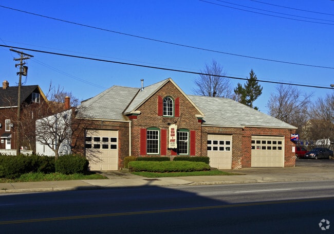
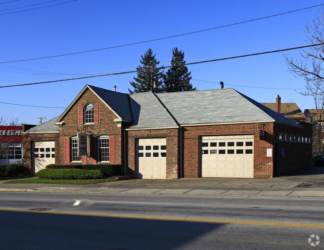
Property Record
13485 Cedar Rd, University Heights, OH 44118
NEARBY LISTINGS FOR SALE OR LEASE
Property Detail
13485 Cedar Rd
Cleveland
Cdrbrk#3
Cleveland-Elyria, OH
57 CDRBRK#3 0004 ALL
722-01-071
Cuyahoga
Autorepair
Ohio
2024
4
2024
0.10 AC
140900
East
3,751 SF
DEMOGRAPHICS near 13485 Cedar Rd
1 Mile
3 Mile
5 Mile
2024 Total Population
21,290
151,343
331,356
2029 Population
20,842
148,815
326,524
Pop Growth 2024-2029
(2.10%)
(1.67%)
(1.46%)
Average Age
39
40
41
2024 Total Households
8,730
65,651
146,548
HH Growth 2024-2029
(2.42%)
(1.66%)
(1.55%)
Median Household Inc
$72,132
$55,193
$43,791
Avg Household Size
2.30
2.10
2.10
2024 Avg HH Vehicles
2.00
1.00
1.00
Median Home Value
$161,041
$172,767
$138,955
Median Year Built
1946
1948
1949
Nearby Places
Map Layers
Map Styles
 Street
 Aerial
- Restaurants
- Banks
- Shops
- Fitness
- Groceries
PUBLIC TRANSPORTATION
AIRPORT
Cleveland-Hopkins International
DRIVE
WALK
Distance
Cleveland-Hopkins International
36 min
19.6 mi
Freight Ports
Port of Toledo
DRIVE
WALK
Distance
Port of Toledo
149 min
120.1 mi
SALE & LEASE HISTORY
LISTING DATE
SALE/LEASE

Sep 24, 2016
For Sale
Sep 24, 2016
For Sale
Nearby Properties
Address
Land Use
TOTAL SIZE
Lot Size
Zoning
Address
Land Use
TOTAL SIZE
Lot Size
Zoning
1,211,519 SF
13.57 AC
GR
Address
Land Use
TOTAL SIZE
Lot Size
Zoning
2,064,168 SF
17.90 AC
GR
Address
Land Use
TOTAL SIZE
Lot Size
Zoning
53.85 AC
2F
Address
Land Use
TOTAL SIZE
Lot Size
Zoning
370,230 SF
4.08 AC
GR
Address
Land Use
TOTAL SIZE
Lot Size
Zoning
500,042 SF
1.34 AC
1F
Address
Land Use
TOTAL SIZE
Lot Size
Zoning
1,066,853 SF
42.18 AC
U-5
Address
Land Use
TOTAL SIZE
Lot Size
Zoning
595,671 SF
14.98 AC
MF3+
Address
Land Use
TOTAL SIZE
Lot Size
Zoning
707,658 SF
17.57 AC
2F
Address
Land Use
TOTAL SIZE
Lot Size
Zoning
243,720 SF
0.20 AC
GR
Address
Land Use
TOTAL SIZE
Lot Size
Zoning
379,326 SF
43.45 AC
CRG
Address
Land Use
TOTAL SIZE
Lot Size
Zoning
374,227 SF
13.10 AC
MF3+
Address
Land Use
TOTAL SIZE
Lot Size
Zoning
455,560 SF
1.23 AC
GR
Address
Land Use
TOTAL SIZE
Lot Size
Zoning
745,953 SF
14.34 AC
MF3+
Address
Land Use
TOTAL SIZE
Lot Size
Zoning
767,400 SF
0.27 AC
GR
Address
Land Use
TOTAL SIZE
Lot Size
Zoning
252,736 SF
3.71 AC
GR
Address
Land Use
TOTAL SIZE
Lot Size
Zoning
282,498 SF
0.71 AC
GR
Address
Land Use
TOTAL SIZE
Lot Size
Zoning
277,792 SF
1.65 AC
Address
Land Use
TOTAL SIZE
Lot Size
Zoning
147,851 SF
2.22 AC
MF3+
Address
Land Use
TOTAL SIZE
Lot Size
Zoning
228,057 SF
6.56 AC
MF3+
Address
Land Use
TOTAL SIZE
Lot Size
Zoning
257,048 SF
17.93 AC
S1
Address
Land Use
TOTAL SIZE
Lot Size
Zoning
440,004 SF
4.25 AC
S2
Address
Land Use
TOTAL SIZE
Lot Size
Zoning
36,098 SF
0.50 AC
GR
Address
Land Use
TOTAL SIZE
Lot Size
Zoning
413,626 SF
21.95 AC
S2
Address
Land Use
TOTAL SIZE
Lot Size
Zoning
572,307 SF
2.91 AC
GR
Address
Land Use
TOTAL SIZE
Lot Size
Zoning
88,946 SF
1.84 AC
MF3+
Address
Land Use
TOTAL SIZE
Lot Size
Zoning
129,725 SF
4.35 AC
MF3+
Address
Land Use
TOTAL SIZE
Lot Size
Zoning
126,670 SF
2.57 AC
MF3+
Address
Land Use
TOTAL SIZE
Lot Size
Zoning
160,171 SF
9.14 AC
MF3+
Address
Land Use
TOTAL SIZE
Lot Size
Zoning
410,013 SF
1.39 AC
GR
Address
Land Use
TOTAL SIZE
Lot Size
Zoning
91,540 SF
14.35 AC
CRG
The World's #1 Commercial Real Estate Marketplace
Connect with us
© 2026 CoStar Group
The information above has been obtained from sources believed reliable. While we do not doubt its accuracy we have not verified it and make no guarantee, warranty or representation about it. It is your responsibility to independently confirm its accuracy and completeness. Any projections, opinions, assumptions, or estimates used are for example only and do not represent the current or future performance of the property. The value of this transaction to you depends on tax and other factors which should be evaluated by your tax, financial, and legal advisors. You and your advisors should conduct a careful, independent investigation of the property to determine to your satisfaction the suitability of the property for your needs.