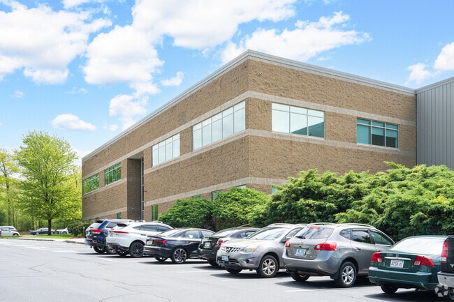
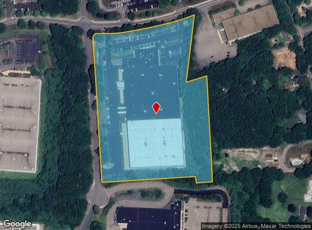
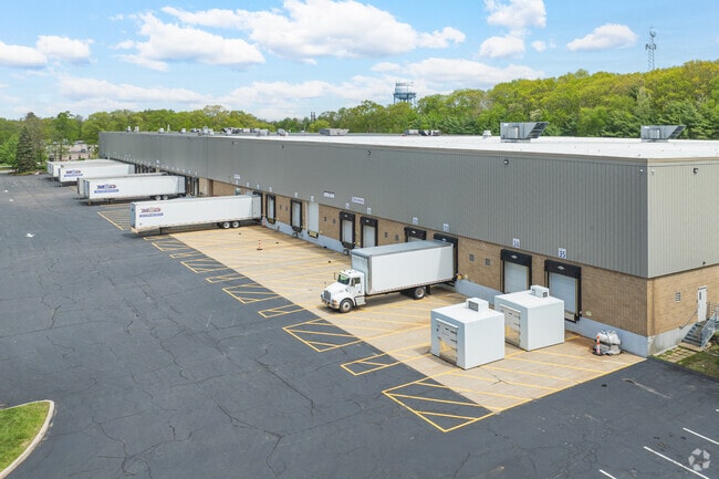
Property Record
135 Constitution Blvd, Franklin, MA 02038
Current Lease Availabilities
NEARBY LISTINGS FOR SALE OR LEASE
Property Detail
135 Constitution Blvd
FRAN-000319-000000-000013
Norfolk
Warehouse
Massachusetts
X
13
25021C0317F
12.07 AC
2025
I-95 Corridor South
2025
Boston
442201
Boston-Cambridge-Newton, MA-NH
226,472 SF
DEMOGRAPHICS near 135 Constitution Blvd
1 mile
3 mile
5 mile
2024 Total Population
2,288
24,218
65,282
2029 Population
2,290
24,042
65,007
Pop Growth 2024-2029
+ 0.09%
(0.73%)
(0.42%)
Average Age
42
41
41
2024 Total Households
860
8,982
24,020
HH Growth 2024-2029
+ 0.12%
(0.77%)
(0.47%)
Median Household Inc
$106,570
$124,920
$129,482
Avg Household Size
2.60
2.60
2.60
2024 Avg HH Vehicles
2.00
2.00
2.00
Median Home Value
$560,060
$552,202
$497,294
Median Year Built
1994
1983
1981
Nearby Places
Map Layers
Map Styles
 Street
 Aerial
Transit
 Traffic
 Biking
Places
Listings with unknown addresses are not visible on the map
- Restaurants
- Banks
- Shops
- Fitness
- Groceries
PUBLIC TRANSPORTATION
COMMUTER RAIL
Franklin (Franklin Line - Massachusetts Bay Transportation Authority Commuter Rail (Purple Line))
Drive
Walk
Distance
Franklin (Franklin Line - Massachusetts Bay Transportation Authority Commuter Rail (Purple Line))
8 min
2.6 mi
Forge Park/Route 495 (Franklin Line - Massachusetts Bay Transportation Authority Commuter Rail (Purple Line))
Drive
Walk
Distance
Forge Park/Route 495 (Franklin Line - Massachusetts Bay Transportation Authority Commuter Rail (Purple Line))
10 min
4.2 mi
AIRPORT
Rhode Island Tf Green International
Drive
Walk
Distance
Rhode Island Tf Green International
50 min
27.5 mi
Worcester Regional
Drive
Walk
Distance
Worcester Regional
57 min
37.4 mi
General Edward Lawrence Logan International
Drive
Walk
Distance
General Edward Lawrence Logan International
61 min
41.0 mi
Nearby Properties
Address
Land Use
TOTAL SIZE
Lot Size
Zoning
Address
Land Use
TOTAL SIZE
Lot Size
Zoning
85.04 AC
Address
Land Use
TOTAL SIZE
Lot Size
Zoning
23.38 AC
Address
Land Use
TOTAL SIZE
Lot Size
Zoning
Address
Land Use
TOTAL SIZE
Lot Size
Zoning
39.30 AC
Address
Land Use
TOTAL SIZE
Lot Size
Zoning
31.57 AC
Address
Land Use
TOTAL SIZE
Lot Size
Zoning
0.58 AC
Address
Land Use
TOTAL SIZE
Lot Size
Zoning
148,387 SF
47.03 AC
Address
Land Use
TOTAL SIZE
Lot Size
Zoning
4.14 AC
Address
Land Use
TOTAL SIZE
Lot Size
Zoning
300,000 SF
37.97 AC
Address
Land Use
TOTAL SIZE
Lot Size
Zoning
16.99 AC
Address
Land Use
TOTAL SIZE
Lot Size
Zoning
232,152 SF
17.07 AC
Address
Land Use
TOTAL SIZE
Lot Size
Zoning
39.40 AC
Address
Land Use
TOTAL SIZE
Lot Size
Zoning
152,752 SF
10.21 AC
Address
Land Use
TOTAL SIZE
Lot Size
Zoning
209,282 SF
15.61 AC
Address
Land Use
TOTAL SIZE
Lot Size
Zoning
241,740 SF
14.60 AC
Address
Land Use
TOTAL SIZE
Lot Size
Zoning
204,365 SF
16.23 AC
Address
Land Use
TOTAL SIZE
Lot Size
Zoning
269,098 SF
24.96 AC
Address
Land Use
TOTAL SIZE
Lot Size
Zoning
176,269 SF
40.56 AC
B-2 80
Address
Land Use
TOTAL SIZE
Lot Size
Zoning
130,500 SF
9.52 AC
Address
Land Use
TOTAL SIZE
Lot Size
Zoning
3,024 SF
12.47 AC
C-1 80
Address
Land Use
TOTAL SIZE
Lot Size
Zoning
8.93 AC
Address
Land Use
TOTAL SIZE
Lot Size
Zoning
259,280 SF
20 AC
Address
Land Use
TOTAL SIZE
Lot Size
Zoning
50,610 SF
20.50 AC
Address
Land Use
TOTAL SIZE
Lot Size
Zoning
12.32 AC
Address
Land Use
TOTAL SIZE
Lot Size
Zoning
43.12 AC
Address
Land Use
TOTAL SIZE
Lot Size
Zoning
101,882 SF
7.10 AC
Address
Land Use
TOTAL SIZE
Lot Size
Zoning
84,774 SF
3.98 AC
Address
Land Use
TOTAL SIZE
Lot Size
Zoning
9,945 SF
16.72 AC
C-2 80
Address
Land Use
TOTAL SIZE
Lot Size
Zoning
73,287 SF
22.03 AC
The World's #1 Commercial Real Estate Marketplace
Connect with us
© 2026 CoStar Group
The information above has been obtained from sources believed reliable. While we do not doubt its accuracy we have not verified it and make no guarantee, warranty or representation about it. It is your responsibility to independently confirm its accuracy and completeness. Any projections, opinions, assumptions, or estimates used are for example only and do not represent the current or future performance of the property. The value of this transaction to you depends on tax and other factors which should be evaluated by your tax, financial, and legal advisors. You and your advisors should conduct a careful, independent investigation of the property to determine to your satisfaction the suitability of the property for your needs.