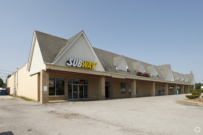
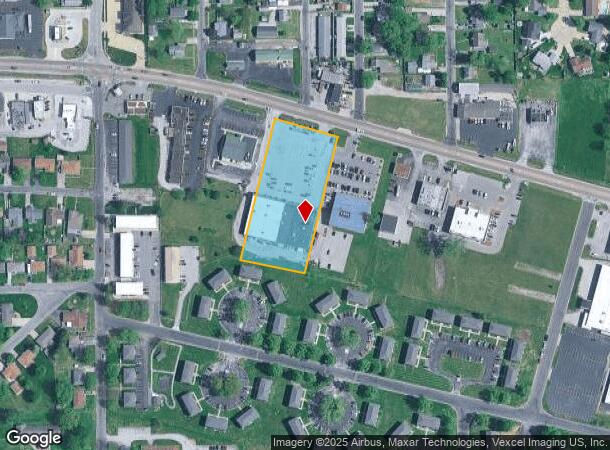
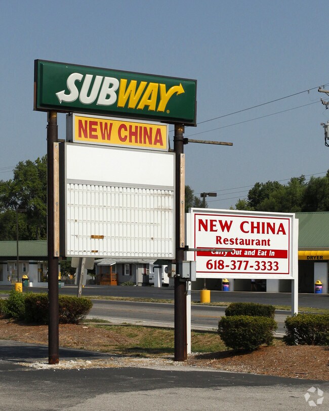
Property Record
135 E Bethalto Dr, Bethalto, IL 62010
NEARBY LISTINGS FOR SALE OR LEASE
-
-
View all Bethalto listings for sale on LoopNet.com
Property Detail
135 E Bethalto Dr
St. Louis, MO-IL
Chateau Des Fleurs 1St Add
15-2-09-07-09-105-005.003
CHATEAU DES FLEURS 1ST ADD MID PT OL B 201'X446IRR
Stripcommercialcenter
Madison
2024
Illinois
2024
2.06 AC
402803
NE Metro Illinois
24,000 SF
St. Louis
DEMOGRAPHICS near 135 E Bethalto Dr
1 Mile
3 Mile
5 Mile
2024 Total Population
5,422
18,991
42,111
2029 Population
5,357
18,752
41,612
Pop Growth 2024-2029
(1.20%)
(1.26%)
(1.18%)
Average Age
41
42
42
2024 Total Households
2,412
8,083
17,892
HH Growth 2024-2029
(1.20%)
(1.27%)
(1.22%)
Median Household Inc
$66,414
$68,939
$62,999
Avg Household Size
2.20
2.30
2.30
2024 Avg HH Vehicles
2.00
2.00
2.00
Median Home Value
$152,475
$150,319
$130,873
Median Year Built
1973
1967
1962
Nearby Places
Map Layers
Map Styles
 Street
 Aerial
- Restaurants
- Banks
- Shops
- Fitness
- Groceries
PUBLIC TRANSPORTATION
COMMUTER RAIL
DRIVE
WALK
Distance
15 min
7.7 mi
AIRPORT
St Louis Lambert International
DRIVE
WALK
Distance
St Louis Lambert International
41 min
27.9 mi
Scott AFB/Midamerica St Louis
DRIVE
WALK
Distance
Scott AFB/Midamerica St Louis
59 min
40.7 mi
SALE & LEASE HISTORY
LISTING DATE
SALE/LEASE

Oct 13, 2017
For Sale
Nearby Properties
Address
Land Use
TOTAL SIZE
Lot Size
Zoning
Address
Land Use
TOTAL SIZE
Lot Size
Zoning
215,635 SF
23.08 AC
Address
Land Use
TOTAL SIZE
Lot Size
Zoning
147,365 SF
1.91 AC
Address
Land Use
TOTAL SIZE
Lot Size
Zoning
66,140 SF
9.79 AC
Address
Land Use
TOTAL SIZE
Lot Size
Zoning
62,859 SF
12 AC
Address
Land Use
TOTAL SIZE
Lot Size
Zoning
58,900 SF
2.05 AC
Address
Land Use
TOTAL SIZE
Lot Size
Zoning
20,000 SF
10.81 AC
Address
Land Use
TOTAL SIZE
Lot Size
Zoning
55,020 SF
2.85 AC
Address
Land Use
TOTAL SIZE
Lot Size
Zoning
21,200 SF
4 AC
Address
Land Use
TOTAL SIZE
Lot Size
Zoning
17,760 SF
2.72 AC
Address
Land Use
TOTAL SIZE
Lot Size
Zoning
26,320 SF
4.82 AC
Address
Land Use
TOTAL SIZE
Lot Size
Zoning
21,614 SF
0.62 AC
Address
Land Use
TOTAL SIZE
Lot Size
Zoning
9,000 SF
13.68 AC
Address
Land Use
TOTAL SIZE
Lot Size
Zoning
111,616 SF
10 AC
Address
Land Use
TOTAL SIZE
Lot Size
Zoning
41,203 SF
Address
Land Use
TOTAL SIZE
Lot Size
Zoning
16,816 SF
2.85 AC
Address
Land Use
TOTAL SIZE
Lot Size
Zoning
19,294 SF
3.27 AC
Address
Land Use
TOTAL SIZE
Lot Size
Zoning
11,275 SF
2.39 AC
Address
Land Use
TOTAL SIZE
Lot Size
Zoning
22,044 SF
5 AC
Address
Land Use
TOTAL SIZE
Lot Size
Zoning
27,000 SF
10 AC
Address
Land Use
TOTAL SIZE
Lot Size
Zoning
8,992 SF
2 AC
Address
Land Use
TOTAL SIZE
Lot Size
Zoning
6,000 SF
5.78 AC
Address
Land Use
TOTAL SIZE
Lot Size
Zoning
24,080 SF
10.70 AC
Address
Land Use
TOTAL SIZE
Lot Size
Zoning
24,148 SF
2.39 AC
Address
Land Use
TOTAL SIZE
Lot Size
Zoning
4,636 SF
0.79 AC
Address
Land Use
TOTAL SIZE
Lot Size
Zoning
3,002 SF
1.85 AC
Address
Land Use
TOTAL SIZE
Lot Size
Zoning
5,325 SF
0.69 AC
Address
Land Use
TOTAL SIZE
Lot Size
Zoning
1,307 SF
14.66 AC
Address
Land Use
TOTAL SIZE
Lot Size
Zoning
13,809 SF
1.91 AC
Address
Land Use
TOTAL SIZE
Lot Size
Zoning
2,584 SF
1.66 AC
Address
Land Use
TOTAL SIZE
Lot Size
Zoning
8,134 SF
1.17 AC
The World's #1 Commercial Real Estate Marketplace
Connect with us
© 2026 CoStar Group
The information above has been obtained from sources believed reliable. While we do not doubt its accuracy we have not verified it and make no guarantee, warranty or representation about it. It is your responsibility to independently confirm its accuracy and completeness. Any projections, opinions, assumptions, or estimates used are for example only and do not represent the current or future performance of the property. The value of this transaction to you depends on tax and other factors which should be evaluated by your tax, financial, and legal advisors. You and your advisors should conduct a careful, independent investigation of the property to determine to your satisfaction the suitability of the property for your needs.