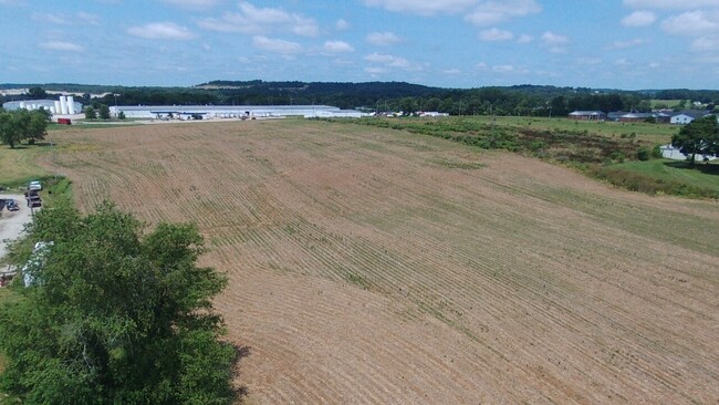
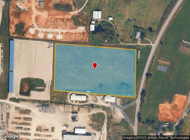
Property Record
135 Highway 135 N, Corydon, IN 47112
NEARBY LISTINGS FOR SALE OR LEASE
Property Detail
135 Highway 135 N
Louisville-Jefferson County, KY-IN
004-01664-00 PT E 1/2 SE QR 13-3-3 9.11 AC SURVEY ON FILE 09/28/2022
31-09-13-400-013.000-007
Harrison
Agriculturalland
Indiana
2024
9.11 AC
2024
Harrison County
060402
Louisville
DEMOGRAPHICS near 135 Highway 135 N
1 Mile
3 Mile
5 Mile
2024 Total Population
4,094
10,332
14,187
2029 Population
4,182
10,588
14,454
Pop Growth 2024-2029
+ 2.15%
+ 2.48%
+ 1.88%
Average Age
40
41
41
2024 Total Households
1,669
4,100
5,587
HH Growth 2024-2029
+ 2.16%
+ 2.51%
+ 1.90%
Median Household Inc
$44,893
$57,121
$59,779
Avg Household Size
2.40
2.40
2.40
2024 Avg HH Vehicles
2.00
2.00
2.00
Median Home Value
$208,043
$204,444
$209,453
Median Year Built
1993
1991
1990
Nearby Places
Map Layers
Map Styles
 Street
 Aerial
- Restaurants
- Banks
- Shops
- Fitness
- Groceries
PUBLIC TRANSPORTATION
AIRPORT
Louisville Muhammad Ali International
DRIVE
WALK
Distance
Louisville Muhammad Ali International
44 min
30.8 mi
Freight Ports
Port of Toledo
DRIVE
WALK
Distance
Port of Toledo
379 min
328.1 mi
SALE & LEASE HISTORY
LISTING DATE
SALE/LEASE

Nov 30, 2021
For Sale
Nearby Properties
Address
Land Use
TOTAL SIZE
Lot Size
Zoning
Address
Land Use
TOTAL SIZE
Lot Size
Zoning
182,961 SF
19.06 AC
Address
Land Use
TOTAL SIZE
Lot Size
Zoning
54,210 SF
8.19 AC
Address
Land Use
TOTAL SIZE
Lot Size
Zoning
38,982 SF
3.65 AC
Address
Land Use
TOTAL SIZE
Lot Size
Zoning
161,069 SF
18.73 AC
Address
Land Use
TOTAL SIZE
Lot Size
Zoning
195,415 SF
0.88 AC
Address
Land Use
TOTAL SIZE
Lot Size
Zoning
84,016 SF
14.65 AC
Address
Land Use
TOTAL SIZE
Lot Size
Zoning
2,592 SF
39.40 AC
Address
Land Use
TOTAL SIZE
Lot Size
Zoning
70,500 SF
20.80 AC
Address
Land Use
TOTAL SIZE
Lot Size
Zoning
41,709 SF
2.03 AC
Address
Land Use
TOTAL SIZE
Lot Size
Zoning
32,383 SF
1.49 AC
Address
Land Use
TOTAL SIZE
Lot Size
Zoning
201,800 SF
29.09 AC
Address
Land Use
TOTAL SIZE
Lot Size
Zoning
12,990 SF
3.41 AC
Address
Land Use
TOTAL SIZE
Lot Size
Zoning
37,631 SF
1.54 AC
Address
Land Use
TOTAL SIZE
Lot Size
Zoning
31,960 SF
2.64 AC
Address
Land Use
TOTAL SIZE
Lot Size
Zoning
34,792 SF
1.98 AC
Address
Land Use
TOTAL SIZE
Lot Size
Zoning
8,384 SF
3.17 AC
Address
Land Use
TOTAL SIZE
Lot Size
Zoning
11,212 SF
6.51 AC
Address
Land Use
TOTAL SIZE
Lot Size
Zoning
51,108 SF
10 AC
Address
Land Use
TOTAL SIZE
Lot Size
Zoning
19,010 SF
4 AC
Address
Land Use
TOTAL SIZE
Lot Size
Zoning
42,988 SF
0.67 AC
Address
Land Use
TOTAL SIZE
Lot Size
Zoning
16,284 SF
2.87 AC
Address
Land Use
TOTAL SIZE
Lot Size
Zoning
34,852 SF
3.94 AC
Address
Land Use
TOTAL SIZE
Lot Size
Zoning
13,448 SF
1.82 AC
Address
Land Use
TOTAL SIZE
Lot Size
Zoning
36,912 SF
2 AC
Address
Land Use
TOTAL SIZE
Lot Size
Zoning
31,094 SF
5.17 AC
Address
Land Use
TOTAL SIZE
Lot Size
Zoning
41,908 SF
3.37 AC
Address
Land Use
TOTAL SIZE
Lot Size
Zoning
24,720 SF
6.59 AC
Address
Land Use
TOTAL SIZE
Lot Size
Zoning
17,336 SF
21.90 AC
Address
Land Use
TOTAL SIZE
Lot Size
Zoning
9,400 SF
3.98 AC
Address
Land Use
TOTAL SIZE
Lot Size
Zoning
6,400 SF
4.21 AC
The World's #1 Commercial Real Estate Marketplace
Connect with us
© 2025 CoStar Group
The information above has been obtained from sources believed reliable. While we do not doubt its accuracy we have not verified it and make no guarantee, warranty or representation about it. It is your responsibility to independently confirm its accuracy and completeness. Any projections, opinions, assumptions, or estimates used are for example only and do not represent the current or future performance of the property. The value of this transaction to you depends on tax and other factors which should be evaluated by your tax, financial, and legal advisors. You and your advisors should conduct a careful, independent investigation of the property to determine to your satisfaction the suitability of the property for your needs.