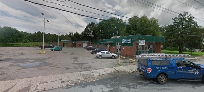
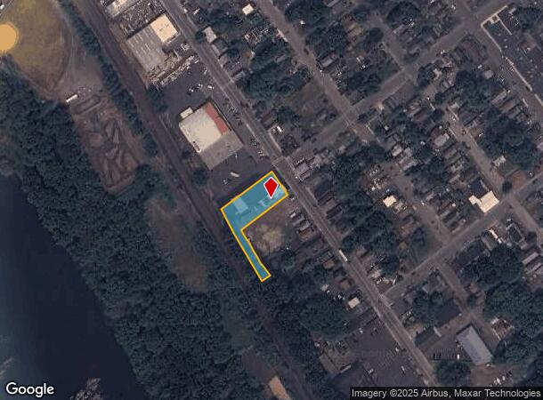
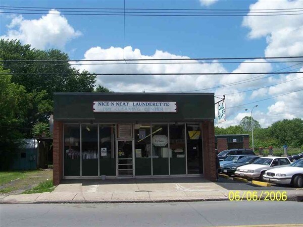
Property Record
135 Jersey Ave, Port Jervis, NY 12771
NEARBY LISTINGS FOR SALE OR LEASE
Property Detail
135 Jersey Ave
331300-018-000-0003-012.200-0000
131 JA CARWASH 135 JA LAUNDROMAT 911 CHG YR 2000
Commercialnec
Orange
X
New York
34037C0027E
12.20
2024
0.01 AC
2024
Middletown
002200
Northern New Jersey
4,290 SF
New York-Jersey City-White Plains, NY-NJ
DEMOGRAPHICS near 135 Jersey Ave
1 Mile
3 Mile
5 Mile
2024 Total Population
9,220
15,553
20,926
2029 Population
9,481
16,028
21,495
Pop Growth 2024-2029
+ 2.83%
+ 3.05%
+ 2.72%
Average Age
40
42
43
2024 Total Households
3,715
6,392
8,504
HH Growth 2024-2029
+ 2.93%
+ 3.25%
+ 2.90%
Median Household Inc
$48,345
$55,983
$60,971
Avg Household Size
2.40
2.40
2.40
2024 Avg HH Vehicles
1.00
2.00
2.00
Median Home Value
$177,158
$197,058
$214,843
Median Year Built
1948
1958
1967
Nearby Places
- Restaurants
- Banks
- Shops
- Fitness
- Groceries
PUBLIC TRANSPORTATION
COMMUTER RAIL
Port Jervis (Bergen County/Port Jervis Line - NJ Transit Commuter Rail (NJ Transit), Main/Port Jervis Line - NJ Transit Commuter Rail (NJ Transit))
DRIVE
WALK
Distance
Port Jervis (Bergen County/Port Jervis Line - NJ Transit Commuter Rail (NJ Transit), Main/Port Jervis Line - NJ Transit Commuter Rail (NJ Transit))
3 min
11 min
0.6 mi
Freight Ports
Port Newark Container Terminal
DRIVE
WALK
Distance
Port Newark Container Terminal
97 min
68.8 mi
SALE & LEASE HISTORY
LISTING DATE
SALE/LEASE

Apr 26, 2019
For Sale
Nearby Properties
Address
Land Use
TOTAL SIZE
Lot Size
Zoning
Address
Land Use
TOTAL SIZE
Lot Size
Zoning
4.40 AC
NMU
Address
Land Use
TOTAL SIZE
Lot Size
Zoning
1,664 SF
1.10 AC
R2
Address
Land Use
TOTAL SIZE
Lot Size
Zoning
4.30 AC
07
Address
Land Use
TOTAL SIZE
Lot Size
Zoning
16.92 AC
C2
Address
Land Use
TOTAL SIZE
Lot Size
Zoning
49.20 AC
Address
Land Use
TOTAL SIZE
Lot Size
Zoning
53,580 SF
7.80 AC
Address
Land Use
TOTAL SIZE
Lot Size
Zoning
14,077 SF
2.20 AC
MCD
Address
Land Use
TOTAL SIZE
Lot Size
Zoning
Address
Land Use
TOTAL SIZE
Lot Size
Zoning
336,976 SF
105.33 AC
Address
Land Use
TOTAL SIZE
Lot Size
Zoning
213,940 SF
31.45 AC
Address
Land Use
TOTAL SIZE
Lot Size
Zoning
4.10 AC
R2
Address
Land Use
TOTAL SIZE
Lot Size
Zoning
3,030 SF
10.50 AC
Address
Land Use
TOTAL SIZE
Lot Size
Zoning
3,030 SF
13.84 AC
Address
Land Use
TOTAL SIZE
Lot Size
Zoning
12.40 AC
R-1
Address
Land Use
TOTAL SIZE
Lot Size
Zoning
215,446 SF
23.85 AC
Address
Land Use
TOTAL SIZE
Lot Size
Zoning
53,254 SF
4.10 AC
SCAH
Address
Land Use
TOTAL SIZE
Lot Size
Zoning
14,226 SF
503.20 AC
RP
Address
Land Use
TOTAL SIZE
Lot Size
Zoning
20,914 SF
1.10 AC
NMU
Address
Land Use
TOTAL SIZE
Lot Size
Zoning
141,186 SF
15.22 AC
Address
Land Use
TOTAL SIZE
Lot Size
Zoning
97,962 SF
8.90 AC
CBD
Address
Land Use
TOTAL SIZE
Lot Size
Zoning
56,864 SF
2.54 AC
Address
Land Use
TOTAL SIZE
Lot Size
Zoning
102,497 SF
3.90 AC
LI
Address
Land Use
TOTAL SIZE
Lot Size
Zoning
1 AC
C2
Address
Land Use
TOTAL SIZE
Lot Size
Zoning
3.50 AC
C2
Address
Land Use
TOTAL SIZE
Lot Size
Zoning
3.48 AC
C-2
Address
Land Use
TOTAL SIZE
Lot Size
Zoning
72,575 SF
7.26 AC
Address
Land Use
TOTAL SIZE
Lot Size
Zoning
25,042 SF
2.10 AC
07
Address
Land Use
TOTAL SIZE
Lot Size
Zoning
3,007 SF
59.03 AC
R-1
Address
Land Use
TOTAL SIZE
Lot Size
Zoning
28,725 SF
1.40 AC
NMU
Address
Land Use
TOTAL SIZE
Lot Size
Zoning
21.10 AC
R1
The World's #1 Commercial Real Estate Marketplace
Connect with us
© 2025 CoStar Group
The information above has been obtained from sources believed reliable. While we do not doubt its accuracy we have not verified it and make no guarantee, warranty or representation about it. It is your responsibility to independently confirm its accuracy and completeness. Any projections, opinions, assumptions, or estimates used are for example only and do not represent the current or future performance of the property. The value of this transaction to you depends on tax and other factors which should be evaluated by your tax, financial, and legal advisors. You and your advisors should conduct a careful, independent investigation of the property to determine to your satisfaction the suitability of the property for your needs.