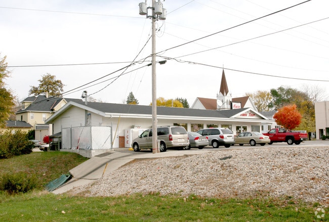
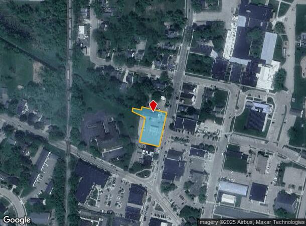
Property Record
135 N Main St, Deerfield, WI 53531
NEARBY LISTINGS FOR SALE OR LEASE
-
-
View all Deerfield listings for sale on LoopNet.com
Property Detail
135 N Main St
Madison, WI
William Bedfords Addn
0509-122-2008-3
WILLIAM BEDFORDS ADDN LOTS 8, 9, 10, 11, 12 & PRT LOT 13 BLOCK 2 & PRT LOT 30 BL OCK 4 DESCR AS COM SE COR ASSRS PLAT 2 VILLAGE OF OREGON TH N11DEG1500E 216.27 FT ALG E LN SD PLAT TO POB TH N78DEG0900W 115.38 FT TH N11DEG1500E 143.26 F T TH N65DEG460
Commercialnec
Dane
AE
Wisconsin
55025C0592H
08
2024
0.56 AC
2024
Outlying Dane West
011900
Milwaukee/Madison
DEMOGRAPHICS near 135 N Main St
1 Mile
3 Mile
5 Mile
2024 Total Population
8,326
14,536
20,130
2029 Population
8,641
15,094
20,820
Pop Growth 2024-2029
+ 3.78%
+ 3.84%
+ 3.43%
Average Age
39
40
40
2024 Total Households
3,314
5,454
7,664
HH Growth 2024-2029
+ 3.83%
+ 3.91%
+ 3.51%
Median Household Inc
$92,908
$97,532
$99,135
Avg Household Size
2.50
2.50
2.50
2024 Avg HH Vehicles
2.00
2.00
2.00
Median Home Value
$327,259
$342,106
$353,912
Median Year Built
1990
1991
1990
Nearby Places
Map Layers
Map Styles
 Street
 Aerial
- Restaurants
- Banks
- Shops
- Fitness
- Groceries
PUBLIC TRANSPORTATION
AIRPORT
Dane County Regional/Truax Field
DRIVE
WALK
Distance
Dane County Regional/Truax Field
31 min
16.9 mi
Nearby Properties
Address
Land Use
TOTAL SIZE
Lot Size
Zoning
Address
Land Use
TOTAL SIZE
Lot Size
Zoning
10.41 AC
Address
Land Use
TOTAL SIZE
Lot Size
Zoning
2.28 AC
Address
Land Use
TOTAL SIZE
Lot Size
Zoning
10.46 AC
Address
Land Use
TOTAL SIZE
Lot Size
Zoning
1.27 AC
Address
Land Use
TOTAL SIZE
Lot Size
Zoning
4.75 AC
Address
Land Use
TOTAL SIZE
Lot Size
Zoning
2.39 AC
Address
Land Use
TOTAL SIZE
Lot Size
Zoning
2.57 AC
A3
Address
Land Use
TOTAL SIZE
Lot Size
Zoning
11.10 AC
Address
Land Use
TOTAL SIZE
Lot Size
Zoning
18.58 AC
RE-1
Address
Land Use
TOTAL SIZE
Lot Size
Zoning
1.55 AC
Address
Land Use
TOTAL SIZE
Lot Size
Zoning
16.34 AC
A3
Address
Land Use
TOTAL SIZE
Lot Size
Zoning
11.29 AC
Address
Land Use
TOTAL SIZE
Lot Size
Zoning
4.33 AC
A3
Address
Land Use
TOTAL SIZE
Lot Size
Zoning
10.29 AC
Address
Land Use
TOTAL SIZE
Lot Size
Zoning
2.45 AC
A3
Address
Land Use
TOTAL SIZE
Lot Size
Zoning
0.99 AC
Address
Land Use
TOTAL SIZE
Lot Size
Zoning
3.03 AC
Address
Land Use
TOTAL SIZE
Lot Size
Zoning
2.85 AC
Address
Land Use
TOTAL SIZE
Lot Size
Zoning
0.81 AC
Address
Land Use
TOTAL SIZE
Lot Size
Zoning
4.86 AC
Address
Land Use
TOTAL SIZE
Lot Size
Zoning
2.68 AC
Address
Land Use
TOTAL SIZE
Lot Size
Zoning
1.59 AC
Address
Land Use
TOTAL SIZE
Lot Size
Zoning
1.94 AC
A3
Address
Land Use
TOTAL SIZE
Lot Size
Zoning
2.60 AC
A-1EX
Address
Land Use
TOTAL SIZE
Lot Size
Zoning
2.58 AC
Address
Land Use
TOTAL SIZE
Lot Size
Zoning
0.80 AC
Address
Land Use
TOTAL SIZE
Lot Size
Zoning
0.64 AC
Address
Land Use
TOTAL SIZE
Lot Size
Zoning
1.65 AC
Address
Land Use
TOTAL SIZE
Lot Size
Zoning
1.33 AC
Address
Land Use
TOTAL SIZE
Lot Size
Zoning
1.47 AC
The World's #1 Commercial Real Estate Marketplace
Connect with us
© 2025 CoStar Group
The information above has been obtained from sources believed reliable. While we do not doubt its accuracy we have not verified it and make no guarantee, warranty or representation about it. It is your responsibility to independently confirm its accuracy and completeness. Any projections, opinions, assumptions, or estimates used are for example only and do not represent the current or future performance of the property. The value of this transaction to you depends on tax and other factors which should be evaluated by your tax, financial, and legal advisors. You and your advisors should conduct a careful, independent investigation of the property to determine to your satisfaction the suitability of the property for your needs.