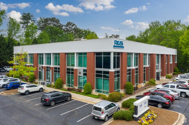
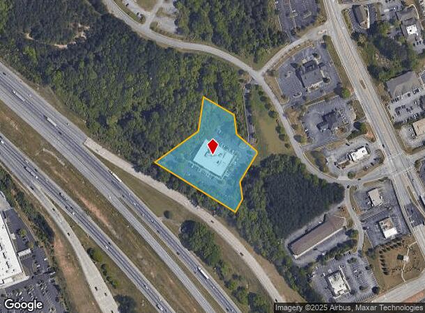
Property Record
135 N Park Pl, Stockbridge, GA 30281


NEARBY LISTINGS FOR SALE OR LEASE
Property Detail
135 N Park Pl
Atlanta-Sandy Springs-Roswell, GA
North Park 01
0032-01-030-016
LAND LOT: 13 /LAND DISTRICT: 6; COMMERCIAL
Officebuilding
Henry
X
Georgia
13151C0088D
13
2025
2.60 AC
2025
South Clayton/Henry Cnty
070113
Atlanta
33,376 SF
DEMOGRAPHICS near 135 N Park Pl
1 Mile
3 Mile
5 Mile
2024 Total Population
5,641
42,031
101,461
2029 Population
6,060
45,497
108,865
Pop Growth 2024-2029
+ 7.43%
+ 8.25%
+ 7.30%
Average Age
39
38
38
2024 Total Households
2,292
15,279
36,071
HH Growth 2024-2029
+ 7.50%
+ 8.23%
+ 7.22%
Median Household Inc
$58,466
$69,623
$73,530
Avg Household Size
2.40
2.70
2.80
2024 Avg HH Vehicles
2.00
2.00
2.00
Median Home Value
$220,542
$223,914
$237,730
Median Year Built
1994
1995
1996
Nearby Places
Map Layers
Map Styles
 Street
 Aerial
- Restaurants
- Banks
- Shops
- Fitness
- Groceries
PUBLIC TRANSPORTATION
AIRPORT
Hartsfield - Jackson Atlanta International
DRIVE
WALK
Distance
Hartsfield - Jackson Atlanta International
25 min
17.3 mi
SALE & LEASE HISTORY
LISTING DATE
SALE/LEASE

Sep 15, 2017
For Lease
May 15, 2017
For Sale
Jan 16, 2019
For Sale
Jan 06, 2022
For Lease
Feb 22, 2017
For Sale
Feb 12, 2019
For Lease
Aug 16, 2018
For Lease
Nearby Properties
Address
Land Use
TOTAL SIZE
Lot Size
Zoning
Address
Land Use
TOTAL SIZE
Lot Size
Zoning
27,850 SF
15.19 AC
Address
Land Use
TOTAL SIZE
Lot Size
Zoning
22,400 SF
45.37 AC
RM
Address
Land Use
TOTAL SIZE
Lot Size
Zoning
476,716 SF
28.93 AC
C2
Address
Land Use
TOTAL SIZE
Lot Size
Zoning
30,396 SF
21.12 AC
Address
Land Use
TOTAL SIZE
Lot Size
Zoning
4,010 SF
37.60 AC
C2
Address
Land Use
TOTAL SIZE
Lot Size
Zoning
17,862 SF
30 AC
PD
Address
Land Use
TOTAL SIZE
Lot Size
Zoning
19,140 SF
40.11 AC
RM
Address
Land Use
TOTAL SIZE
Lot Size
Zoning
21,678 SF
26.44 AC
RM
Address
Land Use
TOTAL SIZE
Lot Size
Zoning
13,072 SF
32.50 AC
RM
Address
Land Use
TOTAL SIZE
Lot Size
Zoning
707,800 SF
27.81 AC
M1
Address
Land Use
TOTAL SIZE
Lot Size
Zoning
25,952 SF
28.88 AC
RM
Address
Land Use
TOTAL SIZE
Lot Size
Zoning
9,264 SF
26.63 AC
RM
Address
Land Use
TOTAL SIZE
Lot Size
Zoning
510,053 SF
39.93 AC
M1
Address
Land Use
TOTAL SIZE
Lot Size
Zoning
25,508 SF
26.03 AC
RM
Address
Land Use
TOTAL SIZE
Lot Size
Zoning
127,960 SF
93.84 AC
RA
Address
Land Use
TOTAL SIZE
Lot Size
Zoning
439,225 SF
19.81 AC
M1
Address
Land Use
TOTAL SIZE
Lot Size
Zoning
72,898 SF
24 AC
C3
Address
Land Use
TOTAL SIZE
Lot Size
Zoning
399,189 SF
29.60 AC
M1
Address
Land Use
TOTAL SIZE
Lot Size
Zoning
269,100 SF
30.64 AC
Address
Land Use
TOTAL SIZE
Lot Size
Zoning
425,476 SF
58.85 AC
PD
Address
Land Use
TOTAL SIZE
Lot Size
Zoning
74,395 SF
49.35 AC
PD
Address
Land Use
TOTAL SIZE
Lot Size
Zoning
111,398 SF
15.54 AC
C2
Address
Land Use
TOTAL SIZE
Lot Size
Zoning
653,368 SF
17.84 AC
Address
Land Use
TOTAL SIZE
Lot Size
Zoning
68,500 SF
140.42 AC
R2
Address
Land Use
TOTAL SIZE
Lot Size
Zoning
216,361 SF
27.44 AC
C3
Address
Land Use
TOTAL SIZE
Lot Size
Zoning
175,828 SF
19.77 AC
C3
Address
Land Use
TOTAL SIZE
Lot Size
Zoning
1,638 SF
12.79 AC
RM
Address
Land Use
TOTAL SIZE
Lot Size
Zoning
62,142 SF
4.36 AC
C1
Address
Land Use
TOTAL SIZE
Lot Size
Zoning
70.85 AC
C2
Address
Land Use
TOTAL SIZE
Lot Size
Zoning
54,056 SF
10.40 AC
OI
The World's #1 Commercial Real Estate Marketplace
Connect with us
© 2025 CoStar Group
The information above has been obtained from sources believed reliable. While we do not doubt its accuracy we have not verified it and make no guarantee, warranty or representation about it. It is your responsibility to independently confirm its accuracy and completeness. Any projections, opinions, assumptions, or estimates used are for example only and do not represent the current or future performance of the property. The value of this transaction to you depends on tax and other factors which should be evaluated by your tax, financial, and legal advisors. You and your advisors should conduct a careful, independent investigation of the property to determine to your satisfaction the suitability of the property for your needs.