Property Record
135 N Walnut St, Augusta, KS 67010
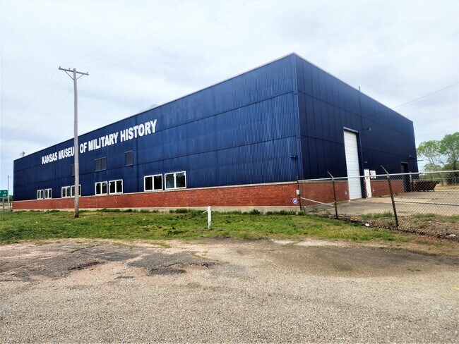

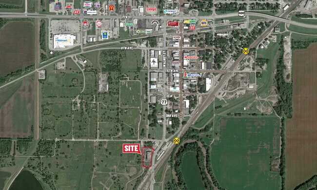
Property Detail
135 N Walnut St
Wichita, KS
S27, T27, R04E, ACRES 1.7, BEG 131.5W 172.3S NE/C SW4 S12 SELY63.7 SWLY345 SW70.9 NW115 N379.6 E187.4 TO POB (SCALED)
298-27-0-00-00-001-04-0
Butler
Heavyindustrial
Kansas
0
1.70 AC
2025
Augusta/El Dorado
020204
Wichita
16,200 SF
NEARBY LISTINGS FOR SALE OR LEASE
-
-
View all Augusta listings for lease on LoopNet.com
DEMOGRAPHICS near 135 N Walnut St
1 mile
3 mile
5 mile
2025 Total Population
1,943
9,176
12,334
2030 Population
2,008
9,314
12,505
Pop Growth 2025-2030
+ 3.35%
+ 1.50%
+ 1.39%
Average Age
37
40
41
2025 Total Households
800
3,694
4,841
HH Growth 2025-2030
+ 3.50%
+ 1.62%
+ 1.49%
Median Household Inc
$46,944
$55,324
$63,890
Avg Household Size
2.40
2.40
2.50
2025 Avg HH Vehicles
2.00
2.00
2.00
Median Home Value
$115,454
$155,555
$188,148
Median Year Built
1969
1972
1977
Nearby Places
Map Layers
Map Styles
 Street
 Aerial
Layers
 Traffic
 Biking
Places
Listings with unknown addresses are not visible on the map
- Restaurants
- Banks
- Shops
- Fitness
- Groceries
PUBLIC TRANSPORTATION
AIRPORT
Wichita Dwight D Eisenhower Ntl
Drive
Walk
Distance
Wichita Dwight D Eisenhower Ntl
37 min
26.6 mi
Freight Ports
Tulsa Port Of Catoosa
Drive
Walk
Distance
Tulsa Port Of Catoosa
214 min
179.9 mi
SALE & LEASE HISTORY
LISTING DATE
SALE/LEASE

Sep 15, 2023
For Lease
Sep 15, 2023
For Sale
Nearby Properties
Address
Land Use
TOTAL SIZE
Lot Size
Zoning
Address
Land Use
TOTAL SIZE
Lot Size
Zoning
5.10 AC
Address
Land Use
TOTAL SIZE
Lot Size
Zoning
42.50 AC
Address
Land Use
TOTAL SIZE
Lot Size
Zoning
Address
Land Use
TOTAL SIZE
Lot Size
Zoning
28,587 SF
5 AC
Address
Land Use
TOTAL SIZE
Lot Size
Zoning
20.90 AC
Address
Land Use
TOTAL SIZE
Lot Size
Zoning
4.80 AC
Address
Land Use
TOTAL SIZE
Lot Size
Zoning
45,938 SF
5 AC
Address
Land Use
TOTAL SIZE
Lot Size
Zoning
8.40 AC
Address
Land Use
TOTAL SIZE
Lot Size
Zoning
32,876 SF
1.40 AC
Address
Land Use
TOTAL SIZE
Lot Size
Zoning
6.50 AC
Address
Land Use
TOTAL SIZE
Lot Size
Zoning
3.30 AC
Address
Land Use
TOTAL SIZE
Lot Size
Zoning
15,136 SF
10.10 AC
Address
Land Use
TOTAL SIZE
Lot Size
Zoning
120,432 SF
15 AC
Address
Land Use
TOTAL SIZE
Lot Size
Zoning
3.20 AC
Address
Land Use
TOTAL SIZE
Lot Size
Zoning
3,000 SF
6.30 AC
Address
Land Use
TOTAL SIZE
Lot Size
Zoning
2,804 SF
3.70 AC
Address
Land Use
TOTAL SIZE
Lot Size
Zoning
213.40 AC
Address
Land Use
TOTAL SIZE
Lot Size
Zoning
32,047 SF
1.10 AC
Address
Land Use
TOTAL SIZE
Lot Size
Zoning
12.30 AC
Address
Land Use
TOTAL SIZE
Lot Size
Zoning
0.90 AC
Address
Land Use
TOTAL SIZE
Lot Size
Zoning
4,743 SF
0.99 AC
Address
Land Use
TOTAL SIZE
Lot Size
Zoning
40,670 SF
5.20 AC
Address
Land Use
TOTAL SIZE
Lot Size
Zoning
1,440 SF
34 AC
Address
Land Use
TOTAL SIZE
Lot Size
Zoning
6.10 AC
Address
Land Use
TOTAL SIZE
Lot Size
Zoning
6.40 AC
Address
Land Use
TOTAL SIZE
Lot Size
Zoning
1,457 SF
6 AC
Address
Land Use
TOTAL SIZE
Lot Size
Zoning
12,342 SF
5.30 AC
Address
Land Use
TOTAL SIZE
Lot Size
Zoning
74,656 SF
2.60 AC
Address
Land Use
TOTAL SIZE
Lot Size
Zoning
16,359 SF
0.76 AC
Address
Land Use
TOTAL SIZE
Lot Size
Zoning
9,800 SF
3.20 AC
The World's #1 Commercial Real Estate Marketplace
Connect with us
© 2026 CoStar Group
The information above has been obtained from sources believed reliable. While we do not doubt its accuracy we have not verified it and make no guarantee, warranty or representation about it. It is your responsibility to independently confirm its accuracy and completeness. Any projections, opinions, assumptions, or estimates used are for example only and do not represent the current or future performance of the property. The value of this transaction to you depends on tax and other factors which should be evaluated by your tax, financial, and legal advisors. You and your advisors should conduct a careful, independent investigation of the property to determine to your satisfaction the suitability of the property for your needs.