Property Record
135 New Rd, Madison, CT 06443
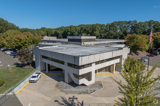

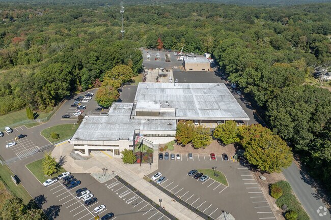
Property Detail
135 New Rd
Officebuilding
NEW HAVEN
RU-2
Connecticut
B and X Area of moderate flood hazard, usually the area between the limits of the 100-year and 500-year floods.
37.98 AC
2024
Guilford
2025
Westchester/So Connecticut
194202
New Haven, CT
37,619 SF
MADI-000060-000000-000008
NEARBY LISTINGS FOR SALE OR LEASE
DEMOGRAPHICS near 135 New Rd
1 mile
3 mile
5 mile
2025 Total Population
2,829
19,048
36,283
2030 Population
2,904
19,580
37,183
Pop Growth 2025-2030
+ 2.65%
+ 2.79%
+ 2.48%
Average Age
47
47
47
2025 Total Households
1,116
7,901
14,901
HH Growth 2025-2030
+ 2.69%
+ 2.91%
+ 2.64%
Median Household Inc
$142,762
$127,087
$125,935
Avg Household Size
2.50
2.40
2.40
2025 Avg HH Vehicles
2.00
2.00
2.00
Median Home Value
$527,845
$497,363
$503,392
Median Year Built
1976
1971
1972
Nearby Places
Map Layers
Map Styles
 Street
 Aerial
Layers
 Traffic
 Biking
Places
Listings with unknown addresses are not visible on the map
- Restaurants
- Banks
- Shops
- Fitness
- Groceries
PUBLIC TRANSPORTATION
COMMUTER RAIL
Madison (Shore Line East - Shore Line East)
Drive
Walk
Distance
Madison (Shore Line East - Shore Line East)
5 min
1.7 mi
Drive
Walk
Distance
7 min
3.4 mi
AIRPORT
Tweed/New Haven
Drive
Walk
Distance
Tweed/New Haven
26 min
18.2 mi
Freight Ports
Port of New Haven
Drive
Walk
Distance
Port of New Haven
26 min
18.8 mi
Nearby Properties
Address
Land Use
TOTAL SIZE
Lot Size
Zoning
Address
Land Use
TOTAL SIZE
Lot Size
Zoning
158,618 SF
72.20 AC
RU-2
Address
Land Use
TOTAL SIZE
Lot Size
Zoning
47.11 AC
Address
Land Use
TOTAL SIZE
Lot Size
Zoning
138,909 SF
41.60 AC
R-20
Address
Land Use
TOTAL SIZE
Lot Size
Zoning
87,717 SF
12 AC
Address
Land Use
TOTAL SIZE
Lot Size
Zoning
6,026 SF
45 AC
R-2
Address
Land Use
TOTAL SIZE
Lot Size
Zoning
22,590 SF
54.72 AC
RU-2
Address
Land Use
TOTAL SIZE
Lot Size
Zoning
98,963 SF
49.97 AC
Address
Land Use
TOTAL SIZE
Lot Size
Zoning
45,025 SF
0.93 AC
R-5
Address
Land Use
TOTAL SIZE
Lot Size
Zoning
540 SF
8.25 AC
C
Address
Land Use
TOTAL SIZE
Lot Size
Zoning
54,375 SF
7.01 AC
Address
Land Use
TOTAL SIZE
Lot Size
Zoning
12,945 SF
15.20 AC
R-2
Address
Land Use
TOTAL SIZE
Lot Size
Zoning
60,070 SF
5.89 AC
DC
Address
Land Use
TOTAL SIZE
Lot Size
Zoning
37,379 SF
1.43 AC
D
Address
Land Use
TOTAL SIZE
Lot Size
Zoning
822 SF
6 AC
R-2
Address
Land Use
TOTAL SIZE
Lot Size
Zoning
17,317 SF
5 AC
RU-2
Address
Land Use
TOTAL SIZE
Lot Size
Zoning
7,527 SF
71.77 AC
R-1
Address
Land Use
TOTAL SIZE
Lot Size
Zoning
6,535 SF
12.68 AC
R-2
Address
Land Use
TOTAL SIZE
Lot Size
Zoning
56,608 SF
1.27 AC
I-1
Address
Land Use
TOTAL SIZE
Lot Size
Zoning
3,872 SF
49.73 AC
R-80
Address
Land Use
TOTAL SIZE
Lot Size
Zoning
3,996 SF
5.43 AC
R-2
Address
Land Use
TOTAL SIZE
Lot Size
Zoning
5.56 AC
Address
Land Use
TOTAL SIZE
Lot Size
Zoning
3,077 SF
2.86 AC
T
Address
Land Use
TOTAL SIZE
Lot Size
Zoning
36,623 SF
5.13 AC
R-2
Address
Land Use
TOTAL SIZE
Lot Size
Zoning
9.32 AC
M-1
Address
Land Use
TOTAL SIZE
Lot Size
Zoning
30,922 SF
1.23 AC
C
Address
Land Use
TOTAL SIZE
Lot Size
Zoning
5,074 SF
1.30 AC
D
Address
Land Use
TOTAL SIZE
Lot Size
Zoning
640 SF
3 AC
T
Address
Land Use
TOTAL SIZE
Lot Size
Zoning
25,080 SF
2.77 AC
B-3
Address
Land Use
TOTAL SIZE
Lot Size
Zoning
928 SF
2.60 AC
R-2
The World's #1 Commercial Real Estate Marketplace
Connect with us
© 2026 CoStar Group
The information above has been obtained from sources believed reliable. While we do not doubt its accuracy we have not verified it and make no guarantee, warranty or representation about it. It is your responsibility to independently confirm its accuracy and completeness. Any projections, opinions, assumptions, or estimates used are for example only and do not represent the current or future performance of the property. The value of this transaction to you depends on tax and other factors which should be evaluated by your tax, financial, and legal advisors. You and your advisors should conduct a careful, independent investigation of the property to determine to your satisfaction the suitability of the property for your needs.