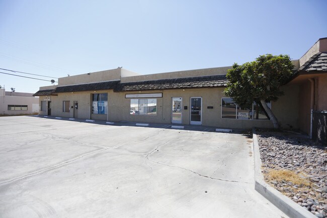
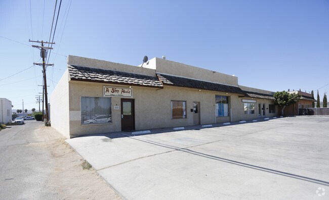
Property Record
135 Panamint Ave, Ridgecrest, CA 93555

Save to a Folder
{{folder.Name}}
{{folder.ListingIds.length}} Properties
{{folder.ListingIds.length}} Property
Create a New Folder
Property Detail
135 Panamint Ave
Bakersfield-Delano, CA
TRACT 1440 , BLOCK &18, LOT 17
067-150-42-00-3
KERN
Storebuilding
California
B and X Area of moderate flood hazard, usually the area between the limits of the 100-year and 500-year floods.
17
2025
0.30 AC
2025
NE Outlying Kern County
005402
Bakersfield
3,600 SF
NEARBY LISTINGS FOR SALE OR LEASE
DEMOGRAPHICS near 135 Panamint Ave
1 mile
3 mile
5 mile
2025 Total Population
12,108
33,804
35,168
2030 Population
12,520
34,979
36,396
Pop Growth 2025-2030
+ 3.40%
+ 3.48%
+ 3.49%
Average Age
36
38
38
2025 Total Households
4,980
13,659
14,155
HH Growth 2025-2030
+ 3.33%
+ 3.47%
+ 3.49%
Median Household Inc
$78,531
$85,915
$85,671
Avg Household Size
2.40
2.40
2.40
2025 Avg HH Vehicles
2.00
2.00
2.00
Median Home Value
$248,913
$274,672
$275,974
Median Year Built
1978
1981
1981
Nearby Places
Map Layers
Map Styles
 Street
 Aerial
Layers
 Traffic
 Biking
Places
Listings with unknown addresses are not visible on the map
- Restaurants
- Banks
- Shops
- Fitness
- Groceries
SALE & LEASE HISTORY
LISTING DATE
SALE/LEASE

Sep 01, 2017
For Lease
Nearby Properties
Address
Land Use
TOTAL SIZE
Lot Size
Zoning
Address
Land Use
TOTAL SIZE
Lot Size
Zoning
24,013 SF
7.01 AC
Address
Land Use
TOTAL SIZE
Lot Size
Zoning
58,542 SF
2.85 AC
CS
Address
Land Use
TOTAL SIZE
Lot Size
Zoning
25,800 SF
2.38 AC
PO
Address
Land Use
TOTAL SIZE
Lot Size
Zoning
80,620 SF
2.51 AC
CG
Address
Land Use
TOTAL SIZE
Lot Size
Zoning
58,053 SF
2.77 AC
CS
Address
Land Use
TOTAL SIZE
Lot Size
Zoning
68,077 SF
9 AC
GC
Address
Land Use
TOTAL SIZE
Lot Size
Zoning
14,738 SF
4.21 AC
Address
Land Use
TOTAL SIZE
Lot Size
Zoning
2.58 AC
PO
Address
Land Use
TOTAL SIZE
Lot Size
Zoning
3,630 SF
6.09 AC
Address
Land Use
TOTAL SIZE
Lot Size
Zoning
16,992 SF
1.56 AC
GC
Address
Land Use
TOTAL SIZE
Lot Size
Zoning
71,334 SF
3.61 AC
C
Address
Land Use
TOTAL SIZE
Lot Size
Zoning
36,774 SF
3.30 AC
GC
Address
Land Use
TOTAL SIZE
Lot Size
Zoning
10,608 SF
5.44 AC
R-3
Address
Land Use
TOTAL SIZE
Lot Size
Zoning
31,770 SF
2.19 AC
PUD
Address
Land Use
TOTAL SIZE
Lot Size
Zoning
14,516 SF
1.67 AC
C2
Address
Land Use
TOTAL SIZE
Lot Size
Zoning
43,610 SF
3.78 AC
Address
Land Use
TOTAL SIZE
Lot Size
Zoning
59,832 SF
3.99 AC
R2
Address
Land Use
TOTAL SIZE
Lot Size
Zoning
45,689 SF
3.68 AC
GC
Address
Land Use
TOTAL SIZE
Lot Size
Zoning
16,629 SF
3.59 AC
Address
Land Use
TOTAL SIZE
Lot Size
Zoning
12,272 SF
7.27 AC
R-3
Address
Land Use
TOTAL SIZE
Lot Size
Zoning
58,549 SF
4.94 AC
GC
Address
Land Use
TOTAL SIZE
Lot Size
Zoning
Address
Land Use
TOTAL SIZE
Lot Size
Zoning
2,100 SF
12.68 AC
M1
Address
Land Use
TOTAL SIZE
Lot Size
Zoning
15,875 SF
5.68 AC
CN R1
Address
Land Use
TOTAL SIZE
Lot Size
Zoning
25,144 SF
11.79 AC
E2
Address
Land Use
TOTAL SIZE
Lot Size
Zoning
22,840 SF
0.83 AC
CH
Address
Land Use
TOTAL SIZE
Lot Size
Zoning
17,740 SF
1.85 AC
Address
Land Use
TOTAL SIZE
Lot Size
Zoning
12,361 SF
1.48 AC
CG
Address
Land Use
TOTAL SIZE
Lot Size
Zoning
22,148 SF
1.48 AC
C1
Address
Land Use
TOTAL SIZE
Lot Size
Zoning
1,202 SF
4 AC
R-2
The World's #1 Commercial Real Estate Marketplace
Connect with us
© 2026 CoStar Group
The information above has been obtained from sources believed reliable. While we do not doubt its accuracy we have not verified it and make no guarantee, warranty or representation about it. It is your responsibility to independently confirm its accuracy and completeness. Any projections, opinions, assumptions, or estimates used are for example only and do not represent the current or future performance of the property. The value of this transaction to you depends on tax and other factors which should be evaluated by your tax, financial, and legal advisors. You and your advisors should conduct a careful, independent investigation of the property to determine to your satisfaction the suitability of the property for your needs.