Property Record
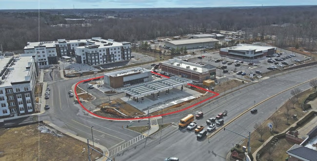
135 Rosewick Corner Pl, La Plata, MD 20646

Property Detail
135 Rosewick Corner Pl
Washington-Arlington-Alexandria, DC-VA-MD-WV
UNIT 3 = 1.532 AC ROSEWICK CORNER CONDOMIN
06-360407
CHARLES
Storebuilding
Maryland
CH
1.53 AC
2025
Charles County
2025
Washington, DC
851004
NEARBY LISTINGS FOR SALE OR LEASE
DEMOGRAPHICS near 135 Rosewick Corner Pl
1 mile
3 mile
5 mile
2025 Total Population
1,069
19,224
60,704
2030 Population
1,140
20,296
63,295
Pop Growth 2025-2030
+ 6.64%
+ 5.58%
+ 4.27%
Average Age
44
41
39
2025 Total Households
407
6,985
21,489
HH Growth 2025-2030
+ 6.88%
+ 5.86%
+ 4.42%
Median Household Inc
$88,876
$104,162
$112,661
Avg Household Size
2.60
2.70
2.80
2025 Avg HH Vehicles
2.00
2.00
2.00
Median Home Value
$347,154
$414,103
$432,933
Median Year Built
1983
1997
1998
Nearby Places
Map Layers
Map Styles
 Street
 Aerial
Transit
 Traffic
 Biking
Places
Listings with unknown addresses are not visible on the map
- Restaurants
- Banks
- Shops
- Fitness
- Groceries
PUBLIC TRANSPORTATION
AIRPORT
Ronald Reagan Washington Ntl
Drive
Walk
Distance
Ronald Reagan Washington Ntl
56 min
34.0 mi
SALE & LEASE HISTORY
LISTING DATE
SALE/LEASE

Feb 13, 2025
For Sale
Nearby Properties
Address
Land Use
TOTAL SIZE
Lot Size
Zoning
Address
Land Use
TOTAL SIZE
Lot Size
Zoning
173.69 AC
RC
Address
Land Use
TOTAL SIZE
Lot Size
Zoning
273,438 SF
6.25 AC
CH
Address
Land Use
TOTAL SIZE
Lot Size
Zoning
315,662 SF
134.30 AC
PL
Address
Land Use
TOTAL SIZE
Lot Size
Zoning
150,480 SF
4.60 AC
CH
Address
Land Use
TOTAL SIZE
Lot Size
Zoning
141,769 SF
89.68 AC
RC
Address
Land Use
TOTAL SIZE
Lot Size
Zoning
113,605 SF
20.59 AC
CH
Address
Land Use
TOTAL SIZE
Lot Size
Zoning
6.54 AC
PL
Address
Land Use
TOTAL SIZE
Lot Size
Zoning
80,682 SF
11.35 AC
C-H
Address
Land Use
TOTAL SIZE
Lot Size
Zoning
98,995 SF
16.83 AC
NCX
Address
Land Use
TOTAL SIZE
Lot Size
Zoning
53,638 SF
3.76 AC
MUD-3
Address
Land Use
TOTAL SIZE
Lot Size
Zoning
129,001 SF
11.64 AC
C-H
Address
Land Use
TOTAL SIZE
Lot Size
Zoning
15.22 AC
TDX
Address
Land Use
TOTAL SIZE
Lot Size
Zoning
166,188 SF
27.99 AC
IG
Address
Land Use
TOTAL SIZE
Lot Size
Zoning
137,862 SF
18.10 AC
CH
Address
Land Use
TOTAL SIZE
Lot Size
Zoning
174,315 SF
90 AC
RC
Address
Land Use
TOTAL SIZE
Lot Size
Zoning
106,711 SF
92.18 AC
PL
Address
Land Use
TOTAL SIZE
Lot Size
Zoning
65,890 SF
6.70 AC
PL
Address
Land Use
TOTAL SIZE
Lot Size
Zoning
35,976 SF
3.97 AC
CH
Address
Land Use
TOTAL SIZE
Lot Size
Zoning
62,127 SF
37.47 AC
PL
Address
Land Use
TOTAL SIZE
Lot Size
Zoning
44,620 SF
9 AC
R-10
Address
Land Use
TOTAL SIZE
Lot Size
Zoning
93,267 SF
6.12 AC
CC
Address
Land Use
TOTAL SIZE
Lot Size
Zoning
6,400 SF
115.16 AC
BP
Address
Land Use
TOTAL SIZE
Lot Size
Zoning
70,913 SF
6.02 AC
CH
Address
Land Use
TOTAL SIZE
Lot Size
Zoning
75,375 SF
4.34 AC
C-B
Address
Land Use
TOTAL SIZE
Lot Size
Zoning
140,188 SF
15 AC
CH
Address
Land Use
TOTAL SIZE
Lot Size
Zoning
40,904 SF
25.97 AC
RR
Address
Land Use
TOTAL SIZE
Lot Size
Zoning
98,400 SF
1.89 AC
PL
Address
Land Use
TOTAL SIZE
Lot Size
Zoning
89,000 SF
2.13 AC
CB
Address
Land Use
TOTAL SIZE
Lot Size
Zoning
68,859 SF
3.75 AC
MUD-3
Address
Land Use
TOTAL SIZE
Lot Size
Zoning
3,696 SF
578.77 AC
MUD-3
The World's #1 Commercial Real Estate Marketplace
Connect with us
© 2026 CoStar Group
The information above has been obtained from sources believed reliable. While we do not doubt its accuracy we have not verified it and make no guarantee, warranty or representation about it. It is your responsibility to independently confirm its accuracy and completeness. Any projections, opinions, assumptions, or estimates used are for example only and do not represent the current or future performance of the property. The value of this transaction to you depends on tax and other factors which should be evaluated by your tax, financial, and legal advisors. You and your advisors should conduct a careful, independent investigation of the property to determine to your satisfaction the suitability of the property for your needs.