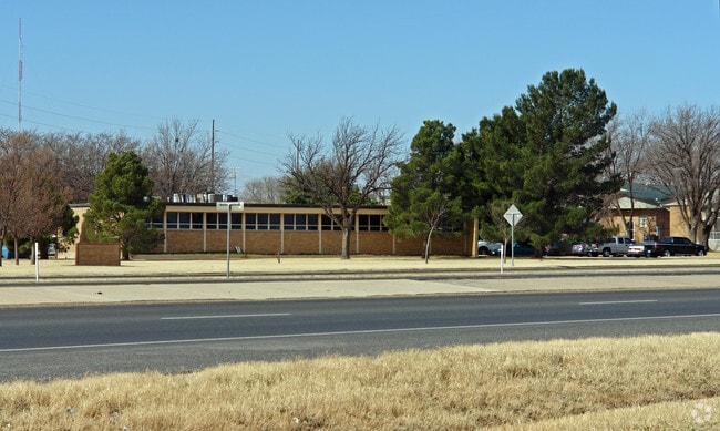
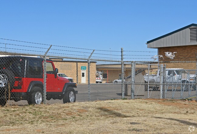
Property Record
135 Slaton Rd, Lubbock, TX 79404

Property Detail
135 Slaton Rd
Lubbock, TX
TEXAS DEPT OF TRANSPORTATION TR A
R78576
LUBBOCK
Taxexempt
Texas
B and X Area of moderate flood hazard, usually the area between the limits of the 100-year and 500-year floods.
18.21 AC
0
Southeast Inner Loop
2025
Lubbock
002500
NEARBY LISTINGS FOR SALE OR LEASE
DEMOGRAPHICS near 135 Slaton Rd
1 mile
3 mile
5 mile
2024 Total Population
7,146
63,214
153,686
2029 Population
7,469
65,887
160,136
Pop Growth 2024-2029
+ 4.52%
+ 4.23%
+ 4.20%
Average Age
35
36
36
2024 Total Households
2,591
24,327
58,618
HH Growth 2024-2029
+ 4.79%
+ 4.44%
+ 4.66%
Median Household Inc
$50,843
$50,959
$52,777
Avg Household Size
2.70
2.50
2.40
2024 Avg HH Vehicles
2.00
2.00
2.00
Median Home Value
$118,392
$152,603
$186,383
Median Year Built
1968
1973
1977
Nearby Places
Map Layers
Map Styles
 Street
 Aerial
Transit
 Traffic
 Biking
Places
Listings with unknown addresses are not visible on the map
- Restaurants
- Banks
- Shops
- Fitness
- Groceries
PUBLIC TRANSPORTATION
AIRPORT
Lubbock Preston Smith International
Drive
Walk
Distance
Lubbock Preston Smith International
25 min
14.7 mi
Freight Ports
Tulsa Port Of Catoosa
Drive
Walk
Distance
Tulsa Port Of Catoosa
508 min
470.7 mi
Nearby Properties
Address
Land Use
TOTAL SIZE
Lot Size
Zoning
Address
Land Use
TOTAL SIZE
Lot Size
Zoning
709,350 SF
98.60 AC
Address
Land Use
TOTAL SIZE
Lot Size
Zoning
176,165 SF
36.61 AC
Address
Land Use
TOTAL SIZE
Lot Size
Zoning
219,352 SF
21.90 AC
Address
Land Use
TOTAL SIZE
Lot Size
Zoning
7.68 AC
Address
Land Use
TOTAL SIZE
Lot Size
Zoning
167,208 SF
10.09 AC
Address
Land Use
TOTAL SIZE
Lot Size
Zoning
157,644 SF
9.69 AC
Address
Land Use
TOTAL SIZE
Lot Size
Zoning
76,680 SF
4.95 AC
Address
Land Use
TOTAL SIZE
Lot Size
Zoning
88,998 SF
7.56 AC
Address
Land Use
TOTAL SIZE
Lot Size
Zoning
421,200 SF
43.22 AC
Address
Land Use
TOTAL SIZE
Lot Size
Zoning
119,200 SF
8.44 AC
Address
Land Use
TOTAL SIZE
Lot Size
Zoning
205,150 SF
23.43 AC
Address
Land Use
TOTAL SIZE
Lot Size
Zoning
133,795 SF
6.37 AC
Address
Land Use
TOTAL SIZE
Lot Size
Zoning
71,329 SF
14 AC
Address
Land Use
TOTAL SIZE
Lot Size
Zoning
150,000 SF
216.67 AC
Address
Land Use
TOTAL SIZE
Lot Size
Zoning
71,413 SF
5.42 AC
Address
Land Use
TOTAL SIZE
Lot Size
Zoning
105,908 SF
9.78 AC
Address
Land Use
TOTAL SIZE
Lot Size
Zoning
24,084 SF
2.44 AC
Address
Land Use
TOTAL SIZE
Lot Size
Zoning
192,128 SF
9.87 AC
Address
Land Use
TOTAL SIZE
Lot Size
Zoning
121,899 SF
7.70 AC
Address
Land Use
TOTAL SIZE
Lot Size
Zoning
53,816 SF
1.32 AC
Address
Land Use
TOTAL SIZE
Lot Size
Zoning
42,288 SF
5.30 AC
Address
Land Use
TOTAL SIZE
Lot Size
Zoning
131,497 SF
4.61 AC
Address
Land Use
TOTAL SIZE
Lot Size
Zoning
189,737 SF
31 AC
Address
Land Use
TOTAL SIZE
Lot Size
Zoning
88,310 SF
9.95 AC
Address
Land Use
TOTAL SIZE
Lot Size
Zoning
367,283 SF
36.77 AC
Address
Land Use
TOTAL SIZE
Lot Size
Zoning
113,156 SF
6.82 AC
Address
Land Use
TOTAL SIZE
Lot Size
Zoning
86,190 SF
6.60 AC
Address
Land Use
TOTAL SIZE
Lot Size
Zoning
137,554 SF
8.50 AC
Address
Land Use
TOTAL SIZE
Lot Size
Zoning
55,824 SF
2.28 AC
Address
Land Use
TOTAL SIZE
Lot Size
Zoning
62,226 SF
6.90 AC
The World's #1 Commercial Real Estate Marketplace
Connect with us
© 2026 CoStar Group
The information above has been obtained from sources believed reliable. While we do not doubt its accuracy we have not verified it and make no guarantee, warranty or representation about it. It is your responsibility to independently confirm its accuracy and completeness. Any projections, opinions, assumptions, or estimates used are for example only and do not represent the current or future performance of the property. The value of this transaction to you depends on tax and other factors which should be evaluated by your tax, financial, and legal advisors. You and your advisors should conduct a careful, independent investigation of the property to determine to your satisfaction the suitability of the property for your needs.