Property Record
135 State Rd, Sagamore Beach, MA 02562


Save to a Folder
{{folder.Name}}
{{folder.ListingIds.length}} Properties
{{folder.ListingIds.length}} Property
Create a New Folder
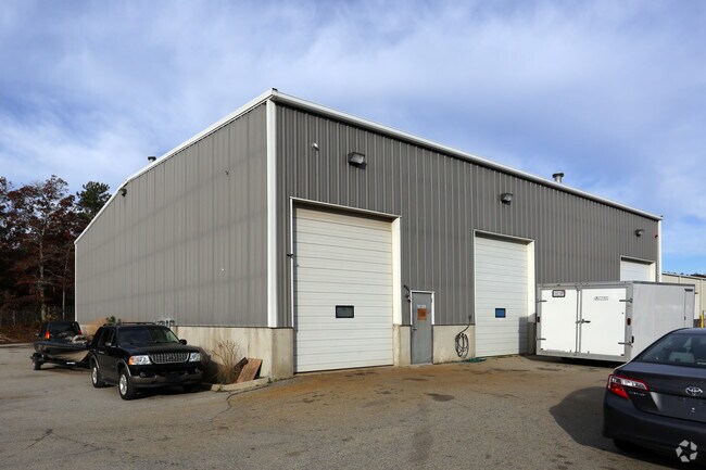
Property Detail
135 State Rd
BOUR-000030-000000-000012
Barnstable
Commercialbuilding
Massachusetts
B and X Area of moderate flood hazard, usually the area between the limits of the 100-year and 500-year floods.
1 AC
2025
Boston Southshore
2025
Other Market Areas
013800
Barnstable Town, MA
6,400 SF
NEARBY LISTINGS FOR SALE OR LEASE
DEMOGRAPHICS near 135 State Rd
1 mile
3 mile
5 mile
2025 Total Population
3,117
13,002
31,677
2030 Population
3,017
12,983
31,975
Pop Growth 2025-2030
(3.21%)
(0.15%)
+ 0.94%
Average Age
47
44
44
2025 Total Households
1,214
4,922
12,161
HH Growth 2025-2030
(3.46%)
(0.55%)
+ 0.60%
Median Household Inc
$115,937
$113,478
$113,794
Avg Household Size
2.40
2.60
2.50
2025 Avg HH Vehicles
2.00
2.00
2.00
Median Home Value
$633,064
$532,892
$566,203
Median Year Built
1984
1986
1982
Nearby Places
Map Layers
Map Styles
 Street
 Aerial
Layers
 Traffic
 Biking
Places
Listings with unknown addresses are not visible on the map
- Restaurants
- Banks
- Shops
- Fitness
- Groceries
PUBLIC TRANSPORTATION
COMMUTER RAIL
Bourne (CapeFLYER - Cape Cod Regional Transit Authority)
Drive
Walk
Distance
Bourne (CapeFLYER - Cape Cod Regional Transit Authority)
9 min
5.7 mi
Buzzards Bay (CapeFLYER - Cape Cod Regional Transit Authority)
Drive
Walk
Distance
Buzzards Bay (CapeFLYER - Cape Cod Regional Transit Authority)
11 min
6.2 mi
AIRPORT
Martha's Vineyard
Drive
Walk
Distance
Martha's Vineyard
98 min
36.9 mi
Freight Ports
Port of New Bedford Harbor
Drive
Walk
Distance
Port of New Bedford Harbor
43 min
31.7 mi
SALE & LEASE HISTORY
LISTING DATE
SALE/LEASE

Nov 02, 2016
For Sale
Nearby Properties
Address
Land Use
TOTAL SIZE
Lot Size
Zoning
Address
Land Use
TOTAL SIZE
Lot Size
Zoning
654.71 AC
R40
Address
Land Use
TOTAL SIZE
Lot Size
Zoning
Address
Land Use
TOTAL SIZE
Lot Size
Zoning
2,295.68 AC
R-1
Address
Land Use
TOTAL SIZE
Lot Size
Zoning
16.20 AC
BL-1
Address
Land Use
TOTAL SIZE
Lot Size
Zoning
325 AC
R-1
Address
Land Use
TOTAL SIZE
Lot Size
Zoning
59,320 SF
5.74 AC
GC
Address
Land Use
TOTAL SIZE
Lot Size
Zoning
208 SF
125.13 AC
SDD
Address
Land Use
TOTAL SIZE
Lot Size
Zoning
5,928 SF
12.90 AC
Address
Land Use
TOTAL SIZE
Lot Size
Zoning
148.70 AC
R40
Address
Land Use
TOTAL SIZE
Lot Size
Zoning
Address
Land Use
TOTAL SIZE
Lot Size
Zoning
485.97 AC
RR
Address
Land Use
TOTAL SIZE
Lot Size
Zoning
29.83 AC
IND
Address
Land Use
TOTAL SIZE
Lot Size
Zoning
41.40 AC
IND
Address
Land Use
TOTAL SIZE
Lot Size
Zoning
11.97 AC
MARINE
Address
Land Use
TOTAL SIZE
Lot Size
Zoning
31.50 AC
MARINE
Address
Land Use
TOTAL SIZE
Lot Size
Zoning
36,388 SF
6.70 AC
BL-1
Address
Land Use
TOTAL SIZE
Lot Size
Zoning
40,476 SF
7 AC
BL-1
Address
Land Use
TOTAL SIZE
Lot Size
Zoning
39,202 SF
6.31 AC
BL-1
Address
Land Use
TOTAL SIZE
Lot Size
Zoning
21.30 AC
IND
Address
Land Use
TOTAL SIZE
Lot Size
Zoning
4,146 SF
11.40 AC
BL-1
Address
Land Use
TOTAL SIZE
Lot Size
Zoning
8,989 SF
1.19 AC
MARINE
Address
Land Use
TOTAL SIZE
Lot Size
Zoning
Address
Land Use
TOTAL SIZE
Lot Size
Zoning
16,449 SF
4.21 AC
Address
Land Use
TOTAL SIZE
Lot Size
Zoning
10,682 SF
2.05 AC
GC
Address
Land Use
TOTAL SIZE
Lot Size
Zoning
15,740 SF
4.30 AC
R-1
Address
Land Use
TOTAL SIZE
Lot Size
Zoning
12,480 SF
1 AC
BL-1
Address
Land Use
TOTAL SIZE
Lot Size
Zoning
3,190 SF
0.64 AC
R-1
Address
Land Use
TOTAL SIZE
Lot Size
Zoning
14.92 AC
GC
Address
Land Use
TOTAL SIZE
Lot Size
Zoning
10,000 SF
13.15 AC
R40
Address
Land Use
TOTAL SIZE
Lot Size
Zoning
37,257 SF
3.54 AC
R40
The World's #1 Commercial Real Estate Marketplace
Connect with us
© 2026 CoStar Group
The information above has been obtained from sources believed reliable. While we do not doubt its accuracy we have not verified it and make no guarantee, warranty or representation about it. It is your responsibility to independently confirm its accuracy and completeness. Any projections, opinions, assumptions, or estimates used are for example only and do not represent the current or future performance of the property. The value of this transaction to you depends on tax and other factors which should be evaluated by your tax, financial, and legal advisors. You and your advisors should conduct a careful, independent investigation of the property to determine to your satisfaction the suitability of the property for your needs.