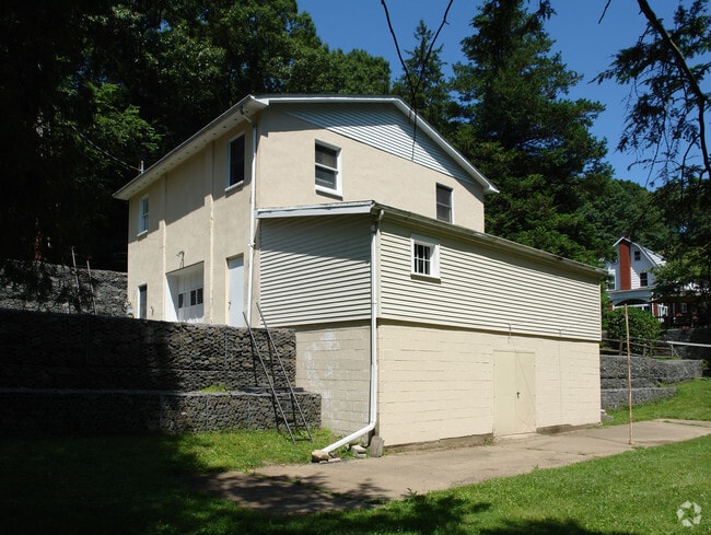
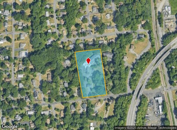
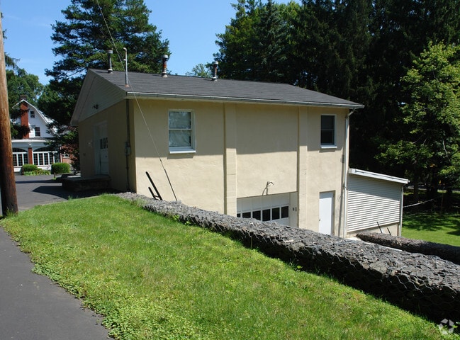
Property Record
135 W Crooked Hill Rd, Pearl River, NY 10965

NEARBY LISTINGS FOR SALE OR LEASE
Property Detail
135 W Crooked Hill Rd
392489-068-011-0002-041-001-0000
STAFF HOUSING-10 UNITS 40/10/14/17
Publichealthcarefacility
Rockland
X
New York
36087C0159G
41.1
2023
2.77 AC
2024
Rockland County
012600
Northern New Jersey
33,726 SF
New York-Jersey City-White Plains, NY-NJ
DEMOGRAPHICS near 135 W Crooked Hill Rd
1 Mile
3 Mile
5 Mile
2024 Total Population
9,665
76,736
237,156
2029 Population
9,608
76,653
236,253
Pop Growth 2024-2029
(0.59%)
(0.11%)
(0.38%)
Average Age
40
40
37
2024 Total Households
3,327
25,460
70,143
HH Growth 2024-2029
(0.66%)
(0.05%)
(0.34%)
Median Household Inc
$121,197
$122,701
$109,659
Avg Household Size
2.80
2.90
3.20
2024 Avg HH Vehicles
2.00
2.00
2.00
Median Home Value
$535,235
$639,469
$664,349
Median Year Built
1958
1966
1969
Nearby Places
- Restaurants
- Banks
- Shops
- Fitness
- Groceries
PUBLIC TRANSPORTATION
COMMUTER RAIL
Pearl River (Pascack Valley Line - NJ Transit Commuter Rail (NJ Transit))
DRIVE
WALK
Distance
Pearl River (Pascack Valley Line - NJ Transit Commuter Rail (NJ Transit))
4 min
18 min
0.9 mi
Nanuet (Pascack Valley Line - NJ Transit Commuter Rail (NJ Transit))
DRIVE
WALK
Distance
Nanuet (Pascack Valley Line - NJ Transit Commuter Rail (NJ Transit))
8 min
2.7 mi
AIRPORT
Westchester County
DRIVE
WALK
Distance
Westchester County
37 min
24.5 mi
LaGuardia
DRIVE
WALK
Distance
LaGuardia
49 min
29.2 mi
Newark Liberty International
DRIVE
WALK
Distance
Newark Liberty International
44 min
31.9 mi
Freight Ports
NY - Red Hook Container Terminal
DRIVE
WALK
Distance
NY - Red Hook Container Terminal
58 min
33.1 mi
Nearby Properties
Address
Land Use
TOTAL SIZE
Lot Size
Zoning
Address
Land Use
TOTAL SIZE
Lot Size
Zoning
402,385 SF
23.10 AC
LI
Address
Land Use
TOTAL SIZE
Lot Size
Zoning
63,621 SF
180.20 AC
LI
Address
Land Use
TOTAL SIZE
Lot Size
Zoning
Address
Land Use
TOTAL SIZE
Lot Size
Zoning
7.04 AC
SED
Address
Land Use
TOTAL SIZE
Lot Size
Zoning
Address
Land Use
TOTAL SIZE
Lot Size
Zoning
Address
Land Use
TOTAL SIZE
Lot Size
Zoning
22.75 AC
Address
Land Use
TOTAL SIZE
Lot Size
Zoning
11.48 AC
OR-3
Address
Land Use
TOTAL SIZE
Lot Size
Zoning
9.29 AC
SED
Address
Land Use
TOTAL SIZE
Lot Size
Zoning
17 AC
OR1
Address
Land Use
TOTAL SIZE
Lot Size
Zoning
36.49 AC
OR-2
Address
Land Use
TOTAL SIZE
Lot Size
Zoning
31.79 AC
OR2
Address
Land Use
TOTAL SIZE
Lot Size
Zoning
37,600 SF
31.41 AC
Address
Land Use
TOTAL SIZE
Lot Size
Zoning
71,166 SF
7.26 AC
B3
Address
Land Use
TOTAL SIZE
Lot Size
Zoning
24.45 AC
R40
Address
Land Use
TOTAL SIZE
Lot Size
Zoning
1,295,615 SF
93.54 AC
OP
Address
Land Use
TOTAL SIZE
Lot Size
Zoning
9.19 AC
OR2
Address
Land Use
TOTAL SIZE
Lot Size
Zoning
29.86 AC
ORL
Address
Land Use
TOTAL SIZE
Lot Size
Zoning
116,650 SF
39.20 AC
05
Address
Land Use
TOTAL SIZE
Lot Size
Zoning
8.02 AC
BUS2
Address
Land Use
TOTAL SIZE
Lot Size
Zoning
11.45 AC
A
Address
Land Use
TOTAL SIZE
Lot Size
Zoning
50,280 SF
24.37 AC
Address
Land Use
TOTAL SIZE
Lot Size
Zoning
14.56 AC
ORL
Address
Land Use
TOTAL SIZE
Lot Size
Zoning
132,614 SF
15.74 AC
OR3
Address
Land Use
TOTAL SIZE
Lot Size
Zoning
11.94 AC
ORL
Address
Land Use
TOTAL SIZE
Lot Size
Zoning
11.50 AC
OR1
Address
Land Use
TOTAL SIZE
Lot Size
Zoning
107,043 SF
11 AC
OR3
Address
Land Use
TOTAL SIZE
Lot Size
Zoning
152,854 SF
18.75 AC
RS
Address
Land Use
TOTAL SIZE
Lot Size
Zoning
42,501 SF
3.20 AC
B2
Address
Land Use
TOTAL SIZE
Lot Size
Zoning
The World's #1 Commercial Real Estate Marketplace
Connect with us
© 2025 CoStar Group
The information above has been obtained from sources believed reliable. While we do not doubt its accuracy we have not verified it and make no guarantee, warranty or representation about it. It is your responsibility to independently confirm its accuracy and completeness. Any projections, opinions, assumptions, or estimates used are for example only and do not represent the current or future performance of the property. The value of this transaction to you depends on tax and other factors which should be evaluated by your tax, financial, and legal advisors. You and your advisors should conduct a careful, independent investigation of the property to determine to your satisfaction the suitability of the property for your needs.