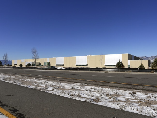
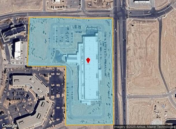
Property Record
1350 Bellprat Vw, Colorado Springs, CO 80921

NEARBY LISTINGS FOR SALE OR LEASE
Property Detail
1350 Bellprat Vw
Colorado Springs, CO
Bellprat Sub Fil No 1
62200-03-006
LOT 1 BELLPRAT SUB FIL NO 1
Industrialgeneral
El Paso
X
Colorado
08041C0506G
1
2024
17.75 AC
2025
Northeast
007205
Colorado Springs
154,816 SF
DEMOGRAPHICS near 1350 Bellprat Vw
1 Mile
3 Mile
5 Mile
2024 Total Population
2,479
34,746
122,867
2029 Population
2,675
36,804
129,024
Pop Growth 2024-2029
+ 7.91%
+ 5.92%
+ 5.01%
Average Age
38
39
38
2024 Total Households
967
12,798
44,401
HH Growth 2024-2029
+ 7.86%
+ 6.17%
+ 5.20%
Median Household Inc
$125,818
$123,564
$111,475
Avg Household Size
2.60
2.70
2.70
2024 Avg HH Vehicles
2.00
2.00
2.00
Median Home Value
$634,712
$579,331
$477,516
Median Year Built
2010
2006
1997
Nearby Places
Map Layers
Map Styles
 Street
 Aerial
- Restaurants
- Banks
- Shops
- Fitness
- Groceries
PUBLIC TRANSPORTATION
AIRPORT
City of Colorado Springs Municipal
DRIVE
WALK
Distance
City of Colorado Springs Municipal
28 min
17.4 mi
Freight Ports
Tulsa Port Of Catoosa
DRIVE
WALK
Distance
Tulsa Port Of Catoosa
736 min
692.4 mi
Nearby Properties
Address
Land Use
TOTAL SIZE
Lot Size
Zoning
Address
Land Use
TOTAL SIZE
Lot Size
Zoning
361,165 SF
59.11 AC
PDZ
Address
Land Use
TOTAL SIZE
Lot Size
Zoning
625 SF
7.15 AC
RR-5
Address
Land Use
TOTAL SIZE
Lot Size
Zoning
177,966 SF
57.81 AC
PDZ HR
Address
Land Use
TOTAL SIZE
Lot Size
Zoning
261,339 SF
10.42 AC
MX-M CU
Address
Land Use
TOTAL SIZE
Lot Size
Zoning
278,951 SF
32.43 AC
BP/CR HR
Address
Land Use
TOTAL SIZE
Lot Size
Zoning
257,140 SF
30.17 AC
MX-N/CR MX
Address
Land Use
TOTAL SIZE
Lot Size
Zoning
121,820 SF
14.73 AC
BP
Address
Land Use
TOTAL SIZE
Lot Size
Zoning
187,841 SF
40.33 AC
A
Address
Land Use
TOTAL SIZE
Lot Size
Zoning
95,337 SF
49.29 AC
BP
Address
Land Use
TOTAL SIZE
Lot Size
Zoning
103,166 SF
8.88 AC
BP
Address
Land Use
TOTAL SIZE
Lot Size
Zoning
562,942 SF
27.13 AC
PDZ
Address
Land Use
TOTAL SIZE
Lot Size
Zoning
56,290 SF
6.55 AC
A/CR
Address
Land Use
TOTAL SIZE
Lot Size
Zoning
114,474 SF
12.95 AC
BP
Address
Land Use
TOTAL SIZE
Lot Size
Zoning
480 SF
11 AC
A UV
Address
Land Use
TOTAL SIZE
Lot Size
Zoning
316,105 SF
19.73 AC
PDZ
Address
Land Use
TOTAL SIZE
Lot Size
Zoning
323,646 SF
31.30 AC
A BP/CR BP
Address
Land Use
TOTAL SIZE
Lot Size
Zoning
1,251,233 SF
17.63 AC
BP/CR HR
Address
Land Use
TOTAL SIZE
Lot Size
Zoning
58,774 SF
5 AC
BP
Address
Land Use
TOTAL SIZE
Lot Size
Zoning
391,914 SF
3.13 AC
PDZ
Address
Land Use
TOTAL SIZE
Lot Size
Zoning
35,862 SF
5.95 AC
MX-N
Address
Land Use
TOTAL SIZE
Lot Size
Zoning
211,974 SF
25.15 AC
BP CU
Address
Land Use
TOTAL SIZE
Lot Size
Zoning
48,673 SF
5.51 AC
R-5 P
Address
Land Use
TOTAL SIZE
Lot Size
Zoning
68,829 SF
6 AC
BP/CR
Address
Land Use
TOTAL SIZE
Lot Size
Zoning
50,471 SF
7.28 AC
BP
Address
Land Use
TOTAL SIZE
Lot Size
Zoning
188,626 SF
22.34 AC
BP/CR HR
Address
Land Use
TOTAL SIZE
Lot Size
Zoning
47,313 SF
11.15 AC
MX-N
Address
Land Use
TOTAL SIZE
Lot Size
Zoning
181,852 SF
20.99 AC
BP/CR HR
Address
Land Use
TOTAL SIZE
Lot Size
Zoning
151,287 SF
9.40 AC
PDZ HR
Address
Land Use
TOTAL SIZE
Lot Size
Zoning
25,194 SF
4 AC
R-5 P
Address
Land Use
TOTAL SIZE
Lot Size
Zoning
14,866 SF
12.71 AC
A
The World's #1 Commercial Real Estate Marketplace
Connect with us
© 2025 CoStar Group
The information above has been obtained from sources believed reliable. While we do not doubt its accuracy we have not verified it and make no guarantee, warranty or representation about it. It is your responsibility to independently confirm its accuracy and completeness. Any projections, opinions, assumptions, or estimates used are for example only and do not represent the current or future performance of the property. The value of this transaction to you depends on tax and other factors which should be evaluated by your tax, financial, and legal advisors. You and your advisors should conduct a careful, independent investigation of the property to determine to your satisfaction the suitability of the property for your needs.