Property Record
1350 E 8Th St, White Cloud, MI 49349

Property Detail
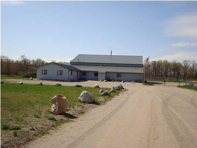
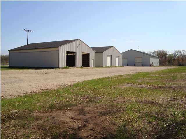
1350 E 8Th St
Autorepair
PART OF N 1/2 NE 1/4 COM ON N SEC LINE S 88D 21'46W 1313.01 FT FROM NE COR, TH S 01D 12'09W 1319.62 FT TO N 1/8 LINE,
LOCAL ZONE
Newaygo
B and X Area of moderate flood hazard, usually the area between the limits of the 100-year and 500-year floods.
Michigan
2025
20.50 AC
2025
Newaygo County
970700
West Michigan
12,072 SF
15-08-200-013
NEARBY LISTINGS FOR SALE OR LEASE
-
-
View all White Cloud listings for sale on LoopNet.com
DEMOGRAPHICS near 1350 E 8Th St
1 mile
3 mile
5 mile
2024 Total Population
864
2,859
5,511
2029 Population
888
2,941
5,691
Pop Growth 2024-2029
+ 2.78%
+ 2.87%
+ 3.27%
Average Age
40
41
42
2024 Total Households
281
980
2,039
HH Growth 2024-2029
+ 2.49%
+ 2.86%
+ 3.33%
Median Household Inc
$55,263
$55,624
$57,927
Avg Household Size
2.60
2.60
2.50
2024 Avg HH Vehicles
2.00
2.00
2.00
Median Home Value
$185,106
$177,664
$183,441
Median Year Built
1975
1976
1978
Nearby Places
Map Layers
Map Styles
 Street
 Aerial
Transit
 Traffic
 Biking
Places
Listings with unknown addresses are not visible on the map
- Restaurants
- Banks
- Shops
- Fitness
- Groceries
Nearby Properties
Address
Land Use
TOTAL SIZE
Lot Size
Zoning
Address
Land Use
TOTAL SIZE
Lot Size
Zoning
114,073 SF
30.75 AC
LOCAL ZONE
Address
Land Use
TOTAL SIZE
Lot Size
Zoning
Address
Land Use
TOTAL SIZE
Lot Size
Zoning
22,400 SF
2.15 AC
LOCAL ZONE
Address
Land Use
TOTAL SIZE
Lot Size
Zoning
19,212 SF
2.31 AC
LOCAL ZONE
Address
Land Use
TOTAL SIZE
Lot Size
Zoning
5,440 SF
1.12 AC
LOCAL ZONE
Address
Land Use
TOTAL SIZE
Lot Size
Zoning
27,788 SF
1.51 AC
LOCAL ZONE
Address
Land Use
TOTAL SIZE
Lot Size
Zoning
29,832 SF
3 AC
LOCAL ZONE
Address
Land Use
TOTAL SIZE
Lot Size
Zoning
19,264 SF
2.05 AC
LOCAL ZONE
Address
Land Use
TOTAL SIZE
Lot Size
Zoning
16,260 SF
6.71 AC
LOCAL ZONE
Address
Land Use
TOTAL SIZE
Lot Size
Zoning
11,412 SF
2.55 AC
LOCAL ZONE
Address
Land Use
TOTAL SIZE
Lot Size
Zoning
19,610 SF
0.88 AC
LOCAL ZONE
Address
Land Use
TOTAL SIZE
Lot Size
Zoning
3,326 SF
0.56 AC
LOCAL ZONE
Address
Land Use
TOTAL SIZE
Lot Size
Zoning
22,040 SF
6.90 AC
LOCAL ZONE
Address
Land Use
TOTAL SIZE
Lot Size
Zoning
9,020 SF
1.02 AC
LOCAL ZONE
Address
Land Use
TOTAL SIZE
Lot Size
Zoning
15,072 SF
3.35 AC
LOCAL ZONE
Address
Land Use
TOTAL SIZE
Lot Size
Zoning
89,741 SF
6.12 AC
LOCAL ZONE
Address
Land Use
TOTAL SIZE
Lot Size
Zoning
7,734 SF
0.48 AC
LOCAL ZONE
Address
Land Use
TOTAL SIZE
Lot Size
Zoning
7,800 SF
2.61 AC
LOCAL ZONE
Address
Land Use
TOTAL SIZE
Lot Size
Zoning
16,584 SF
2.49 AC
LOCAL ZONE
Address
Land Use
TOTAL SIZE
Lot Size
Zoning
4.21 AC
LOCAL ZONE
Address
Land Use
TOTAL SIZE
Lot Size
Zoning
5,040 SF
3.29 AC
LOCAL ZONE
Address
Land Use
TOTAL SIZE
Lot Size
Zoning
1.31 AC
LOCAL ZONE
Address
Land Use
TOTAL SIZE
Lot Size
Zoning
3,076 SF
2.30 AC
LOCAL ZONE
Address
Land Use
TOTAL SIZE
Lot Size
Zoning
5,332 SF
0.35 AC
LOCAL ZONE
Address
Land Use
TOTAL SIZE
Lot Size
Zoning
5,187 SF
0.54 AC
LOCAL ZONE
Address
Land Use
TOTAL SIZE
Lot Size
Zoning
74.65 AC
LOCAL ZONE
Address
Land Use
TOTAL SIZE
Lot Size
Zoning
6,360 SF
0.68 AC
LOCAL ZONE
Address
Land Use
TOTAL SIZE
Lot Size
Zoning
5,558 SF
0.60 AC
LOCAL ZONE
Address
Land Use
TOTAL SIZE
Lot Size
Zoning
4.03 AC
LOCAL ZONE
Address
Land Use
TOTAL SIZE
Lot Size
Zoning
40.12 AC
LOCAL ZONE
The World's #1 Commercial Real Estate Marketplace
Connect with us
© 2026 CoStar Group
The information above has been obtained from sources believed reliable. While we do not doubt its accuracy we have not verified it and make no guarantee, warranty or representation about it. It is your responsibility to independently confirm its accuracy and completeness. Any projections, opinions, assumptions, or estimates used are for example only and do not represent the current or future performance of the property. The value of this transaction to you depends on tax and other factors which should be evaluated by your tax, financial, and legal advisors. You and your advisors should conduct a careful, independent investigation of the property to determine to your satisfaction the suitability of the property for your needs.