Property Record
1350 E Draper Pky, Draper, UT 84020
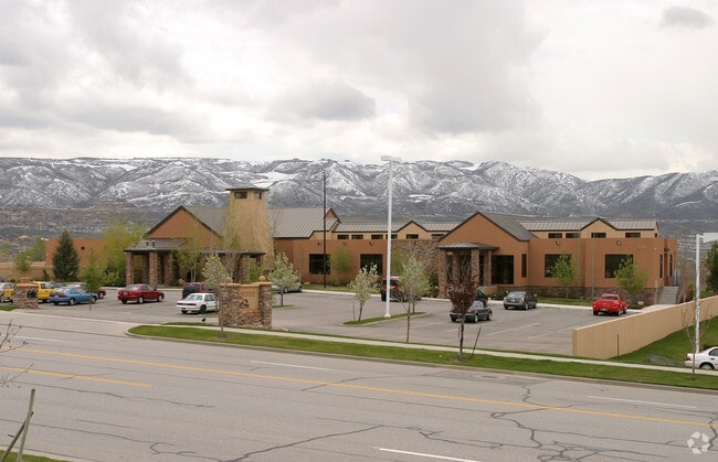

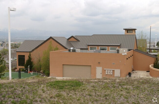
Property Detail
1350 E Draper Pky
28-29-429-010-0000
BEG S 02956 W 802.58 FT ALG SEC LINE FR E 1/4 COR SEC 29,T3S, R1E, SLM; S 02956 W 546.40 FT TO N LINE OF CANAL; N 241219 W 44.76 FT; NWLY ALG 146.50 FT RADIUS CURVE TO L 160.90 FT (CHD N 554825 W 152.93 FT) TO N LINE OF 1300 E ST; NWLY ALG 1050.26 FT
Officebuilding
Salt Lake
CC
Utah
B and X Area of moderate flood hazard, usually the area between the limits of the 100-year and 500-year floods.
2.99 AC
2024
Draper
2025
Salt Lake City
112815
Salt Lake City-Murray, UT
11,543 SF
NEARBY LISTINGS FOR SALE OR LEASE
DEMOGRAPHICS near 1350 E Draper Pky
1 mile
3 mile
5 mile
2025 Total Population
10,698
78,493
178,251
2030 Population
10,992
80,595
182,855
Pop Growth 2025-2030
+ 2.75%
+ 2.68%
+ 2.58%
Average Age
39
39
38
2025 Total Households
3,120
23,722
57,503
HH Growth 2025-2030
+ 2.85%
+ 2.96%
+ 2.76%
Median Household Inc
$152,520
$130,465
$119,896
Avg Household Size
3.40
3.10
3.00
2025 Avg HH Vehicles
3.00
2.00
2.00
Median Home Value
$830,176
$774,346
$720,386
Median Year Built
1992
1995
1995
Nearby Places
Map Layers
Map Styles
 Street
 Aerial
Transit
 Traffic
 Biking
Places
Listings with unknown addresses are not visible on the map
- Restaurants
- Banks
- Shops
- Fitness
- Groceries
PUBLIC TRANSPORTATION
TRANSIT/SUBWAY
Draper Town Center Station (Blue Line - Utah Transit Authority (UTA))
Drive
Walk
Distance
Draper Town Center Station (Blue Line - Utah Transit Authority (UTA))
2 min
12 min
0.6 mi
COMMUTER RAIL
Draper Station (FrontRunner - Utah Transit Authority (UTA))
Drive
Walk
Distance
Draper Station (FrontRunner - Utah Transit Authority (UTA))
9 min
3.8 mi
South Jordan Station (FrontRunner - Utah Transit Authority (UTA))
Drive
Walk
Distance
South Jordan Station (FrontRunner - Utah Transit Authority (UTA))
8 min
4.9 mi
AIRPORT
Salt Lake City International
Drive
Walk
Distance
Salt Lake City International
30 min
23.7 mi
Provo Municipal
Drive
Walk
Distance
Provo Municipal
43 min
31.0 mi
Freight Ports
Port of Stockton
Drive
Walk
Distance
Port of Stockton
730 min
714.1 mi
Nearby Properties
Address
Land Use
TOTAL SIZE
Lot Size
Zoning
Address
Land Use
TOTAL SIZE
Lot Size
Zoning
40,495 SF
33.28 AC
RM-1
Address
Land Use
TOTAL SIZE
Lot Size
Zoning
774,515 SF
87.50 AC
M-1
Address
Land Use
TOTAL SIZE
Lot Size
Zoning
1,055,572 SF
8.31 AC
CR
Address
Land Use
TOTAL SIZE
Lot Size
Zoning
210,421 SF
6.87 AC
CR
Address
Land Use
TOTAL SIZE
Lot Size
Zoning
398,320 SF
40 AC
1110
Address
Land Use
TOTAL SIZE
Lot Size
Zoning
392,144 SF
30.63 AC
1113
Address
Land Use
TOTAL SIZE
Lot Size
Zoning
186,651 SF
35.87 AC
C-R
Address
Land Use
TOTAL SIZE
Lot Size
Zoning
277,938 SF
13.90 AC
CSD-DD
Address
Land Use
TOTAL SIZE
Lot Size
Zoning
197,645 SF
19.51 AC
1122
Address
Land Use
TOTAL SIZE
Lot Size
Zoning
126,531 SF
11.50 AC
1244
Address
Land Use
TOTAL SIZE
Lot Size
Zoning
311,202 SF
0.01 AC
4180
Address
Land Use
TOTAL SIZE
Lot Size
Zoning
391,078 SF
5.78 AC
IC
Address
Land Use
TOTAL SIZE
Lot Size
Zoning
101,790 SF
5.69 AC
PUD(16
Address
Land Use
TOTAL SIZE
Lot Size
Zoning
115,637 SF
36.38 AC
TSD
Address
Land Use
TOTAL SIZE
Lot Size
Zoning
374,097 SF
6.87 AC
CSDDPM
Address
Land Use
TOTAL SIZE
Lot Size
Zoning
130,809 SF
16.13 AC
RM 1
Address
Land Use
TOTAL SIZE
Lot Size
Zoning
265,332 SF
8.94 AC
C-C
Address
Land Use
TOTAL SIZE
Lot Size
Zoning
279,829 SF
18.28 AC
CSD-LP
Address
Land Use
TOTAL SIZE
Lot Size
Zoning
353,500 SF
29.38 AC
CR
Address
Land Use
TOTAL SIZE
Lot Size
Zoning
317.68 AC
1115
Address
Land Use
TOTAL SIZE
Lot Size
Zoning
255,090 SF
17.91 AC
CSDDRC
Address
Land Use
TOTAL SIZE
Lot Size
Zoning
146,280 SF
0.01 AC
CBD
Address
Land Use
TOTAL SIZE
Lot Size
Zoning
77,905 SF
7.15 AC
CO2
Address
Land Use
TOTAL SIZE
Lot Size
Zoning
319,222 SF
6.12 AC
CSD-DD
Address
Land Use
TOTAL SIZE
Lot Size
Zoning
179,860 SF
11.50 AC
M-1
Address
Land Use
TOTAL SIZE
Lot Size
Zoning
198.67 AC
4280
Address
Land Use
TOTAL SIZE
Lot Size
Zoning
255,928 SF
14.90 AC
M-1
Address
Land Use
TOTAL SIZE
Lot Size
Zoning
144,648 SF
20.53 AC
1110
Address
Land Use
TOTAL SIZE
Lot Size
Zoning
197,352 SF
28.67 AC
2000
Address
Land Use
TOTAL SIZE
Lot Size
Zoning
176,107 SF
19.30 AC
1108
The World's #1 Commercial Real Estate Marketplace
Connect with us
© 2026 CoStar Group
The information above has been obtained from sources believed reliable. While we do not doubt its accuracy we have not verified it and make no guarantee, warranty or representation about it. It is your responsibility to independently confirm its accuracy and completeness. Any projections, opinions, assumptions, or estimates used are for example only and do not represent the current or future performance of the property. The value of this transaction to you depends on tax and other factors which should be evaluated by your tax, financial, and legal advisors. You and your advisors should conduct a careful, independent investigation of the property to determine to your satisfaction the suitability of the property for your needs.