Property Record
1350 Ellis St, Waukesha, WI 53186
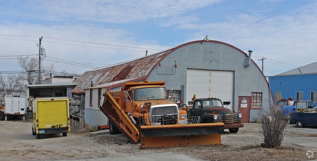
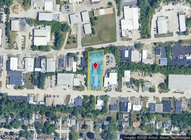
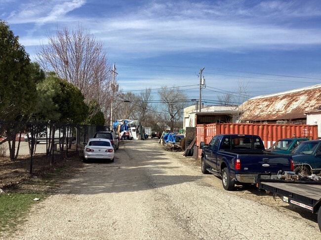
This Property Is For Sale
NEARBY LISTINGS FOR SALE OR LEASE
Property Detail
1350 Ellis St
Milwaukee-Waukesha-West Allis, WI
Lawndale
WAKC-1304-998-001
PT SE1/4 SEC 2 T6N R19E COM INTSC CTR LI ELLIS ST & E LI LAWNDALE; S88 23E 286.87 TO BEG; S88 23E 135; N2 9 13 E 433.75; S81 3846 W 137.3; S2 913 W 410.01 TO BEG EXC N 30 & S30 1.12 AC R2475/388
Commercialnec
Waukesha
X
Wisconsin
55133C0214H
54
2024
1.12 AC
2024
Central Waukesha
202500
Milwaukee/Madison
14,702 SF
DEMOGRAPHICS near 1350 Ellis St
1 Mile
3 Mile
5 Mile
2024 Total Population
10,086
61,279
120,118
2029 Population
10,426
63,658
124,512
Pop Growth 2024-2029
+ 3.37%
+ 3.88%
+ 3.66%
Average Age
39
40
41
2024 Total Households
4,269
26,840
50,715
HH Growth 2024-2029
+ 3.61%
+ 4.03%
+ 3.75%
Median Household Inc
$77,715
$67,165
$81,348
Avg Household Size
2.20
2.20
2.30
2024 Avg HH Vehicles
2.00
2.00
2.00
Median Home Value
$243,552
$246,118
$291,276
Median Year Built
1958
1975
1981
Nearby Places
Map Layers
Map Styles
 Street
 Aerial
- Restaurants
- Banks
- Shops
- Fitness
- Groceries
PUBLIC TRANSPORTATION
AIRPORT
General Mitchell International
DRIVE
WALK
Distance
General Mitchell International
36 min
21.4 mi
Freight Ports
Port Milwaukee
DRIVE
WALK
Distance
Port Milwaukee
31 min
19.1 mi
Nearby Properties
Address
Land Use
TOTAL SIZE
Lot Size
Zoning
Address
Land Use
TOTAL SIZE
Lot Size
Zoning
19.44 AC
Address
Land Use
TOTAL SIZE
Lot Size
Zoning
19.44 AC
Address
Land Use
TOTAL SIZE
Lot Size
Zoning
25.92 AC
Address
Land Use
TOTAL SIZE
Lot Size
Zoning
201,304 SF
29.43 AC
RM-2(PUD)
Address
Land Use
TOTAL SIZE
Lot Size
Zoning
56.81 AC
Address
Land Use
TOTAL SIZE
Lot Size
Zoning
21.73 AC
M-1
Address
Land Use
TOTAL SIZE
Lot Size
Zoning
68,591 SF
2.97 AC
RM-3(PUD)
Address
Land Use
TOTAL SIZE
Lot Size
Zoning
19.44 AC
Address
Land Use
TOTAL SIZE
Lot Size
Zoning
6.56 AC
I-1
Address
Land Use
TOTAL SIZE
Lot Size
Zoning
237,267 SF
16.14 AC
B-5
Address
Land Use
TOTAL SIZE
Lot Size
Zoning
167,693 SF
13.83 AC
B-5
Address
Land Use
TOTAL SIZE
Lot Size
Zoning
19 AC
RM-2
Address
Land Use
TOTAL SIZE
Lot Size
Zoning
Address
Land Use
TOTAL SIZE
Lot Size
Zoning
91,322 SF
8.48 AC
B-4
Address
Land Use
TOTAL SIZE
Lot Size
Zoning
140,144 SF
13.85 AC
RM-2(PUD)
Address
Land Use
TOTAL SIZE
Lot Size
Zoning
110,992 SF
12.15 AC
RM-1(PUD)
Address
Land Use
TOTAL SIZE
Lot Size
Zoning
10.57 AC
Address
Land Use
TOTAL SIZE
Lot Size
Zoning
187,050 SF
24.37 AC
B-5, C-1
Address
Land Use
TOTAL SIZE
Lot Size
Zoning
61,299 SF
6.59 AC
RM-2(PUD)
Address
Land Use
TOTAL SIZE
Lot Size
Zoning
28,942 SF
2.31 AC
B-3(22.52)
Address
Land Use
TOTAL SIZE
Lot Size
Zoning
79,529 SF
23.85 AC
I-1
Address
Land Use
TOTAL SIZE
Lot Size
Zoning
29.41 AC
B-5(PUD)
Address
Land Use
TOTAL SIZE
Lot Size
Zoning
24,981 SF
1.79 AC
B-3(22.52)
Address
Land Use
TOTAL SIZE
Lot Size
Zoning
11.54 AC
M-1
Address
Land Use
TOTAL SIZE
Lot Size
Zoning
110,948 SF
7.84 AC
RM-2(PUD)
Address
Land Use
TOTAL SIZE
Lot Size
Zoning
102,333 SF
11.99 AC
B-5(PUD)
Address
Land Use
TOTAL SIZE
Lot Size
Zoning
11.11 AC
B-5
Address
Land Use
TOTAL SIZE
Lot Size
Zoning
0.81 AC
B-2
Address
Land Use
TOTAL SIZE
Lot Size
Zoning
47,353 SF
5.41 AC
RM-2(PUD)
Address
Land Use
TOTAL SIZE
Lot Size
Zoning
111,624 SF
12.91 AC
RM-3(PUD)
The World's #1 Commercial Real Estate Marketplace
Connect with us
© 2025 CoStar Group
The information above has been obtained from sources believed reliable. While we do not doubt its accuracy we have not verified it and make no guarantee, warranty or representation about it. It is your responsibility to independently confirm its accuracy and completeness. Any projections, opinions, assumptions, or estimates used are for example only and do not represent the current or future performance of the property. The value of this transaction to you depends on tax and other factors which should be evaluated by your tax, financial, and legal advisors. You and your advisors should conduct a careful, independent investigation of the property to determine to your satisfaction the suitability of the property for your needs.