Property Record
1350 N Howard St, Akron, OH 44310
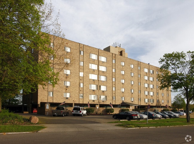


Property Detail
1350 N Howard St
Akron, OH
TR 2 W OF N HOWARD ST 2.440A
67-24295
Summit
Apartment
Ohio
2023
143
2025
2.35 AC
507501
Merriman Valley
31,500 SF
Cleveland
NEARBY LISTINGS FOR SALE OR LEASE
DEMOGRAPHICS near 1350 N Howard St
1 mile
3 mile
5 mile
2025 Total Population
12,003
97,198
212,461
2030 Population
11,884
96,905
212,997
Pop Growth 2025-2030
(0.99%)
(0.30%)
+ 0.25%
Average Age
39
40
40
2025 Total Households
4,803
43,359
93,151
HH Growth 2025-2030
(1.06%)
(0.30%)
+ 0.22%
Median Household Inc
$57,287
$57,505
$56,112
Avg Household Size
2.40
2.10
2.20
2025 Avg HH Vehicles
2.00
2.00
2.00
Median Home Value
$140,190
$164,708
$169,330
Median Year Built
1947
1955
1957
Nearby Places
Map Layers
Map Styles
 Street
 Aerial
Transit
 Traffic
 Biking
Places
Listings with unknown addresses are not visible on the map
- Restaurants
- Banks
- Shops
- Fitness
- Groceries
PUBLIC TRANSPORTATION
COMMUTER RAIL
Akron Northside (National Park Scenic Railway - Cuyahoga Valley Scenic Railroad)
Drive
Walk
Distance
Akron Northside (National Park Scenic Railway - Cuyahoga Valley Scenic Railroad)
5 min
2.3 mi
Big Bend (National Park Scenic Railway - Cuyahoga Valley Scenic Railroad)
Drive
Walk
Distance
Big Bend (National Park Scenic Railway - Cuyahoga Valley Scenic Railroad)
11 min
4.5 mi
AIRPORT
Akron-Canton Regional
Drive
Walk
Distance
Akron-Canton Regional
24 min
16.9 mi
Cleveland-Hopkins International
Drive
Walk
Distance
Cleveland-Hopkins International
57 min
39.8 mi
Freight Ports
Port of Toledo
Drive
Walk
Distance
Port of Toledo
160 min
134.3 mi
Nearby Properties
Address
Land Use
TOTAL SIZE
Lot Size
Zoning
Address
Land Use
TOTAL SIZE
Lot Size
Zoning
1,811,279 SF
38.71 AC
Address
Land Use
TOTAL SIZE
Lot Size
Zoning
1,004,220 SF
3.84 AC
Address
Land Use
TOTAL SIZE
Lot Size
Zoning
Address
Land Use
TOTAL SIZE
Lot Size
Zoning
348,519 SF
7.45 AC
Address
Land Use
TOTAL SIZE
Lot Size
Zoning
282,490 SF
20.76 AC
Address
Land Use
TOTAL SIZE
Lot Size
Zoning
91,104 SF
17.30 AC
Address
Land Use
TOTAL SIZE
Lot Size
Zoning
479,446 SF
6.07 AC
Address
Land Use
TOTAL SIZE
Lot Size
Zoning
314,622 SF
15.59 AC
Address
Land Use
TOTAL SIZE
Lot Size
Zoning
3.15 AC
Address
Land Use
TOTAL SIZE
Lot Size
Zoning
186,867 SF
1.48 AC
Address
Land Use
TOTAL SIZE
Lot Size
Zoning
229,392 SF
12.31 AC
Address
Land Use
TOTAL SIZE
Lot Size
Zoning
0.41 AC
Address
Land Use
TOTAL SIZE
Lot Size
Zoning
51,702 SF
0.36 AC
Address
Land Use
TOTAL SIZE
Lot Size
Zoning
66,302 SF
10.87 AC
Address
Land Use
TOTAL SIZE
Lot Size
Zoning
52,803 SF
1.33 AC
Address
Land Use
TOTAL SIZE
Lot Size
Zoning
311,197 SF
10.78 AC
Address
Land Use
TOTAL SIZE
Lot Size
Zoning
275,025 SF
0.98 AC
Address
Land Use
TOTAL SIZE
Lot Size
Zoning
118,928 SF
1.15 AC
Address
Land Use
TOTAL SIZE
Lot Size
Zoning
72,382 SF
4.70 AC
Address
Land Use
TOTAL SIZE
Lot Size
Zoning
232,791 SF
8.16 AC
Address
Land Use
TOTAL SIZE
Lot Size
Zoning
210,474 SF
1.87 AC
Address
Land Use
TOTAL SIZE
Lot Size
Zoning
10.78 AC
Address
Land Use
TOTAL SIZE
Lot Size
Zoning
215,975 SF
5.76 AC
Address
Land Use
TOTAL SIZE
Lot Size
Zoning
169,260 SF
9.95 AC
Address
Land Use
TOTAL SIZE
Lot Size
Zoning
82,418 SF
1.52 AC
Address
Land Use
TOTAL SIZE
Lot Size
Zoning
115,567 SF
9.06 AC
Address
Land Use
TOTAL SIZE
Lot Size
Zoning
123,088 SF
1.30 AC
Address
Land Use
TOTAL SIZE
Lot Size
Zoning
313,167 SF
18.50 AC
Address
Land Use
TOTAL SIZE
Lot Size
Zoning
Address
Land Use
TOTAL SIZE
Lot Size
Zoning
131,788 SF
13.99 AC
The World's #1 Commercial Real Estate Marketplace
Connect with us
© 2026 CoStar Group
The information above has been obtained from sources believed reliable. While we do not doubt its accuracy we have not verified it and make no guarantee, warranty or representation about it. It is your responsibility to independently confirm its accuracy and completeness. Any projections, opinions, assumptions, or estimates used are for example only and do not represent the current or future performance of the property. The value of this transaction to you depends on tax and other factors which should be evaluated by your tax, financial, and legal advisors. You and your advisors should conduct a careful, independent investigation of the property to determine to your satisfaction the suitability of the property for your needs.