Property Record
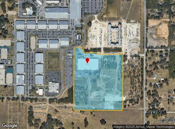
1350 Nw 80Th Ave, Ocala, FL 34482
NEARBY LISTINGS FOR SALE OR LEASE
Property Detail
1350 Nw 80Th Ave
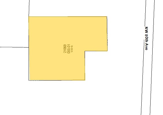
21068-000-01
SEC 12 TWP 15 RGE 20 COM SE COR TH N 00-02-11 E 1322.85 FT TH N 88-12-38 W 986.25 FT TH N 00-11-04 E 417.79 FT TO POB TH S 89-45-35 W 381.66 FT TH N 250.34 FT TH S 89-36-54 W 330 FT TH N 00-01-12 W 636 FT TH N 89-59-29 E 714.71 FT TH S 00-11-04 W 882
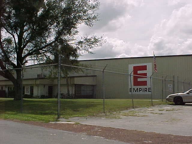
Warehouse
Marion
AE
Florida
12083C0484E
12.63 AC
2024
Outlying Marion County
2024
Ocala
002602
Ocala, FL
139,986 SF
DEMOGRAPHICS near 1350 Nw 80Th Ave
1 Mile
3 Mile
5 Mile
2024 Total Population
1,011
8,481
30,470
2029 Population
1,148
9,628
34,483
Pop Growth 2024-2029
+ 13.55%
+ 13.52%
+ 13.17%
Average Age
44
46
44
2024 Total Households
394
3,422
11,849
HH Growth 2024-2029
+ 13.45%
+ 13.38%
+ 13.30%
Median Household Inc
$68,537
$61,315
$58,242
Avg Household Size
2.50
2.30
2.30
2024 Avg HH Vehicles
2.00
2.00
2.00
Median Home Value
$270,833
$239,046
$217,090
Median Year Built
1998
1995
1995
Nearby Places
Map Layers
Map Styles
 Street
 Aerial
- Restaurants
- Banks
- Shops
- Fitness
- Groceries
Nearby Properties
Address
Land Use
TOTAL SIZE
Lot Size
Zoning
Address
Land Use
TOTAL SIZE
Lot Size
Zoning
794,310 SF
270.60 AC
A1
Address
Land Use
TOTAL SIZE
Lot Size
Zoning
152,355 SF
973.50 AC
GU
Address
Land Use
TOTAL SIZE
Lot Size
Zoning
440,924 SF
166.52 AC
PUD
Address
Land Use
TOTAL SIZE
Lot Size
Zoning
91,872 SF
216.43 AC
M1
Address
Land Use
TOTAL SIZE
Lot Size
Zoning
47,083 SF
4,305.80 AC
A1
Address
Land Use
TOTAL SIZE
Lot Size
Zoning
14,122 SF
73.47 AC
A1
Address
Land Use
TOTAL SIZE
Lot Size
Zoning
26,024 SF
226.67 AC
PUD
Address
Land Use
TOTAL SIZE
Lot Size
Zoning
89,136 SF
7.66 AC
M1
Address
Land Use
TOTAL SIZE
Lot Size
Zoning
15,000 SF
345.42 AC
PUD
Address
Land Use
TOTAL SIZE
Lot Size
Zoning
100,367 SF
6.40 AC
M1
Address
Land Use
TOTAL SIZE
Lot Size
Zoning
99,875 SF
6.12 AC
M1
Address
Land Use
TOTAL SIZE
Lot Size
Zoning
2,991 SF
17.37 AC
GU
Address
Land Use
TOTAL SIZE
Lot Size
Zoning
44,975 SF
5.39 AC
M1
Address
Land Use
TOTAL SIZE
Lot Size
Zoning
64,211 SF
4.64 AC
B5
Address
Land Use
TOTAL SIZE
Lot Size
Zoning
35,762 SF
4.50 AC
B2
Address
Land Use
TOTAL SIZE
Lot Size
Zoning
87,539 SF
7.26 AC
M1
Address
Land Use
TOTAL SIZE
Lot Size
Zoning
56,481 SF
4.73 AC
M1
Address
Land Use
TOTAL SIZE
Lot Size
Zoning
129,404 SF
12.63 AC
M1
Address
Land Use
TOTAL SIZE
Lot Size
Zoning
72,485 SF
23.01 AC
GU
Address
Land Use
TOTAL SIZE
Lot Size
Zoning
13,531 SF
6.38 AC
PUD
Address
Land Use
TOTAL SIZE
Lot Size
Zoning
11,325 SF
10 AC
A3
Address
Land Use
TOTAL SIZE
Lot Size
Zoning
40,820 SF
5.41 AC
M2
Address
Land Use
TOTAL SIZE
Lot Size
Zoning
8,323 SF
12.86 AC
A1
Address
Land Use
TOTAL SIZE
Lot Size
Zoning
39,000 SF
3.78 AC
RAC
Address
Land Use
TOTAL SIZE
Lot Size
Zoning
8,499 SF
119.87 AC
A1
Address
Land Use
TOTAL SIZE
Lot Size
Zoning
30,391 SF
2.76 AC
M1
Address
Land Use
TOTAL SIZE
Lot Size
Zoning
38,710 SF
2.56 AC
M1
Address
Land Use
TOTAL SIZE
Lot Size
Zoning
10,757 SF
71.10 AC
PUD
Address
Land Use
TOTAL SIZE
Lot Size
Zoning
16,644 SF
4.89 AC
B5
Address
Land Use
TOTAL SIZE
Lot Size
Zoning
762 SF
132.11 AC
GU
The World's #1 Commercial Real Estate Marketplace
Connect with us
© 2025 CoStar Group
The information above has been obtained from sources believed reliable. While we do not doubt its accuracy we have not verified it and make no guarantee, warranty or representation about it. It is your responsibility to independently confirm its accuracy and completeness. Any projections, opinions, assumptions, or estimates used are for example only and do not represent the current or future performance of the property. The value of this transaction to you depends on tax and other factors which should be evaluated by your tax, financial, and legal advisors. You and your advisors should conduct a careful, independent investigation of the property to determine to your satisfaction the suitability of the property for your needs.