Property Record
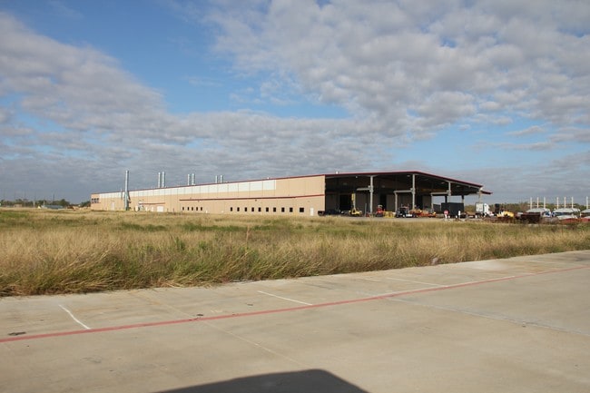
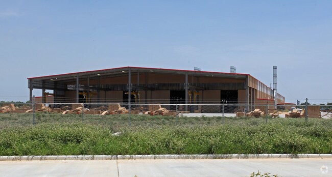
1350 Schlipf Rd, Katy, TX 77493

Property Detail
1350 Schlipf Rd
257677
S665801 PEDERSON ROAD BUS PARK REPLAT ACRES 25.4956 REST RES A (COMMERCIAL USE)
Industrialgeneral
WALLER
B and X Area of moderate flood hazard, usually the area between the limits of the 100-year and 500-year floods.
Texas
2024
25.50 AC
2025
Northwest Outliers
680100
Houston
182,600 SF
Houston-Pasadena-The Woodlands, TX
NEARBY LISTINGS FOR SALE OR LEASE
DEMOGRAPHICS near 1350 Schlipf Rd
1 mile
3 mile
5 mile
2025 Total Population
189
35,248
130,127
2030 Population
213
40,333
147,893
Pop Growth 2025-2030
+ 12.70%
+ 14.43%
+ 13.65%
Average Age
35
36
36
2025 Total Households
57
10,869
40,681
HH Growth 2025-2030
+ 12.28%
+ 14.82%
+ 13.94%
Median Household Inc
$133,928
$147,299
$134,041
Avg Household Size
3.30
3.20
3.20
2025 Avg HH Vehicles
2.00
2.00
2.00
Median Home Value
$391,666
$474,186
$472,576
Median Year Built
2011
2011
2011
Nearby Places
Map Layers
Map Styles
 Street
 Aerial
Layers
 Traffic
 Biking
Places
Listings with unknown addresses are not visible on the map
- Restaurants
- Banks
- Shops
- Fitness
- Groceries
SALE & LEASE HISTORY
LISTING DATE
SALE/LEASE

Dec 30, 2016
For Lease
Nearby Properties
Address
Land Use
TOTAL SIZE
Lot Size
Zoning
Address
Land Use
TOTAL SIZE
Lot Size
Zoning
720,217 SF
65.17 AC
Address
Land Use
TOTAL SIZE
Lot Size
Zoning
1,300,000 SF
60.33 AC
Address
Land Use
TOTAL SIZE
Lot Size
Zoning
1,566,415 SF
88.80 AC
Address
Land Use
TOTAL SIZE
Lot Size
Zoning
1,022,213 SF
86.50 AC
Address
Land Use
TOTAL SIZE
Lot Size
Zoning
16.46 AC
Address
Land Use
TOTAL SIZE
Lot Size
Zoning
866,200 SF
39.63 AC
Address
Land Use
TOTAL SIZE
Lot Size
Zoning
910,296 SF
50.41 AC
Address
Land Use
TOTAL SIZE
Lot Size
Zoning
678,028 SF
42.63 AC
Address
Land Use
TOTAL SIZE
Lot Size
Zoning
519,308 SF
150 AC
Address
Land Use
TOTAL SIZE
Lot Size
Zoning
Address
Land Use
TOTAL SIZE
Lot Size
Zoning
148,600 SF
14.61 AC
Address
Land Use
TOTAL SIZE
Lot Size
Zoning
1,226,088 SF
107.26 AC
Address
Land Use
TOTAL SIZE
Lot Size
Zoning
20.05 AC
SYQ
Address
Land Use
TOTAL SIZE
Lot Size
Zoning
505,690 SF
26.46 AC
Address
Land Use
TOTAL SIZE
Lot Size
Zoning
108,600 SF
9.08 AC
Address
Land Use
TOTAL SIZE
Lot Size
Zoning
510,614 SF
56.19 AC
Address
Land Use
TOTAL SIZE
Lot Size
Zoning
411,920 SF
22.31 AC
Address
Land Use
TOTAL SIZE
Lot Size
Zoning
168,025 SF
13.55 AC
Address
Land Use
TOTAL SIZE
Lot Size
Zoning
510,020 SF
7.29 AC
Address
Land Use
TOTAL SIZE
Lot Size
Zoning
419,840 SF
31.94 AC
Address
Land Use
TOTAL SIZE
Lot Size
Zoning
15.54 AC
Address
Land Use
TOTAL SIZE
Lot Size
Zoning
123,086 SF
13.49 AC
Address
Land Use
TOTAL SIZE
Lot Size
Zoning
342,360 SF
22.75 AC
Address
Land Use
TOTAL SIZE
Lot Size
Zoning
326,364 SF
17.39 AC
Address
Land Use
TOTAL SIZE
Lot Size
Zoning
237,584 SF
27.48 AC
Address
Land Use
TOTAL SIZE
Lot Size
Zoning
272,982 SF
17.26 AC
Address
Land Use
TOTAL SIZE
Lot Size
Zoning
123,917 SF
13.78 AC
Address
Land Use
TOTAL SIZE
Lot Size
Zoning
315,600 SF
18 AC
Address
Land Use
TOTAL SIZE
Lot Size
Zoning
355,777 SF
366.96 AC
Address
Land Use
TOTAL SIZE
Lot Size
Zoning
196,440 SF
13.64 AC
The World's #1 Commercial Real Estate Marketplace
Connect with us
© 2026 CoStar Group
The information above has been obtained from sources believed reliable. While we do not doubt its accuracy we have not verified it and make no guarantee, warranty or representation about it. It is your responsibility to independently confirm its accuracy and completeness. Any projections, opinions, assumptions, or estimates used are for example only and do not represent the current or future performance of the property. The value of this transaction to you depends on tax and other factors which should be evaluated by your tax, financial, and legal advisors. You and your advisors should conduct a careful, independent investigation of the property to determine to your satisfaction the suitability of the property for your needs.