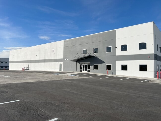
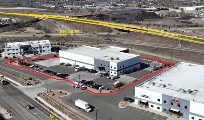
Property Record
1350 W 62Nd Ave, Denver, CO 80221

Current Lease Availabilities
Property Detail
1350 W 62Nd Ave
Denver-Aurora-Centennial, CO
PECOS I-76 INDUSTRIAL PARK PLAT CORR NO 2 LOT 2
1825-09-1-04-036
ADAMS
Miscellaneous
Colorado
B and X Area of moderate flood hazard, usually the area between the limits of the 100-year and 500-year floods.
2
2024
3.84 AC
2025
Northwest Denver
009553
Denver
30,980 SF
NEARBY LISTINGS FOR SALE OR LEASE
DEMOGRAPHICS near 1350 W 62Nd Ave
1 mile
3 mile
5 mile
2024 Total Population
4,132
104,165
394,244
2029 Population
4,337
107,312
402,728
Pop Growth 2024-2029
+ 4.96%
+ 3.02%
+ 2.15%
Average Age
37
38
38
2024 Total Households
1,565
38,507
167,947
HH Growth 2024-2029
+ 4.98%
+ 2.90%
+ 2.18%
Median Household Inc
$103,315
$73,690
$78,227
Avg Household Size
2.60
2.60
2.20
2024 Avg HH Vehicles
2.00
2.00
2.00
Median Home Value
$649,335
$445,459
$460,099
Median Year Built
2005
1966
1976
Nearby Places
Map Layers
Map Styles
 Street
 Aerial
Transit
 Traffic
 Biking
Places
Listings with unknown addresses are not visible on the map
- Restaurants
- Banks
- Shops
- Fitness
- Groceries
PUBLIC TRANSPORTATION
COMMUTER RAIL
Drive
Walk
Distance
1 min
5 min
0.3 mi
Drive
Walk
Distance
6 min
2.1 mi
AIRPORT
Denver International
Drive
Walk
Distance
Denver International
34 min
25.0 mi
Nearby Properties
Address
Land Use
TOTAL SIZE
Lot Size
Zoning
Address
Land Use
TOTAL SIZE
Lot Size
Zoning
396,741 SF
8.12 AC
A1
Address
Land Use
TOTAL SIZE
Lot Size
Zoning
552,279 SF
2.22 AC
C-RX
Address
Land Use
TOTAL SIZE
Lot Size
Zoning
294,950 SF
6.91 AC
C-RX-12
Address
Land Use
TOTAL SIZE
Lot Size
Zoning
1.64 AC
CMP
Address
Land Use
TOTAL SIZE
Lot Size
Zoning
860,132 SF
68.50 AC
R-5
Address
Land Use
TOTAL SIZE
Lot Size
Zoning
84,252 SF
0.37 AC
I-MX-8
Address
Land Use
TOTAL SIZE
Lot Size
Zoning
138,770 SF
4.64 AC
Address
Land Use
TOTAL SIZE
Lot Size
Zoning
140,328 SF
6.54 AC
PUD
Address
Land Use
TOTAL SIZE
Lot Size
Zoning
25,000 SF
40.42 AC
I-A
Address
Land Use
TOTAL SIZE
Lot Size
Zoning
446,845 SF
10.43 AC
CMP-NWC-G
Address
Land Use
TOTAL SIZE
Lot Size
Zoning
113,385 SF
6.77 AC
Address
Land Use
TOTAL SIZE
Lot Size
Zoning
398,180 SF
33.31 AC
R1C
Address
Land Use
TOTAL SIZE
Lot Size
Zoning
58,750 SF
1.52 AC
Address
Land Use
TOTAL SIZE
Lot Size
Zoning
230,309 SF
0.79 AC
I-MX-8
Address
Land Use
TOTAL SIZE
Lot Size
Zoning
551,915 SF
25.76 AC
Address
Land Use
TOTAL SIZE
Lot Size
Zoning
74,106 SF
3.95 AC
PUD
Address
Land Use
TOTAL SIZE
Lot Size
Zoning
470,539 SF
23.59 AC
Address
Land Use
TOTAL SIZE
Lot Size
Zoning
595,017 SF
11.62 AC
I-B
Address
Land Use
TOTAL SIZE
Lot Size
Zoning
344,689 SF
11.77 AC
I-B
Address
Land Use
TOTAL SIZE
Lot Size
Zoning
110,878 SF
4.65 AC
Address
Land Use
TOTAL SIZE
Lot Size
Zoning
299,498 SF
35.75 AC
C-MX-12
Address
Land Use
TOTAL SIZE
Lot Size
Zoning
727,307 SF
38.44 AC
I-B
Address
Land Use
TOTAL SIZE
Lot Size
Zoning
6,626 SF
0.11 AC
C-RX
Address
Land Use
TOTAL SIZE
Lot Size
Zoning
105,600 SF
1.31 AC
Address
Land Use
TOTAL SIZE
Lot Size
Zoning
48,703 SF
0.42 AC
U-MX
Address
Land Use
TOTAL SIZE
Lot Size
Zoning
419,745 SF
24.75 AC
Address
Land Use
TOTAL SIZE
Lot Size
Zoning
146,217 SF
5.28 AC
I-MX-8
Address
Land Use
TOTAL SIZE
Lot Size
Zoning
390,764 SF
20.19 AC
Address
Land Use
TOTAL SIZE
Lot Size
Zoning
439,200 SF
25.09 AC
Address
Land Use
TOTAL SIZE
Lot Size
Zoning
65,336 SF
2.86 AC
The World's #1 Commercial Real Estate Marketplace
Connect with us
© 2026 CoStar Group
The information above has been obtained from sources believed reliable. While we do not doubt its accuracy we have not verified it and make no guarantee, warranty or representation about it. It is your responsibility to independently confirm its accuracy and completeness. Any projections, opinions, assumptions, or estimates used are for example only and do not represent the current or future performance of the property. The value of this transaction to you depends on tax and other factors which should be evaluated by your tax, financial, and legal advisors. You and your advisors should conduct a careful, independent investigation of the property to determine to your satisfaction the suitability of the property for your needs.