Property Record
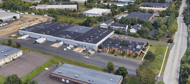
1350 Welsh Rd, North Wales, PA 19454


NEARBY LISTINGS FOR SALE OR LEASE
Property Detail
1350 Welsh Rd
46-00-04243-013
Montgomeryville Buisness Park
Industrialcondominium
ASSESSOR BLOCK-UNIT NUMBER 19-113
X
Montgomery
42091C0278G
Pennsylvania
2024
3.05 AC
2025
East Montgomery Cty
200605
Philadelphia
132,360 SF
Philadelphia-Camden-Wilmington, PA-NJ-DE-MD
DEMOGRAPHICS near 1350 Welsh Rd
1 Mile
3 Mile
5 Mile
2024 Total Population
6,078
52,504
156,623
2029 Population
6,240
53,313
158,804
Pop Growth 2024-2029
+ 2.67%
+ 1.54%
+ 1.39%
Average Age
44
44
43
2024 Total Households
2,233
19,859
59,124
HH Growth 2024-2029
+ 2.64%
+ 1.52%
+ 1.33%
Median Household Inc
$120,057
$121,152
$116,682
Avg Household Size
2.40
2.50
2.60
2024 Avg HH Vehicles
2.00
2.00
2.00
Median Home Value
$618,518
$437,169
$432,712
Median Year Built
1991
1982
1980
Nearby Places
Map Layers
Map Styles
 Street
 Aerial
- Restaurants
- Banks
- Shops
- Fitness
- Groceries
PUBLIC TRANSPORTATION
COMMUTER RAIL
North Wales (R5 - Southeastern Pennsylvania Transportation Authority Regional Rail (SEPTA Regional Rail))
DRIVE
WALK
Distance
North Wales (R5 - Southeastern Pennsylvania Transportation Authority Regional Rail (SEPTA Regional Rail))
8 min
3.3 mi
Pennbrook (R5 - Southeastern Pennsylvania Transportation Authority Regional Rail (SEPTA Regional Rail))
DRIVE
WALK
Distance
Pennbrook (R5 - Southeastern Pennsylvania Transportation Authority Regional Rail (SEPTA Regional Rail))
8 min
3.4 mi
AIRPORT
Philadelphia International
DRIVE
WALK
Distance
Philadelphia International
55 min
32.0 mi
Trenton Mercer
DRIVE
WALK
Distance
Trenton Mercer
52 min
33.4 mi
Lehigh Valley International
DRIVE
WALK
Distance
Lehigh Valley International
61 min
36.4 mi
Freight Ports
Port of Philadelphia
DRIVE
WALK
Distance
Port of Philadelphia
33 min
20.4 mi
SALE & LEASE HISTORY
LISTING DATE
SALE/LEASE

Sep 24, 2016
For Sale
Mar 07, 2017
For Lease
Jan 06, 2020
For Lease
Aug 07, 2017
For Lease
Nearby Properties
Address
Land Use
TOTAL SIZE
Lot Size
Zoning
Address
Land Use
TOTAL SIZE
Lot Size
Zoning
1,744,364 SF
91.78 AC
LI
Address
Land Use
TOTAL SIZE
Lot Size
Zoning
832,797 SF
171.68 AC
A
Address
Land Use
TOTAL SIZE
Lot Size
Zoning
614,768 SF
30.16 AC
R7
Address
Land Use
TOTAL SIZE
Lot Size
Zoning
483,618 SF
142.84 AC
A
Address
Land Use
TOTAL SIZE
Lot Size
Zoning
404,986 SF
22.21 AC
I
Address
Land Use
TOTAL SIZE
Lot Size
Zoning
268,288 SF
30.59 AC
RA
Address
Land Use
TOTAL SIZE
Lot Size
Zoning
1,127,663 SF
14.16 AC
RS
Address
Land Use
TOTAL SIZE
Lot Size
Zoning
657,589 SF
100.81 AC
MF3A
Address
Land Use
TOTAL SIZE
Lot Size
Zoning
262,457 SF
40.75 AC
E
Address
Land Use
TOTAL SIZE
Lot Size
Zoning
422,429 SF
35.90 AC
A
Address
Land Use
TOTAL SIZE
Lot Size
Zoning
319,136 SF
18.35 AC
HDR
Address
Land Use
TOTAL SIZE
Lot Size
Zoning
301,431 SF
41.90 AC
S
Address
Land Use
TOTAL SIZE
Lot Size
Zoning
418,962 SF
37.87 AC
O1
Address
Land Use
TOTAL SIZE
Lot Size
Zoning
464,943 SF
56.24 AC
MF3
Address
Land Use
TOTAL SIZE
Lot Size
Zoning
110,113 SF
13.35 AC
SC1
Address
Land Use
TOTAL SIZE
Lot Size
Zoning
245,104 SF
31.21 AC
C
Address
Land Use
TOTAL SIZE
Lot Size
Zoning
199,368 SF
24.65 AC
RC
Address
Land Use
TOTAL SIZE
Lot Size
Zoning
139,081 SF
15.20 AC
LI
Address
Land Use
TOTAL SIZE
Lot Size
Zoning
59,634 SF
16 AC
A
Address
Land Use
TOTAL SIZE
Lot Size
Zoning
142,336 SF
3.17 AC
RS
Address
Land Use
TOTAL SIZE
Lot Size
Zoning
228,026 SF
24.47 AC
MF3
Address
Land Use
TOTAL SIZE
Lot Size
Zoning
140,582 SF
52.93 AC
R2
Address
Land Use
TOTAL SIZE
Lot Size
Zoning
337,074 SF
12.92 AC
A
Address
Land Use
TOTAL SIZE
Lot Size
Zoning
152,000 SF
154.42 AC
F1
Address
Land Use
TOTAL SIZE
Lot Size
Zoning
233,730 SF
19.10 AC
GA
Address
Land Use
TOTAL SIZE
Lot Size
Zoning
333,600 SF
24.72 AC
LI
Address
Land Use
TOTAL SIZE
Lot Size
Zoning
93,657 SF
27.40 AC
A1
Address
Land Use
TOTAL SIZE
Lot Size
Zoning
105,435 SF
12.70 AC
D2
Address
Land Use
TOTAL SIZE
Lot Size
Zoning
135,540 SF
27.77 AC
A1
Address
Land Use
TOTAL SIZE
Lot Size
Zoning
89,349 SF
18.11 AC
R1
The World's #1 Commercial Real Estate Marketplace
Connect with us
© 2026 CoStar Group
The information above has been obtained from sources believed reliable. While we do not doubt its accuracy we have not verified it and make no guarantee, warranty or representation about it. It is your responsibility to independently confirm its accuracy and completeness. Any projections, opinions, assumptions, or estimates used are for example only and do not represent the current or future performance of the property. The value of this transaction to you depends on tax and other factors which should be evaluated by your tax, financial, and legal advisors. You and your advisors should conduct a careful, independent investigation of the property to determine to your satisfaction the suitability of the property for your needs.