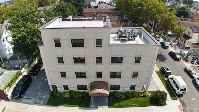
Property Record
13504 102Nd Ave, South Richmond Hill, NY 11419

NEARBY LISTINGS FOR SALE OR LEASE
-
-
-
-
-
-
-
-
-
-
-
-
No Photo
-
-
-
-
-
-
-
-
-
-
-
-
-
View all South Richmond Hill listings for sale on LoopNet.com
Property Detail
13504 102Nd Ave
09503-0068
Dunton Park
Multifamilydwelling
Queens
X
New York
3604970233F
68
2024
0.11 AC
2025
South Richmond Hill
015200
Long Island (New York)
7,266 SF
New York-Jersey City-White Plains, NY-NJ
DEMOGRAPHICS near 13504 102Nd Ave
1 Mile
3 Mile
5 Mile
2024 Total Population
94,634
631,011
1,518,906
2029 Population
86,956
585,763
1,409,244
Pop Growth 2024-2029
(8.11%)
(7.17%)
(7.22%)
Average Age
40
41
41
2024 Total Households
27,855
208,451
508,636
HH Growth 2024-2029
(8.37%)
(7.21%)
(7.39%)
Median Household Inc
$69,653
$74,807
$70,157
Avg Household Size
3.20
2.80
2.80
2024 Avg HH Vehicles
1.00
1.00
1.00
Median Home Value
$679,584
$656,509
$661,990
Median Year Built
1948
1950
1952
Nearby Places
- Restaurants
- Banks
- Shops
- Fitness
- Groceries
PUBLIC TRANSPORTATION
TRANSIT/SUBWAY
Jamaica-Van Wyck (E - New York MTA Subway (The Subway))
DRIVE
WALK
Distance
Jamaica-Van Wyck (E - New York MTA Subway (The Subway))
2 min
14 min
0.7 mi
Sutphin Boulevard-Archer Avenue-Jfk Airport (E - New York MTA Subway (The Subway), J - New York MTA Subway (The Subway), Z - New York MTA Subway (The Subway))
DRIVE
WALK
Distance
Sutphin Boulevard-Archer Avenue-Jfk Airport (E - New York MTA Subway (The Subway), J - New York MTA Subway (The Subway), Z - New York MTA Subway (The Subway))
2 min
15 min
0.8 mi
Jamaica (AirTrain JFK-Jamaica - Port Authority of New York and New Jersey Airtrain (Airtrain))
DRIVE
WALK
Distance
Jamaica (AirTrain JFK-Jamaica - Port Authority of New York and New Jersey Airtrain (Airtrain))
2 min
18 min
0.9 mi
Ozone Park-Lefferts Boulevard (A - New York MTA Subway (The Subway))
DRIVE
WALK
Distance
Ozone Park-Lefferts Boulevard (A - New York MTA Subway (The Subway))
2 min
18 min
0.9 mi
Jamaica Center-Parsons/Archer (E - New York MTA Subway (The Subway), J - New York MTA Subway (The Subway), Z - New York MTA Subway (The Subway))
DRIVE
WALK
Distance
Jamaica Center-Parsons/Archer (E - New York MTA Subway (The Subway), J - New York MTA Subway (The Subway), Z - New York MTA Subway (The Subway))
3 min
20 min
1.1 mi
COMMUTER RAIL
Jamaica Station (Babylon Branch - Long Island Rail Road, Far Rockaway Branch - Long Island Rail Road, Hempstead Branch - Long Island Rail Road, Long Beach Branch - Long Island Rail Road, Montauk Branch - Long Island Rail Road, Oyster Bay Branch - Long Island Rail Road, Port Jefferson Branch - Long Island Rail Road, Ronkonkoma Branch - Long Island Rail Road, West Hempstead Branch - Long Island Rail Road)
DRIVE
WALK
Distance
Jamaica Station (Babylon Branch - Long Island Rail Road, Far Rockaway Branch - Long Island Rail Road, Hempstead Branch - Long Island Rail Road, Long Beach Branch - Long Island Rail Road, Montauk Branch - Long Island Rail Road, Oyster Bay Branch - Long Island Rail Road, Port Jefferson Branch - Long Island Rail Road, Ronkonkoma Branch - Long Island Rail Road, West Hempstead Branch - Long Island Rail Road)
2 min
15 min
0.8 mi
Kew Gardens Station (Babylon Branch - Long Island Rail Road, Hempstead Branch - Long Island Rail Road, Long Beach Branch - Long Island Rail Road, Port Jefferson Branch - Long Island Rail Road)
DRIVE
WALK
Distance
Kew Gardens Station (Babylon Branch - Long Island Rail Road, Hempstead Branch - Long Island Rail Road, Long Beach Branch - Long Island Rail Road, Port Jefferson Branch - Long Island Rail Road)
5 min
2.3 mi
AIRPORT
John F Kennedy International
DRIVE
WALK
Distance
John F Kennedy International
7 min
4.9 mi
LaGuardia
DRIVE
WALK
Distance
LaGuardia
12 min
7.3 mi
Newark Liberty International
DRIVE
WALK
Distance
Newark Liberty International
39 min
27.1 mi
Freight Ports
NY - Red Hook Container Terminal
DRIVE
WALK
Distance
NY - Red Hook Container Terminal
24 min
15.9 mi
SALE & LEASE HISTORY
LISTING DATE
SALE/LEASE

Sep 29, 2020
For Sale
Nearby Properties
Address
Land Use
TOTAL SIZE
Lot Size
Zoning
Address
Land Use
TOTAL SIZE
Lot Size
Zoning
4,528,000 SF
94.27 AC
R4
Address
Land Use
TOTAL SIZE
Lot Size
Zoning
1,845,252 SF
172 AC
C8-1
Address
Land Use
TOTAL SIZE
Lot Size
Zoning
1,069,367 SF
14.65 AC
R4
Address
Land Use
TOTAL SIZE
Lot Size
Zoning
54,170 SF
229.57 AC
PARK
Address
Land Use
TOTAL SIZE
Lot Size
Zoning
1,516,458 SF
5.97 AC
R7-1
Address
Land Use
TOTAL SIZE
Lot Size
Zoning
532,011 SF
2.48 AC
R6
Address
Land Use
TOTAL SIZE
Lot Size
Zoning
15,000 SF
255.27 AC
PARK
Address
Land Use
TOTAL SIZE
Lot Size
Zoning
731,247 SF
56.09 AC
R3-2
Address
Land Use
TOTAL SIZE
Lot Size
Zoning
126.85 AC
PARK
Address
Land Use
TOTAL SIZE
Lot Size
Zoning
738,000 SF
1.92 AC
C6-3
Address
Land Use
TOTAL SIZE
Lot Size
Zoning
291,589 SF
1.55 AC
C6-3
Address
Land Use
TOTAL SIZE
Lot Size
Zoning
2,193 SF
94.72 AC
PARK
Address
Land Use
TOTAL SIZE
Lot Size
Zoning
307,038 SF
7.84 AC
M1-1
Address
Land Use
TOTAL SIZE
Lot Size
Zoning
234,452 SF
2.99 AC
R4
Address
Land Use
TOTAL SIZE
Lot Size
Zoning
320,535 SF
1.52 AC
C4-4A
Address
Land Use
TOTAL SIZE
Lot Size
Zoning
384,249 SF
5.56 AC
R5
Address
Land Use
TOTAL SIZE
Lot Size
Zoning
364,424 SF
C5-3
Address
Land Use
TOTAL SIZE
Lot Size
Zoning
478,384 SF
1.23 AC
C6-3
Address
Land Use
TOTAL SIZE
Lot Size
Zoning
360,000 SF
8.78 AC
R6
Address
Land Use
TOTAL SIZE
Lot Size
Zoning
569,583 SF
2.28 AC
C4-5X
Address
Land Use
TOTAL SIZE
Lot Size
Zoning
230,580 SF
3.41 AC
C8-1
Address
Land Use
TOTAL SIZE
Lot Size
Zoning
460,540 SF
0.69 AC
C6-4
Address
Land Use
TOTAL SIZE
Lot Size
Zoning
535,609 SF
0.82 AC
C6-4
Address
Land Use
TOTAL SIZE
Lot Size
Zoning
208,952 SF
9.03 AC
M1-1
Address
Land Use
TOTAL SIZE
Lot Size
Zoning
4,279,575 SF
144.16 AC
PARK
Address
Land Use
TOTAL SIZE
Lot Size
Zoning
107,000 SF
1.84 AC
R6
Address
Land Use
TOTAL SIZE
Lot Size
Zoning
348,320 SF
6.79 AC
C4-4
Address
Land Use
TOTAL SIZE
Lot Size
Zoning
552,216 SF
9.41 AC
R4
Address
Land Use
TOTAL SIZE
Lot Size
Zoning
240,000 SF
14.50 AC
R4
Address
Land Use
TOTAL SIZE
Lot Size
Zoning
183,070 SF
4.47 AC
M1-1
The World's #1 Commercial Real Estate Marketplace
Connect with us
© 2025 CoStar Group
The information above has been obtained from sources believed reliable. While we do not doubt its accuracy we have not verified it and make no guarantee, warranty or representation about it. It is your responsibility to independently confirm its accuracy and completeness. Any projections, opinions, assumptions, or estimates used are for example only and do not represent the current or future performance of the property. The value of this transaction to you depends on tax and other factors which should be evaluated by your tax, financial, and legal advisors. You and your advisors should conduct a careful, independent investigation of the property to determine to your satisfaction the suitability of the property for your needs.