Property Record
1353 Highway 183, Leander, TX 78641

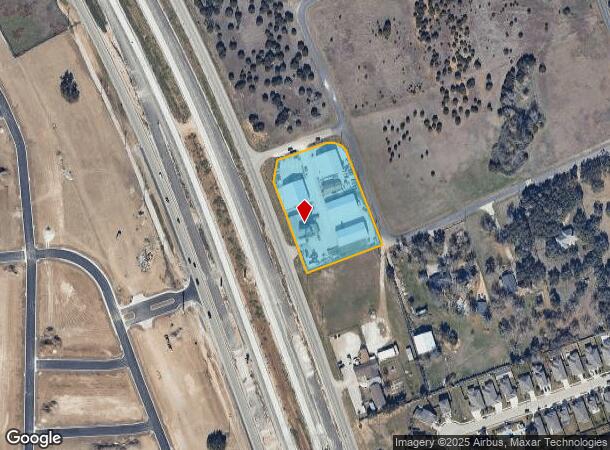

Property Detail
1353 Highway 183
Austin-Round Rock-San Marcos, TX
Baker Estates
R032273
S3106 - BAKER ESTATES, LOT B PT, ACRES 2.34
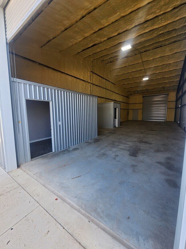
Commercialnec
Williamson
X
Texas
48491C0275E
b
2024
2.34 AC
2025
Georgetown
020329
Austin
27,014 SF
NEARBY LISTINGS FOR SALE OR LEASE
DEMOGRAPHICS near 1353 Highway 183
1 mile
3 mile
5 mile
2024 Total Population
6,180
25,946
70,993
2029 Population
7,981
33,466
92,024
Pop Growth 2024-2029
+ 29.14%
+ 28.98%
+ 29.62%
Average Age
33
35
36
2024 Total Households
2,036
8,631
24,331
HH Growth 2024-2029
+ 29.57%
+ 29.58%
+ 30.19%
Median Household Inc
$96,957
$110,034
$111,625
Avg Household Size
3.00
3.00
2.90
2024 Avg HH Vehicles
2.00
2.00
2.00
Median Home Value
$277,061
$391,625
$424,168
Median Year Built
2011
2011
2010
Nearby Places
Map Layers
Map Styles
 Street
 Aerial
Transit
 Traffic
 Biking
Places
Listings with unknown addresses are not visible on the map
- Restaurants
- Banks
- Shops
- Fitness
- Groceries
PUBLIC TRANSPORTATION
AIRPORT
Robert Gray AAF
Drive
Walk
Distance
Robert Gray AAF
56 min
35.7 mi
Austin-Bergstrom International
Drive
Walk
Distance
Austin-Bergstrom International
54 min
41.6 mi
Killeen Municipal
Drive
Walk
Distance
Killeen Municipal
54 min
41.8 mi
SALE & LEASE HISTORY
LISTING DATE
SALE/LEASE

Apr 03, 2024
For Lease
Nearby Properties
Address
Land Use
TOTAL SIZE
Lot Size
Zoning
Address
Land Use
TOTAL SIZE
Lot Size
Zoning
454,000 SF
58.85 AC
Address
Land Use
TOTAL SIZE
Lot Size
Zoning
435,000 SF
88.70 AC
Address
Land Use
TOTAL SIZE
Lot Size
Zoning
325,045 SF
11.40 AC
Address
Land Use
TOTAL SIZE
Lot Size
Zoning
156,000 SF
67.68 AC
Address
Land Use
TOTAL SIZE
Lot Size
Zoning
312,374 SF
15.77 AC
Address
Land Use
TOTAL SIZE
Lot Size
Zoning
232,172 SF
10.43 AC
Address
Land Use
TOTAL SIZE
Lot Size
Zoning
286,888 SF
20.68 AC
Address
Land Use
TOTAL SIZE
Lot Size
Zoning
193,600 SF
70.78 AC
Address
Land Use
TOTAL SIZE
Lot Size
Zoning
247,584 SF
18.45 AC
Address
Land Use
TOTAL SIZE
Lot Size
Zoning
Address
Land Use
TOTAL SIZE
Lot Size
Zoning
1,971 SF
52.04 AC
Address
Land Use
TOTAL SIZE
Lot Size
Zoning
109,663 SF
19.54 AC
Address
Land Use
TOTAL SIZE
Lot Size
Zoning
256,008 SF
15.88 AC
Address
Land Use
TOTAL SIZE
Lot Size
Zoning
35,223 SF
9.75 AC
Address
Land Use
TOTAL SIZE
Lot Size
Zoning
37,809 SF
6.26 AC
Address
Land Use
TOTAL SIZE
Lot Size
Zoning
127,329 SF
32.79 AC
Address
Land Use
TOTAL SIZE
Lot Size
Zoning
39,180 SF
9.28 AC
Address
Land Use
TOTAL SIZE
Lot Size
Zoning
60,305 SF
0.87 AC
Address
Land Use
TOTAL SIZE
Lot Size
Zoning
46,979 SF
5.56 AC
Address
Land Use
TOTAL SIZE
Lot Size
Zoning
308,888 SF
34.18 AC
Address
Land Use
TOTAL SIZE
Lot Size
Zoning
24,080 SF
16.43 AC
Address
Land Use
TOTAL SIZE
Lot Size
Zoning
111,000 SF
15.27 AC
Address
Land Use
TOTAL SIZE
Lot Size
Zoning
72,209 SF
14.16 AC
Address
Land Use
TOTAL SIZE
Lot Size
Zoning
13.56 AC
Address
Land Use
TOTAL SIZE
Lot Size
Zoning
41,795 SF
16 AC
Address
Land Use
TOTAL SIZE
Lot Size
Zoning
2,952 SF
131.47 AC
Address
Land Use
TOTAL SIZE
Lot Size
Zoning
101,012 SF
3.60 AC
Address
Land Use
TOTAL SIZE
Lot Size
Zoning
251.73 AC
Address
Land Use
TOTAL SIZE
Lot Size
Zoning
27,212 SF
3.25 AC
Address
Land Use
TOTAL SIZE
Lot Size
Zoning
25,928 SF
15.13 AC
The World's #1 Commercial Real Estate Marketplace
Connect with us
© 2026 CoStar Group
The information above has been obtained from sources believed reliable. While we do not doubt its accuracy we have not verified it and make no guarantee, warranty or representation about it. It is your responsibility to independently confirm its accuracy and completeness. Any projections, opinions, assumptions, or estimates used are for example only and do not represent the current or future performance of the property. The value of this transaction to you depends on tax and other factors which should be evaluated by your tax, financial, and legal advisors. You and your advisors should conduct a careful, independent investigation of the property to determine to your satisfaction the suitability of the property for your needs.