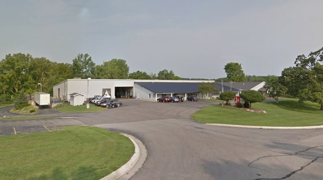
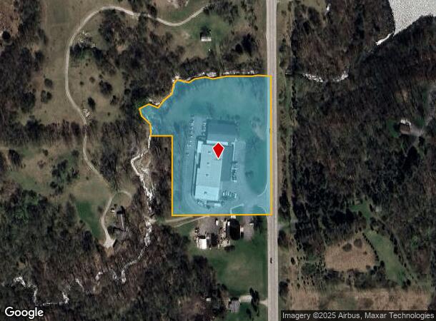
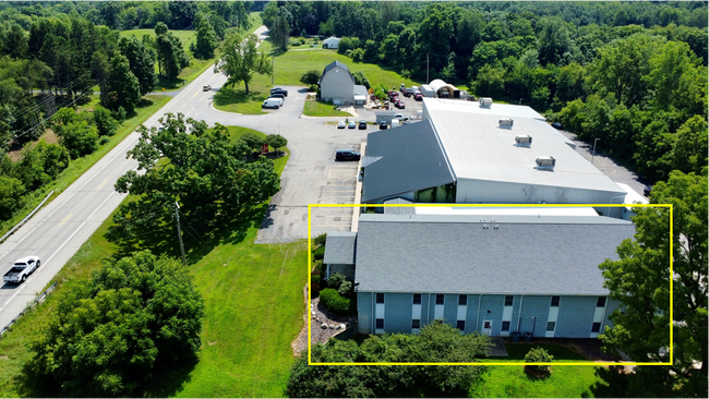
Property Record
1351 N M 43 Hwy, Hastings, MI 49058
This Property Is For Sale
Current Lease Availabilities
NEARBY LISTINGS FOR SALE OR LEASE
Property Detail
1351 N M 43 Hwy
06-006-013-00
COM SE COR SEC 6 T3N R8W, TH NO*21?20?W 1657.48FT ALG EL/SD SEC TO POB; TH S89*3O?40?W 400FT, TH NO*21'20"W 320FT, TH W 100FT +/- TO CREEK, TH NE'LY ON C/L SAND CREEK TO E LI SD SEC, TH S0*21'20?E 549FT +/- TO POB. 5.27 ACRES +/-
Manufacturinglight
Barry
A
Michigan
26015C0191C
5.27 AC
2023
Barry County
2025
West Michigan
011402
Grand Rapids-Wyoming-Kentwood, MI
31,578 SF
DEMOGRAPHICS near 1351 N M 43 Hwy
1 Mile
3 Mile
5 Mile
2024 Total Population
1,414
11,087
15,219
2029 Population
1,476
11,608
15,954
Pop Growth 2024-2029
+ 4.38%
+ 4.70%
+ 4.83%
Average Age
45
42
41
2024 Total Households
600
4,510
6,047
HH Growth 2024-2029
+ 4.33%
+ 4.70%
+ 4.81%
Median Household Inc
$66,696
$63,180
$67,893
Avg Household Size
2.30
2.40
2.50
2024 Avg HH Vehicles
2.00
2.00
2.00
Median Home Value
$272,900
$221,363
$238,349
Median Year Built
1974
1966
1968
Nearby Places
Map Layers
Map Styles
 Street
 Aerial
- Restaurants
- Banks
- Shops
- Fitness
- Groceries
PUBLIC TRANSPORTATION
AIRPORT
Gerald R Ford International
DRIVE
WALK
Distance
Gerald R Ford International
44 min
25.8 mi
Kalamazoo/Battle Creek International
DRIVE
WALK
Distance
Kalamazoo/Battle Creek International
66 min
38.8 mi
Nearby Properties
Address
Land Use
TOTAL SIZE
Lot Size
Zoning
Address
Land Use
TOTAL SIZE
Lot Size
Zoning
156,011 SF
6.76 AC
A-O
Address
Land Use
TOTAL SIZE
Lot Size
Zoning
100,000 SF
Address
Land Use
TOTAL SIZE
Lot Size
Zoning
231,772 SF
13.51 AC
D-2
Address
Land Use
TOTAL SIZE
Lot Size
Zoning
92,343 SF
1.21 AC
PUD
Address
Land Use
TOTAL SIZE
Lot Size
Zoning
4,646 SF
1.04 AC
B-2
Address
Land Use
TOTAL SIZE
Lot Size
Zoning
24,938 SF
2.01 AC
B-1
Address
Land Use
TOTAL SIZE
Lot Size
Zoning
58,800 SF
4 AC
PUD
Address
Land Use
TOTAL SIZE
Lot Size
Zoning
39,800 SF
3.10 AC
MU
Address
Land Use
TOTAL SIZE
Lot Size
Zoning
79,428 SF
8.97 AC
B-2
Address
Land Use
TOTAL SIZE
Lot Size
Zoning
95,899 SF
23.29 AC
MU
Address
Land Use
TOTAL SIZE
Lot Size
Zoning
202,882 SF
12.63 AC
D-2
Address
Land Use
TOTAL SIZE
Lot Size
Zoning
48,764 SF
64.10 AC
AR
Address
Land Use
TOTAL SIZE
Lot Size
Zoning
42,369 SF
11.77 AC
A-O
Address
Land Use
TOTAL SIZE
Lot Size
Zoning
29,759 SF
2.69 AC
A-1
Address
Land Use
TOTAL SIZE
Lot Size
Zoning
25.23 AC
PUD
Address
Land Use
TOTAL SIZE
Lot Size
Zoning
1,300 SF
31.80 AC
MU
Address
Land Use
TOTAL SIZE
Lot Size
Zoning
81,110 SF
14.12 AC
LI
Address
Land Use
TOTAL SIZE
Lot Size
Zoning
18,804 SF
3.67 AC
B-2
Address
Land Use
TOTAL SIZE
Lot Size
Zoning
91,080 SF
Address
Land Use
TOTAL SIZE
Lot Size
Zoning
Address
Land Use
TOTAL SIZE
Lot Size
Zoning
28,021 SF
3.54 AC
PUD
Address
Land Use
TOTAL SIZE
Lot Size
Zoning
81,563 SF
7.66 AC
Address
Land Use
TOTAL SIZE
Lot Size
Zoning
40,624 SF
3.31 AC
A-O
Address
Land Use
TOTAL SIZE
Lot Size
Zoning
28,392 SF
1.90 AC
PUD
Address
Land Use
TOTAL SIZE
Lot Size
Zoning
58,694 SF
9.29 AC
LI
Address
Land Use
TOTAL SIZE
Lot Size
Zoning
13,378 SF
5.89 AC
PUD
Address
Land Use
TOTAL SIZE
Lot Size
Zoning
14,144 SF
1.06 AC
B-4
Address
Land Use
TOTAL SIZE
Lot Size
Zoning
18,120 SF
0.44 AC
A-1
Address
Land Use
TOTAL SIZE
Lot Size
Zoning
14,276 SF
3.62 AC
MU
The World's #1 Commercial Real Estate Marketplace
Connect with us
© 2026 CoStar Group
The information above has been obtained from sources believed reliable. While we do not doubt its accuracy we have not verified it and make no guarantee, warranty or representation about it. It is your responsibility to independently confirm its accuracy and completeness. Any projections, opinions, assumptions, or estimates used are for example only and do not represent the current or future performance of the property. The value of this transaction to you depends on tax and other factors which should be evaluated by your tax, financial, and legal advisors. You and your advisors should conduct a careful, independent investigation of the property to determine to your satisfaction the suitability of the property for your needs.