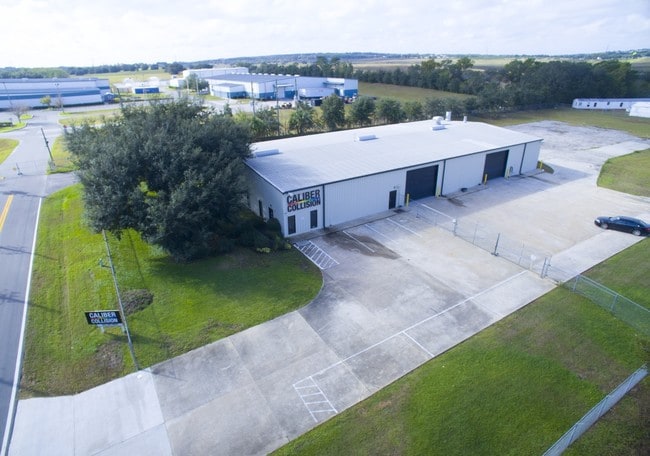
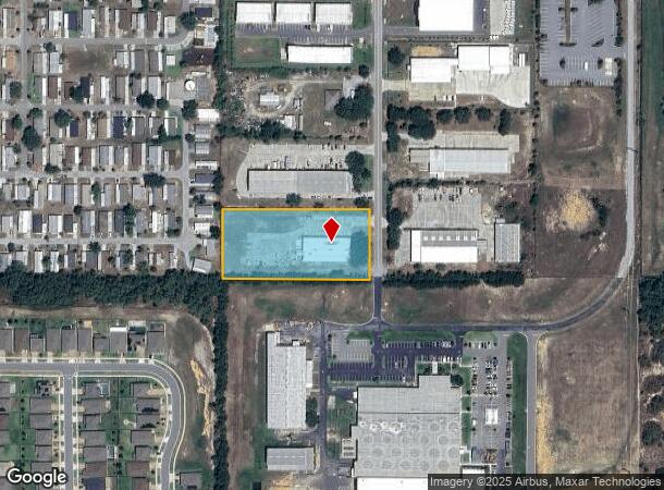
Property Record
13511 Granville Ave, Clermont, FL 34711

NEARBY LISTINGS FOR SALE OR LEASE
Property Detail
13511 Granville Ave
Orlando-Kissimmee-Sanford, FL
Lake Highlands
09-22-26-1100-025-00007
LAKE HIGHLANDS 26-22-26 BEG AT SW COR OF TRACT 25 RUN N 00-56-04 W 220 FT N 89-36-38 E 465.87 FT S 00-53-49 E 220 FT S 89-14-45 W 466.01 FT TO POB BEING PART OF TRACT 25 N 1/2 OF VACATED ST LYING S OF PARCEL PB 3 PG 52 ORB 6481 PG 2434
Autorepair
Lake
X
Florida
12095C0200H
25
2024
2.34 AC
2026
Lake County
031306
Orlando
11,250 SF
DEMOGRAPHICS near 13511 Granville Ave
1 Mile
3 Mile
5 Mile
2024 Total Population
6,299
41,160
99,695
2029 Population
7,563
47,974
114,978
Pop Growth 2024-2029
+ 20.07%
+ 16.55%
+ 15.33%
Average Age
40
43
41
2024 Total Households
2,364
15,777
36,326
HH Growth 2024-2029
+ 20.01%
+ 16.47%
+ 15.29%
Median Household Inc
$88,908
$85,749
$87,060
Avg Household Size
2.60
2.60
2.70
2024 Avg HH Vehicles
2.00
2.00
2.00
Median Home Value
$337,846
$327,616
$343,902
Median Year Built
2009
2006
2005
Nearby Places
Map Layers
Map Styles
 Street
 Aerial
- Restaurants
- Banks
- Shops
- Fitness
- Groceries
PUBLIC TRANSPORTATION
AIRPORT
Orlando International
DRIVE
WALK
Distance
Orlando International
40 min
29.5 mi
Orlando Sanford International
DRIVE
WALK
Distance
Orlando Sanford International
60 min
47.0 mi
Freight Ports
Port of Tampa Bay
DRIVE
WALK
Distance
Port of Tampa Bay
104 min
81.5 mi
Nearby Properties
Address
Land Use
TOTAL SIZE
Lot Size
Zoning
Address
Land Use
TOTAL SIZE
Lot Size
Zoning
505,404 SF
16.10 AC
PUD
Address
Land Use
TOTAL SIZE
Lot Size
Zoning
425,675 SF
25.23 AC
Address
Land Use
TOTAL SIZE
Lot Size
Zoning
403,970 SF
30.99 AC
PUD
Address
Land Use
TOTAL SIZE
Lot Size
Zoning
387,535 SF
22.94 AC
PUD
Address
Land Use
TOTAL SIZE
Lot Size
Zoning
285,581 SF
19.34 AC
CFD
Address
Land Use
TOTAL SIZE
Lot Size
Zoning
306,892 SF
21.96 AC
A
Address
Land Use
TOTAL SIZE
Lot Size
Zoning
326,899 SF
20.77 AC
Address
Land Use
TOTAL SIZE
Lot Size
Zoning
299,214 SF
25.01 AC
PUD
Address
Land Use
TOTAL SIZE
Lot Size
Zoning
321,012 SF
22.55 AC
PUD
Address
Land Use
TOTAL SIZE
Lot Size
Zoning
2,000 SF
35.96 AC
PUD
Address
Land Use
TOTAL SIZE
Lot Size
Zoning
269,594 SF
25.23 AC
PUD
Address
Land Use
TOTAL SIZE
Lot Size
Zoning
179,290 SF
23.79 AC
Address
Land Use
TOTAL SIZE
Lot Size
Zoning
212,649 SF
4.20 AC
Address
Land Use
TOTAL SIZE
Lot Size
Zoning
192,907 SF
16.43 AC
PUD
Address
Land Use
TOTAL SIZE
Lot Size
Zoning
2,000 SF
26.79 AC
PUD
Address
Land Use
TOTAL SIZE
Lot Size
Zoning
118.31 AC
P-D
Address
Land Use
TOTAL SIZE
Lot Size
Zoning
273,592 SF
91.55 AC
R6
Address
Land Use
TOTAL SIZE
Lot Size
Zoning
133,767 SF
19.42 AC
I-1
Address
Land Use
TOTAL SIZE
Lot Size
Zoning
53,054 SF
11.65 AC
Address
Land Use
TOTAL SIZE
Lot Size
Zoning
53,982 SF
24.90 AC
Address
Land Use
TOTAL SIZE
Lot Size
Zoning
78,509 SF
18.68 AC
PUD
Address
Land Use
TOTAL SIZE
Lot Size
Zoning
52,986 SF
18.27 AC
Address
Land Use
TOTAL SIZE
Lot Size
Zoning
2,000 SF
30.62 AC
CFD
Address
Land Use
TOTAL SIZE
Lot Size
Zoning
57,124 SF
7.58 AC
Address
Land Use
TOTAL SIZE
Lot Size
Zoning
106,799 SF
9.06 AC
MP
Address
Land Use
TOTAL SIZE
Lot Size
Zoning
124,634 SF
18.57 AC
Address
Land Use
TOTAL SIZE
Lot Size
Zoning
126,067 SF
9.34 AC
Address
Land Use
TOTAL SIZE
Lot Size
Zoning
62,897 SF
9.81 AC
MP
Address
Land Use
TOTAL SIZE
Lot Size
Zoning
62,794 SF
2.31 AC
Address
Land Use
TOTAL SIZE
Lot Size
Zoning
44,019 SF
9.39 AC
PUD
The World's #1 Commercial Real Estate Marketplace
Connect with us
© 2025 CoStar Group
The information above has been obtained from sources believed reliable. While we do not doubt its accuracy we have not verified it and make no guarantee, warranty or representation about it. It is your responsibility to independently confirm its accuracy and completeness. Any projections, opinions, assumptions, or estimates used are for example only and do not represent the current or future performance of the property. The value of this transaction to you depends on tax and other factors which should be evaluated by your tax, financial, and legal advisors. You and your advisors should conduct a careful, independent investigation of the property to determine to your satisfaction the suitability of the property for your needs.