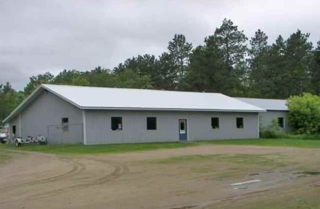
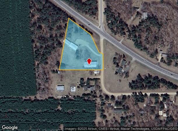
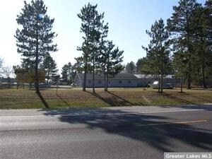
Property Record
13515 Egret Rd, Park Rapids, MN 56470
NEARBY LISTINGS FOR SALE OR LEASE
-
-
View all Park Rapids listings for sale on LoopNet.com
Property Detail
13515 Egret Rd
Other Market Areas
Firehammer Estates
27.73.00100
FIREHAMMER ESTATES LOT-001 BLOCK-001 2.88 AC
Commercialnec
Hubbard
2025
Minnesota
2024
1
070500
2.88 AC
2,800 SF
Minnesota North Area
DEMOGRAPHICS near 13515 Egret Rd
1 Mile
3 Mile
5 Mile
2024 Total Population
344
4,543
6,456
2029 Population
363
4,741
6,809
Pop Growth 2024-2029
+ 5.52%
+ 4.36%
+ 5.47%
Average Age
42
42
43
2024 Total Households
136
1,969
2,760
HH Growth 2024-2029
+ 5.15%
+ 4.06%
+ 5.22%
Median Household Inc
$71,249
$48,662
$55,340
Avg Household Size
2.50
2.20
2.20
2024 Avg HH Vehicles
2.00
2.00
2.00
Median Home Value
$250,000
$214,748
$236,298
Median Year Built
1980
1976
1978
Nearby Places
Map Layers
Map Styles
 Street
 Aerial
- Restaurants
- Banks
- Shops
- Fitness
- Groceries
Nearby Properties
Address
Land Use
TOTAL SIZE
Lot Size
Zoning
Address
Land Use
TOTAL SIZE
Lot Size
Zoning
260,000 SF
112.34 AC
Address
Land Use
TOTAL SIZE
Lot Size
Zoning
120,068 SF
4.33 AC
Address
Land Use
TOTAL SIZE
Lot Size
Zoning
187,428 SF
50.08 AC
Address
Land Use
TOTAL SIZE
Lot Size
Zoning
14,795 SF
4.15 AC
Address
Land Use
TOTAL SIZE
Lot Size
Zoning
60,517 SF
0.69 AC
Address
Land Use
TOTAL SIZE
Lot Size
Zoning
113,762 SF
20.64 AC
Address
Land Use
TOTAL SIZE
Lot Size
Zoning
19,500 SF
120 AC
Address
Land Use
TOTAL SIZE
Lot Size
Zoning
22,680 SF
4.57 AC
Address
Land Use
TOTAL SIZE
Lot Size
Zoning
39,570 SF
0.79 AC
Address
Land Use
TOTAL SIZE
Lot Size
Zoning
94,539 SF
4.67 AC
Address
Land Use
TOTAL SIZE
Lot Size
Zoning
14,848 SF
0.48 AC
Address
Land Use
TOTAL SIZE
Lot Size
Zoning
66,173 SF
1.33 AC
Address
Land Use
TOTAL SIZE
Lot Size
Zoning
49,560 SF
3.54 AC
Address
Land Use
TOTAL SIZE
Lot Size
Zoning
54,040 SF
2.50 AC
Address
Land Use
TOTAL SIZE
Lot Size
Zoning
36,025 SF
1.28 AC
Address
Land Use
TOTAL SIZE
Lot Size
Zoning
33,320 SF
4.80 AC
Address
Land Use
TOTAL SIZE
Lot Size
Zoning
24,441 SF
1.68 AC
Address
Land Use
TOTAL SIZE
Lot Size
Zoning
116,970 SF
10.42 AC
Address
Land Use
TOTAL SIZE
Lot Size
Zoning
19,280 SF
27.80 AC
Address
Land Use
TOTAL SIZE
Lot Size
Zoning
28,330 SF
2.50 AC
Address
Land Use
TOTAL SIZE
Lot Size
Zoning
5,058 SF
2.23 AC
Address
Land Use
TOTAL SIZE
Lot Size
Zoning
21,478 SF
4.61 AC
Address
Land Use
TOTAL SIZE
Lot Size
Zoning
27,126 SF
2.58 AC
Address
Land Use
TOTAL SIZE
Lot Size
Zoning
27,092 SF
2.54 AC
Address
Land Use
TOTAL SIZE
Lot Size
Zoning
18,250 SF
0.32 AC
Address
Land Use
TOTAL SIZE
Lot Size
Zoning
18,121 SF
0.32 AC
Address
Land Use
TOTAL SIZE
Lot Size
Zoning
22,245 SF
10.20 AC
Address
Land Use
TOTAL SIZE
Lot Size
Zoning
2,384 SF
13.48 AC
Address
Land Use
TOTAL SIZE
Lot Size
Zoning
36,146 SF
2.74 AC
The World's #1 Commercial Real Estate Marketplace
Connect with us
© 2026 CoStar Group
The information above has been obtained from sources believed reliable. While we do not doubt its accuracy we have not verified it and make no guarantee, warranty or representation about it. It is your responsibility to independently confirm its accuracy and completeness. Any projections, opinions, assumptions, or estimates used are for example only and do not represent the current or future performance of the property. The value of this transaction to you depends on tax and other factors which should be evaluated by your tax, financial, and legal advisors. You and your advisors should conduct a careful, independent investigation of the property to determine to your satisfaction the suitability of the property for your needs.