Property Record
13519 Remlap Dr, Remlap, AL 35133

NEARBY LISTINGS FOR SALE OR LEASE
-
-
View all Remlap listings for sale on LoopNet.com
Property Detail
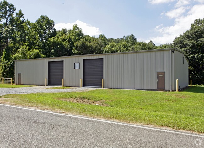
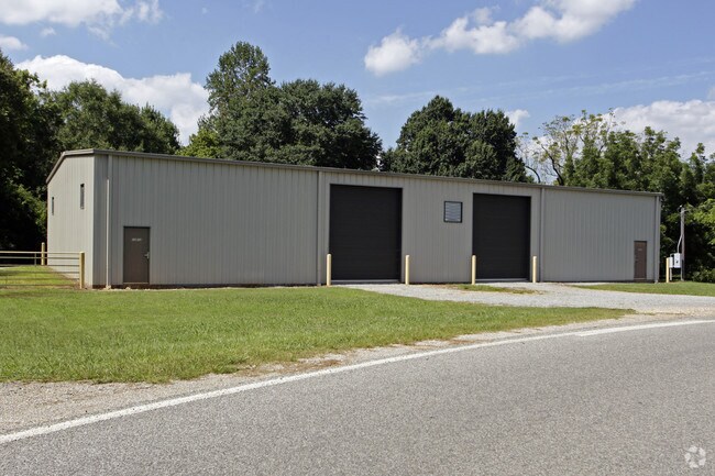
13519 Remlap Dr
28-08-34-0-000-024.001
COM SE COR SE/SW W 116 NW 1145TO W R/W HWY 75 & POB CONT NW 196 NE 158 SE 151 TO HWY SW ALG HWY 149 TO POB--
Distributionwarehouseregional
Blount
X
Alabama
01009C0450F
0.60 AC
2025
Blount County
2024
Birmingham
050701
Birmingham-Hoover, AL
6,000 SF
DEMOGRAPHICS near 13519 Remlap Dr
1 Mile
3 Mile
5 Mile
2024 Total Population
843
4,374
15,347
2029 Population
843
4,326
15,169
Pop Growth 2024-2029
0.00%
(1.10%)
(1.16%)
Average Age
41
43
41
2024 Total Households
307
1,654
5,728
HH Growth 2024-2029
0.00%
(1.15%)
(1.20%)
Median Household Inc
$60,402
$64,000
$66,758
Avg Household Size
2.70
2.60
2.60
2024 Avg HH Vehicles
2.00
2.00
2.00
Median Home Value
$172,424
$174,763
$163,280
Median Year Built
1987
1984
1989
Nearby Places
Map Layers
Map Styles
 Street
 Aerial
- Restaurants
- Banks
- Shops
- Fitness
- Groceries
PUBLIC TRANSPORTATION
AIRPORT
Birmingham-Shuttlesworth International
DRIVE
WALK
Distance
Birmingham-Shuttlesworth International
31 min
18.9 mi
Freight Ports
Port of Mobile
DRIVE
WALK
Distance
Port of Mobile
312 min
277.8 mi
Nearby Properties
Address
Land Use
TOTAL SIZE
Lot Size
Zoning
Address
Land Use
TOTAL SIZE
Lot Size
Zoning
45,806 SF
9 AC
INST
Address
Land Use
TOTAL SIZE
Lot Size
Zoning
25,400 SF
7.42 AC
I
Address
Land Use
TOTAL SIZE
Lot Size
Zoning
3,540 SF
0.72 AC
C1
Address
Land Use
TOTAL SIZE
Lot Size
Zoning
9,100 SF
1.04 AC
Address
Land Use
TOTAL SIZE
Lot Size
Zoning
8,507 SF
90 AC
C3-A
Address
Land Use
TOTAL SIZE
Lot Size
Zoning
6,027 SF
2.45 AC
R1
Address
Land Use
TOTAL SIZE
Lot Size
Zoning
11,799 SF
2.33 AC
INST
Address
Land Use
TOTAL SIZE
Lot Size
Zoning
21,710 SF
4.41 AC
I
Address
Land Use
TOTAL SIZE
Lot Size
Zoning
5,184 SF
4.60 AC
INST
Address
Land Use
TOTAL SIZE
Lot Size
Zoning
5,928 SF
0.30 AC
C1
Address
Land Use
TOTAL SIZE
Lot Size
Zoning
3,660 SF
2.52 AC
C1
Address
Land Use
TOTAL SIZE
Lot Size
Zoning
1,500 SF
1.80 AC
Address
Land Use
TOTAL SIZE
Lot Size
Zoning
3,514 SF
1.27 AC
INST
Address
Land Use
TOTAL SIZE
Lot Size
Zoning
2,280 SF
0.70 AC
C1
Address
Land Use
TOTAL SIZE
Lot Size
Zoning
1,606 SF
2.35 AC
A1
Address
Land Use
TOTAL SIZE
Lot Size
Zoning
184 AC
Address
Land Use
TOTAL SIZE
Lot Size
Zoning
756 SF
40 AC
U1
Address
Land Use
TOTAL SIZE
Lot Size
Zoning
960 SF
1.70 AC
Address
Land Use
TOTAL SIZE
Lot Size
Zoning
1,456 SF
2.64 AC
A1-C
Address
Land Use
TOTAL SIZE
Lot Size
Zoning
2,050 SF
1.20 AC
A1
Address
Land Use
TOTAL SIZE
Lot Size
Zoning
3,168 SF
1.93 AC
C1
Address
Land Use
TOTAL SIZE
Lot Size
Zoning
2,373 SF
0.95 AC
A1
Address
Land Use
TOTAL SIZE
Lot Size
Zoning
30 AC
A1
Address
Land Use
TOTAL SIZE
Lot Size
Zoning
5,180 SF
0.50 AC
Address
Land Use
TOTAL SIZE
Lot Size
Zoning
3.81 AC
R1
Address
Land Use
TOTAL SIZE
Lot Size
Zoning
20 AC
A1
Address
Land Use
TOTAL SIZE
Lot Size
Zoning
4,300 SF
0.70 AC
I
The World's #1 Commercial Real Estate Marketplace
Connect with us
© 2026 CoStar Group
The information above has been obtained from sources believed reliable. While we do not doubt its accuracy we have not verified it and make no guarantee, warranty or representation about it. It is your responsibility to independently confirm its accuracy and completeness. Any projections, opinions, assumptions, or estimates used are for example only and do not represent the current or future performance of the property. The value of this transaction to you depends on tax and other factors which should be evaluated by your tax, financial, and legal advisors. You and your advisors should conduct a careful, independent investigation of the property to determine to your satisfaction the suitability of the property for your needs.