Property Record
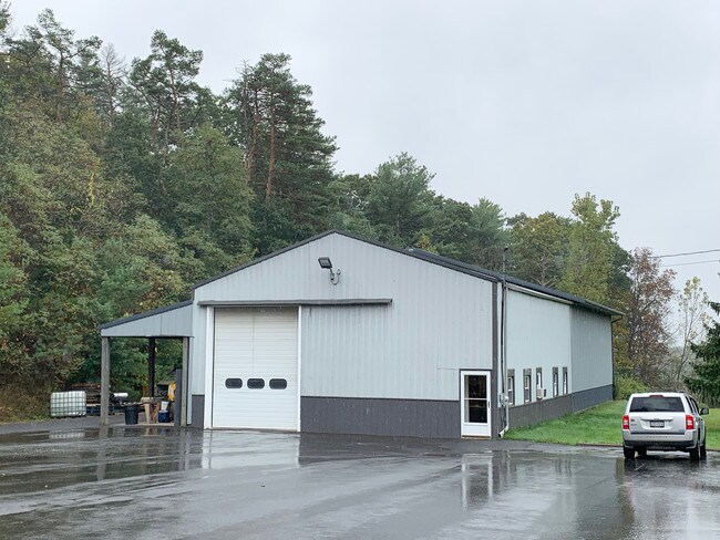
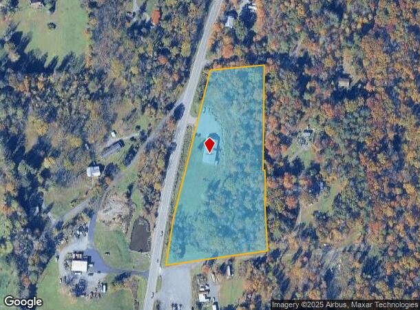
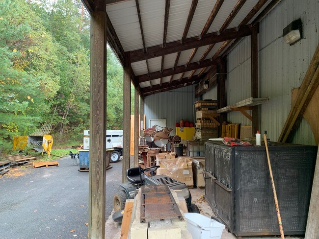
13522 Route 9W, Hannacroix, NY 12087
NEARBY LISTINGS FOR SALE OR LEASE
Property Detail
13522 Route 9W
Warehouse
Greene
X
New York
36039C0115F
9.120
2025
5.76 AC
2024
Greene County
080100
Albany/Schenectady/Troy
4,128 SF
194200-017-003-0002-009-120-0000
DEMOGRAPHICS near 13522 Route 9W
1 Mile
3 Mile
5 Mile
2024 Total Population
237
2,922
11,672
2029 Population
235
2,896
11,626
Pop Growth 2024-2029
(0.84%)
(0.89%)
(0.39%)
Average Age
44
44
43
2024 Total Households
99
1,242
5,029
HH Growth 2024-2029
(1.01%)
(1.05%)
(0.50%)
Median Household Inc
$87,500
$80,765
$70,218
Avg Household Size
2.40
2.30
2.30
2024 Avg HH Vehicles
3.00
2.00
2.00
Median Home Value
$211,538
$218,970
$196,084
Median Year Built
1955
1962
1965
Nearby Places
- Restaurants
- Banks
- Shops
- Fitness
- Groceries
PUBLIC TRANSPORTATION
AIRPORT
Albany International
DRIVE
WALK
Distance
Albany International
42 min
29.9 mi
Freight Ports
Albany, NY Port
DRIVE
WALK
Distance
Albany, NY Port
24 min
16.7 mi
SALE & LEASE HISTORY
LISTING DATE
SALE/LEASE

Nov 05, 2019
For Lease
Nov 05, 2019
For Sale
Nearby Properties
Address
Land Use
TOTAL SIZE
Lot Size
Zoning
Address
Land Use
TOTAL SIZE
Lot Size
Zoning
11,320 SF
26.30 AC
R-2
Address
Land Use
TOTAL SIZE
Lot Size
Zoning
230,900 SF
16.06 AC
05 - COMME
Address
Land Use
TOTAL SIZE
Lot Size
Zoning
164.73 AC
07 - MIXED
Address
Land Use
TOTAL SIZE
Lot Size
Zoning
143.63 AC
Address
Land Use
TOTAL SIZE
Lot Size
Zoning
36,513 SF
2.24 AC
01 - NOT Z
Address
Land Use
TOTAL SIZE
Lot Size
Zoning
86,144 SF
24.70 AC
01 - NOT Z
Address
Land Use
TOTAL SIZE
Lot Size
Zoning
30,720 SF
8.25 AC
01 - NOT Z
Address
Land Use
TOTAL SIZE
Lot Size
Zoning
3,910 SF
13 AC
07 - MIXED
Address
Land Use
TOTAL SIZE
Lot Size
Zoning
6,400 SF
11.73 AC
02 - SINGL
Address
Land Use
TOTAL SIZE
Lot Size
Zoning
1,945 SF
14.52 AC
01 - NOT Z
Address
Land Use
TOTAL SIZE
Lot Size
Zoning
2,896 SF
104 AC
02 - SINGL
Address
Land Use
TOTAL SIZE
Lot Size
Zoning
0.56 AC
05 - COMME
Address
Land Use
TOTAL SIZE
Lot Size
Zoning
11,000 SF
13.20 AC
01 - NOT Z
Address
Land Use
TOTAL SIZE
Lot Size
Zoning
26.42 AC
03 - MULTI
Address
Land Use
TOTAL SIZE
Lot Size
Zoning
7,724 SF
1.54 AC
02 - SINGL
Address
Land Use
TOTAL SIZE
Lot Size
Zoning
4,140 SF
2.03 AC
01 - NOT Z
Address
Land Use
TOTAL SIZE
Lot Size
Zoning
16,050 SF
2.79 AC
01 - NOT Z
Address
Land Use
TOTAL SIZE
Lot Size
Zoning
4,786 SF
141.01 AC
03 - MULTI
Address
Land Use
TOTAL SIZE
Lot Size
Zoning
9,110 SF
2 AC
07 - MIXED
Address
Land Use
TOTAL SIZE
Lot Size
Zoning
155 AC
07 - MIXED
Address
Land Use
TOTAL SIZE
Lot Size
Zoning
76.43 AC
03 - MULTI
Address
Land Use
TOTAL SIZE
Lot Size
Zoning
4,420 SF
0.01 AC
I
Address
Land Use
TOTAL SIZE
Lot Size
Zoning
7.25 AC
03
Address
Land Use
TOTAL SIZE
Lot Size
Zoning
1,260 SF
8.06 AC
01 - NOT Z
Address
Land Use
TOTAL SIZE
Lot Size
Zoning
10,944 SF
0.77 AC
I
Address
Land Use
TOTAL SIZE
Lot Size
Zoning
6,744 SF
2.19 AC
01 - NOT Z
Address
Land Use
TOTAL SIZE
Lot Size
Zoning
2,679 SF
1.85 AC
03 - MULTI
Address
Land Use
TOTAL SIZE
Lot Size
Zoning
1,240 SF
31.40 AC
07 - MIXED
Address
Land Use
TOTAL SIZE
Lot Size
Zoning
2,238 SF
70.40 AC
03 - MULTI
Address
Land Use
TOTAL SIZE
Lot Size
Zoning
103.98 AC
01 - NOT Z
The World's #1 Commercial Real Estate Marketplace
Connect with us
© 2025 CoStar Group
The information above has been obtained from sources believed reliable. While we do not doubt its accuracy we have not verified it and make no guarantee, warranty or representation about it. It is your responsibility to independently confirm its accuracy and completeness. Any projections, opinions, assumptions, or estimates used are for example only and do not represent the current or future performance of the property. The value of this transaction to you depends on tax and other factors which should be evaluated by your tax, financial, and legal advisors. You and your advisors should conduct a careful, independent investigation of the property to determine to your satisfaction the suitability of the property for your needs.