Property Record
715 Filray Ct S, Campbellsville, KY 42718


NEARBY LISTINGS FOR SALE OR LEASE
Property Detail
715 Filray Ct S
Tyler, TX
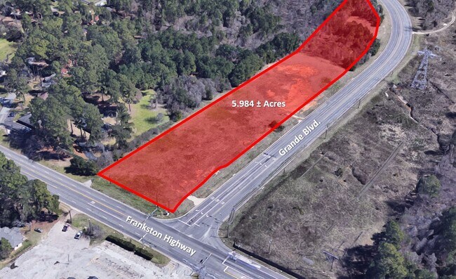
We Grande Addn
1-50000-1672-00-001000
WE GRANDE ADDNBLOCK 1672 LOT 1
Commercialnec
Smith
A
Texas
48423C0365D
1
2024
5.98 AC
2025
Tyler & Longview
002012
Other Market Areas
DEMOGRAPHICS near 715 Filray Ct S
1 Mile
3 Mile
5 Mile
2024 Total Population
1,605
27,631
72,237
2029 Population
1,807
30,139
78,429
Pop Growth 2024-2029
+ 12.59%
+ 9.08%
+ 8.57%
Average Age
44
41
40
2024 Total Households
624
12,448
30,075
HH Growth 2024-2029
+ 12.50%
+ 8.52%
+ 8.00%
Median Household Inc
$66,116
$64,137
$66,410
Avg Household Size
2.40
2.20
2.30
2024 Avg HH Vehicles
2.00
2.00
2.00
Median Home Value
$336,842
$282,941
$239,690
Median Year Built
2003
1996
1986
Nearby Places
Map Layers
Map Styles
 Street
 Aerial
- Restaurants
- Banks
- Shops
- Fitness
- Groceries
PUBLIC TRANSPORTATION
AIRPORT
Tyler Pounds Regional
DRIVE
WALK
Distance
Tyler Pounds Regional
18 min
10.7 mi
Freight Ports
Port of Shreveport
DRIVE
WALK
Distance
Port of Shreveport
129 min
114.4 mi
SALE & LEASE HISTORY
LISTING DATE
SALE/LEASE

Sep 28, 2022
For Sale
Nearby Properties
Address
Land Use
TOTAL SIZE
Lot Size
Zoning
Address
Land Use
TOTAL SIZE
Lot Size
Zoning
11,332 SF
22.07 AC
PMF
Address
Land Use
TOTAL SIZE
Lot Size
Zoning
7,152 SF
19.76 AC
RMF
Address
Land Use
TOTAL SIZE
Lot Size
Zoning
29.58 AC
Address
Land Use
TOTAL SIZE
Lot Size
Zoning
234,762 SF
16.68 AC
Address
Land Use
TOTAL SIZE
Lot Size
Zoning
5,068 SF
18.35 AC
RMF
Address
Land Use
TOTAL SIZE
Lot Size
Zoning
4,333 SF
13.32 AC
Address
Land Use
TOTAL SIZE
Lot Size
Zoning
3,149 SF
16.15 AC
RMF
Address
Land Use
TOTAL SIZE
Lot Size
Zoning
4,349 SF
33.26 AC
RMF
Address
Land Use
TOTAL SIZE
Lot Size
Zoning
237,916 SF
11.17 AC
PMF
Address
Land Use
TOTAL SIZE
Lot Size
Zoning
10.51 AC
Address
Land Use
TOTAL SIZE
Lot Size
Zoning
1,867 SF
13.63 AC
RMF
Address
Land Use
TOTAL SIZE
Lot Size
Zoning
3,968 SF
12.04 AC
RMF
Address
Land Use
TOTAL SIZE
Lot Size
Zoning
126.94 AC
Address
Land Use
TOTAL SIZE
Lot Size
Zoning
3,538 SF
9.51 AC
RMF
Address
Land Use
TOTAL SIZE
Lot Size
Zoning
90,410 SF
4.94 AC
Address
Land Use
TOTAL SIZE
Lot Size
Zoning
3,806 SF
18.86 AC
RMF
Address
Land Use
TOTAL SIZE
Lot Size
Zoning
3,477 SF
9.56 AC
RMF
Address
Land Use
TOTAL SIZE
Lot Size
Zoning
2,936 SF
9.66 AC
RMF
Address
Land Use
TOTAL SIZE
Lot Size
Zoning
17,912 SF
9.06 AC
RMF
Address
Land Use
TOTAL SIZE
Lot Size
Zoning
40,960 SF
8.90 AC
RMF
Address
Land Use
TOTAL SIZE
Lot Size
Zoning
19.16 AC
Address
Land Use
TOTAL SIZE
Lot Size
Zoning
105,407 SF
6.14 AC
C4
Address
Land Use
TOTAL SIZE
Lot Size
Zoning
34,758 SF
9.76 AC
Address
Land Use
TOTAL SIZE
Lot Size
Zoning
15,400 SF
4.41 AC
RMF
Address
Land Use
TOTAL SIZE
Lot Size
Zoning
94,653 SF
6.55 AC
PCD
Address
Land Use
TOTAL SIZE
Lot Size
Zoning
207,849 SF
24.89 AC
Address
Land Use
TOTAL SIZE
Lot Size
Zoning
1,821 SF
8.95 AC
RMF
Address
Land Use
TOTAL SIZE
Lot Size
Zoning
23,796 SF
10.88 AC
RMF
Address
Land Use
TOTAL SIZE
Lot Size
Zoning
13.73 AC
INT
Address
Land Use
TOTAL SIZE
Lot Size
Zoning
85,357 SF
3.17 AC
The World's #1 Commercial Real Estate Marketplace
Connect with us
© 2026 CoStar Group
The information above has been obtained from sources believed reliable. While we do not doubt its accuracy we have not verified it and make no guarantee, warranty or representation about it. It is your responsibility to independently confirm its accuracy and completeness. Any projections, opinions, assumptions, or estimates used are for example only and do not represent the current or future performance of the property. The value of this transaction to you depends on tax and other factors which should be evaluated by your tax, financial, and legal advisors. You and your advisors should conduct a careful, independent investigation of the property to determine to your satisfaction the suitability of the property for your needs.