Property Record
13537 5Th St, Yucaipa, CA 92399
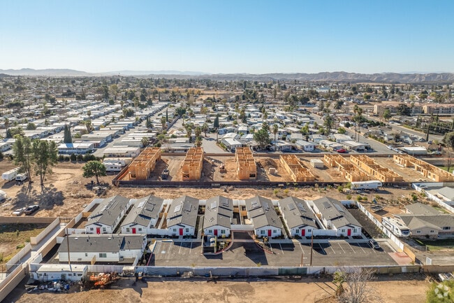
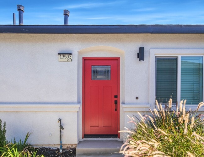
This Property Is For Sale
NEARBY LISTINGS FOR SALE OR LEASE
Property Detail
13537 5Th St
Riverside-San Bernardino-Ontario, CA
Yucaipa Valley
0319-233-59
SUB NO 8 YUCAIPA VALLEY W 180 FT E 300 FT N 2 AC S 3 AC N 1/2 LOT 175 .54 AC M/L
Apartment
San Bernardino
X
California
06065C0118G
175
2024
0.55 AC
2025
Yucaipa
008709
Inland Empire (California)
6,778 SF
DEMOGRAPHICS near 13537 5Th St
1 Mile
3 Mile
5 Mile
2024 Total Population
11,145
55,655
90,366
2029 Population
11,512
57,214
93,895
Pop Growth 2024-2029
+ 3.29%
+ 2.80%
+ 3.91%
Average Age
39
40
40
2024 Total Households
4,032
19,823
31,456
HH Growth 2024-2029
+ 3.13%
+ 2.70%
+ 3.47%
Median Household Inc
$68,738
$78,265
$92,211
Avg Household Size
2.80
2.80
2.80
2024 Avg HH Vehicles
2.00
2.00
2.00
Median Home Value
$373,172
$443,561
$462,066
Median Year Built
1972
1976
1986
Nearby Places
- Restaurants
- Banks
- Shops
- Fitness
- Groceries
PUBLIC TRANSPORTATION
COMMUTER RAIL
Redlands - University Metrolink Station (Metrolink San Bernardino Line - Metrolink Trains)
DRIVE
WALK
Distance
Redlands - University Metrolink Station (Metrolink San Bernardino Line - Metrolink Trains)
11 min
8.3 mi
Redlands - Downtown Metrolink Station (Metrolink San Bernardino Line - Metrolink Trains)
DRIVE
WALK
Distance
Redlands - Downtown Metrolink Station (Metrolink San Bernardino Line - Metrolink Trains)
13 min
9.4 mi
Freight Ports
Port of Long Beach
DRIVE
WALK
Distance
Port of Long Beach
100 min
79.3 mi
Nearby Properties
Address
Land Use
TOTAL SIZE
Lot Size
Zoning
Address
Land Use
TOTAL SIZE
Lot Size
Zoning
810,962 SF
85.23 AC
Address
Land Use
TOTAL SIZE
Lot Size
Zoning
369,838 SF
19.32 AC
Address
Land Use
TOTAL SIZE
Lot Size
Zoning
102,506 SF
4.47 AC
Address
Land Use
TOTAL SIZE
Lot Size
Zoning
82,694 SF
3.41 AC
Address
Land Use
TOTAL SIZE
Lot Size
Zoning
5.47 AC
Address
Land Use
TOTAL SIZE
Lot Size
Zoning
79,299 SF
5.04 AC
Address
Land Use
TOTAL SIZE
Lot Size
Zoning
67,686 SF
4.16 AC
Address
Land Use
TOTAL SIZE
Lot Size
Zoning
56,491 SF
7.50 AC
Address
Land Use
TOTAL SIZE
Lot Size
Zoning
56,491 SF
3.39 AC
Address
Land Use
TOTAL SIZE
Lot Size
Zoning
22,308 SF
1.87 AC
Address
Land Use
TOTAL SIZE
Lot Size
Zoning
24,510 SF
6.88 AC
Address
Land Use
TOTAL SIZE
Lot Size
Zoning
49,320 SF
1.68 AC
Address
Land Use
TOTAL SIZE
Lot Size
Zoning
49,952 SF
4.34 AC
Address
Land Use
TOTAL SIZE
Lot Size
Zoning
29,387 SF
3.21 AC
Address
Land Use
TOTAL SIZE
Lot Size
Zoning
27,627 SF
5.07 AC
Address
Land Use
TOTAL SIZE
Lot Size
Zoning
42,634 SF
1.91 AC
Address
Land Use
TOTAL SIZE
Lot Size
Zoning
111,182 SF
3.11 AC
Address
Land Use
TOTAL SIZE
Lot Size
Zoning
15,980 SF
1.56 AC
Address
Land Use
TOTAL SIZE
Lot Size
Zoning
33.42 AC
Address
Land Use
TOTAL SIZE
Lot Size
Zoning
33,000 SF
2.96 AC
Address
Land Use
TOTAL SIZE
Lot Size
Zoning
41,005 SF
3.27 AC
MIX
Address
Land Use
TOTAL SIZE
Lot Size
Zoning
78,309 SF
7.09 AC
Address
Land Use
TOTAL SIZE
Lot Size
Zoning
29,996 SF
1.86 AC
Address
Land Use
TOTAL SIZE
Lot Size
Zoning
73,670 SF
4.49 AC
Address
Land Use
TOTAL SIZE
Lot Size
Zoning
1,970 SF
6.27 AC
Address
Land Use
TOTAL SIZE
Lot Size
Zoning
41,040 SF
4.70 AC
Address
Land Use
TOTAL SIZE
Lot Size
Zoning
23,227 SF
1.81 AC
Address
Land Use
TOTAL SIZE
Lot Size
Zoning
18,800 SF
4.07 AC
CC
The World's #1 Commercial Real Estate Marketplace
Connect with us
© 2025 CoStar Group
The information above has been obtained from sources believed reliable. While we do not doubt its accuracy we have not verified it and make no guarantee, warranty or representation about it. It is your responsibility to independently confirm its accuracy and completeness. Any projections, opinions, assumptions, or estimates used are for example only and do not represent the current or future performance of the property. The value of this transaction to you depends on tax and other factors which should be evaluated by your tax, financial, and legal advisors. You and your advisors should conduct a careful, independent investigation of the property to determine to your satisfaction the suitability of the property for your needs.