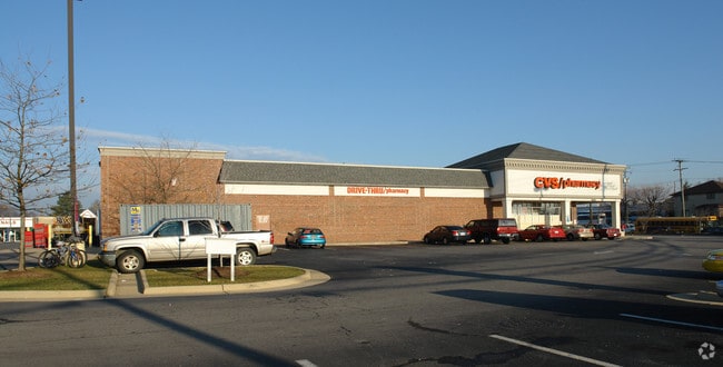
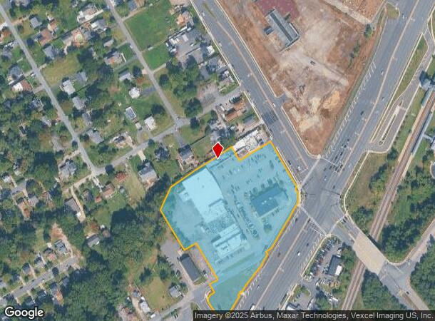
Property Record
13538 Richmond Hwy, Woodbridge, VA 22191
NEARBY LISTINGS FOR SALE OR LEASE
Property Detail
13538 Richmond Hwy
8392-95-5514
PCL A
Regionalshoppingcenterormallwithanchorstore
Prince William
X
Virginia
51059C0370E
5.50 AC
2024
Woodbridge/I-95 Corridor
2025
Washington, DC
900201
Washington-Arlington-Alexandria, DC-VA-MD-WV
59,793 SF
DEMOGRAPHICS near 13538 Richmond Hwy
1 Mile
3 Mile
5 Mile
2024 Total Population
16,344
68,794
186,491
2029 Population
16,877
70,526
189,803
Pop Growth 2024-2029
+ 3.26%
+ 2.52%
+ 1.78%
Average Age
35
36
37
2024 Total Households
5,487
23,666
61,957
HH Growth 2024-2029
+ 3.61%
+ 2.59%
+ 1.76%
Median Household Inc
$86,158
$92,351
$107,514
Avg Household Size
2.90
2.80
2.90
2024 Avg HH Vehicles
2.00
2.00
2.00
Median Home Value
$378,136
$376,223
$400,600
Median Year Built
1990
1986
1988
Nearby Places
Map Layers
Map Styles
 Street
 Aerial
- Restaurants
- Banks
- Shops
- Fitness
- Groceries
PUBLIC TRANSPORTATION
COMMUTER RAIL
Woodbridge (Fredericksburg Line - Virginia Railway Express)
DRIVE
WALK
Distance
Woodbridge (Fredericksburg Line - Virginia Railway Express)
1 min
8 min
0.2 mi
Rippon (Fredericksburg Line - Virginia Railway Express)
DRIVE
WALK
Distance
Rippon (Fredericksburg Line - Virginia Railway Express)
9 min
4.3 mi
AIRPORT
Ronald Reagan Washington Ntl
DRIVE
WALK
Distance
Ronald Reagan Washington Ntl
31 min
20.4 mi
Washington Dulles International
DRIVE
WALK
Distance
Washington Dulles International
52 min
30.0 mi
Freight Ports
Port of Baltimore
DRIVE
WALK
Distance
Port of Baltimore
90 min
61.5 mi
Nearby Properties
Address
Land Use
TOTAL SIZE
Lot Size
Zoning
Address
Land Use
TOTAL SIZE
Lot Size
Zoning
1,402,177 SF
104.72 AC
B1
Address
Land Use
TOTAL SIZE
Lot Size
Zoning
570,195 SF
38.70 AC
OH
Address
Land Use
TOTAL SIZE
Lot Size
Zoning
485,714 SF
82.68 AC
MIXED
Address
Land Use
TOTAL SIZE
Lot Size
Zoning
609,447 SF
44.24 AC
R16
Address
Land Use
TOTAL SIZE
Lot Size
Zoning
872,283 SF
17.34 AC
PMR
Address
Land Use
TOTAL SIZE
Lot Size
Zoning
465,616 SF
6.45 AC
PMR
Address
Land Use
TOTAL SIZE
Lot Size
Zoning
345,910 SF
18.78 AC
PMR
Address
Land Use
TOTAL SIZE
Lot Size
Zoning
337,789 SF
10.02 AC
PMD
Address
Land Use
TOTAL SIZE
Lot Size
Zoning
568,505 SF
7.19 AC
PMR
Address
Land Use
TOTAL SIZE
Lot Size
Zoning
377,248 SF
26.67 AC
R16
Address
Land Use
TOTAL SIZE
Lot Size
Zoning
93,321 SF
26.28 AC
R16
Address
Land Use
TOTAL SIZE
Lot Size
Zoning
175,001 SF
28.60 AC
R16
Address
Land Use
TOTAL SIZE
Lot Size
Zoning
382,173 SF
91.53 AC
A1
Address
Land Use
TOTAL SIZE
Lot Size
Zoning
605,863 SF
14.52 AC
PMD
Address
Land Use
TOTAL SIZE
Lot Size
Zoning
81,628 SF
26.25 AC
R16
Address
Land Use
TOTAL SIZE
Lot Size
Zoning
316,829 SF
8.96 AC
PMR
Address
Land Use
TOTAL SIZE
Lot Size
Zoning
394,404 SF
64.52 AC
RPC
Address
Land Use
TOTAL SIZE
Lot Size
Zoning
354,638 SF
28.32 AC
B1
Address
Land Use
TOTAL SIZE
Lot Size
Zoning
86,869 SF
9.54 AC
PMD
Address
Land Use
TOTAL SIZE
Lot Size
Zoning
376,424 SF
24.48 AC
R16
Address
Land Use
TOTAL SIZE
Lot Size
Zoning
424,533 SF
14.74 AC
R16
Address
Land Use
TOTAL SIZE
Lot Size
Zoning
252,614 SF
21.96 AC
B1
Address
Land Use
TOTAL SIZE
Lot Size
Zoning
434,095 SF
18.64 AC
B1
Address
Land Use
TOTAL SIZE
Lot Size
Zoning
120,620 SF
13.10 AC
596
Address
Land Use
TOTAL SIZE
Lot Size
Zoning
199,448 SF
6.14 AC
R30
Address
Land Use
TOTAL SIZE
Lot Size
Zoning
67,551 SF
12.69 AC
R16
Address
Land Use
TOTAL SIZE
Lot Size
Zoning
223,340 SF
20.64 AC
MIXED
Address
Land Use
TOTAL SIZE
Lot Size
Zoning
170,328 SF
13.21 AC
R16
Address
Land Use
TOTAL SIZE
Lot Size
Zoning
120,203 SF
17.35 AC
MIXED
Address
Land Use
TOTAL SIZE
Lot Size
Zoning
41.11 AC
110
The World's #1 Commercial Real Estate Marketplace
Connect with us
© 2026 CoStar Group
The information above has been obtained from sources believed reliable. While we do not doubt its accuracy we have not verified it and make no guarantee, warranty or representation about it. It is your responsibility to independently confirm its accuracy and completeness. Any projections, opinions, assumptions, or estimates used are for example only and do not represent the current or future performance of the property. The value of this transaction to you depends on tax and other factors which should be evaluated by your tax, financial, and legal advisors. You and your advisors should conduct a careful, independent investigation of the property to determine to your satisfaction the suitability of the property for your needs.