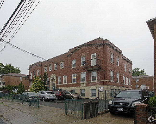
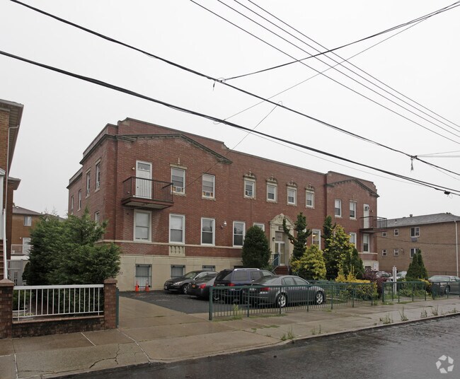
Property Record
1355 84Th St, Brooklyn, NY 11228

NEARBY LISTINGS FOR SALE OR LEASE
Property Detail
1355 84Th St
06309-0048
ID2011090701072001
Publichealthcarefacility
Kings
X
New York
3604970332F
48
2024
0.41 AC
2025
South Brooklyn
015000
Long Island (New York)
17,550 SF
New York-Jersey City-White Plains, NY-NJ
DEMOGRAPHICS near 1355 84Th St
1 Mile
3 Mile
5 Mile
2024 Total Population
94,081
721,085
1,510,490
2029 Population
84,928
667,272
1,415,742
Pop Growth 2024-2029
(9.73%)
(7.46%)
(6.27%)
Average Age
41
39
40
2024 Total Households
31,522
237,964
539,612
HH Growth 2024-2029
(10.34%)
(7.80%)
(6.53%)
Median Household Inc
$71,028
$60,838
$69,793
Avg Household Size
2.90
2.90
2.70
2024 Avg HH Vehicles
1.00
1.00
1.00
Median Home Value
$957,548
$892,650
$803,876
Median Year Built
1946
1947
1948
Nearby Places
Map Layers
Map Styles
 Street
 Aerial
- Restaurants
- Banks
- Shops
- Fitness
- Groceries
PUBLIC TRANSPORTATION
COMMUTER RAIL
Grasmere (Staten Island Railway - New York MTA Subway (The Subway))
DRIVE
WALK
Distance
Grasmere (Staten Island Railway - New York MTA Subway (The Subway))
11 min
5.0 mi
Clifton (Staten Island Railway - New York MTA Subway (The Subway))
DRIVE
WALK
Distance
Clifton (Staten Island Railway - New York MTA Subway (The Subway))
11 min
5.5 mi
AIRPORT
John F Kennedy International
DRIVE
WALK
Distance
John F Kennedy International
31 min
15.3 mi
LaGuardia
DRIVE
WALK
Distance
LaGuardia
30 min
17.3 mi
Newark Liberty International
DRIVE
WALK
Distance
Newark Liberty International
32 min
20.1 mi
Freight Ports
NY - Red Hook Container Terminal
DRIVE
WALK
Distance
NY - Red Hook Container Terminal
11 min
6.2 mi
Nearby Properties
Address
Land Use
TOTAL SIZE
Lot Size
Zoning
Address
Land Use
TOTAL SIZE
Lot Size
Zoning
1,524,659 SF
170.96 AC
R4
Address
Land Use
TOTAL SIZE
Lot Size
Zoning
965,600 SF
6.65 AC
R5
Address
Land Use
TOTAL SIZE
Lot Size
Zoning
460,000 SF
3.21 AC
R6
Address
Land Use
TOTAL SIZE
Lot Size
Zoning
335,800 SF
1.51 AC
R6
Address
Land Use
TOTAL SIZE
Lot Size
Zoning
54.78 AC
PARK
Address
Land Use
TOTAL SIZE
Lot Size
Zoning
1,324,592 SF
5.13 AC
M3-1
Address
Land Use
TOTAL SIZE
Lot Size
Zoning
397,354 SF
0.61 AC
C5-2
Address
Land Use
TOTAL SIZE
Lot Size
Zoning
236,591 SF
207.66 AC
R3-2
Address
Land Use
TOTAL SIZE
Lot Size
Zoning
5,359,400 SF
59.07 AC
M2-1
Address
Land Use
TOTAL SIZE
Lot Size
Zoning
286,000 SF
12.63 AC
PARK
Address
Land Use
TOTAL SIZE
Lot Size
Zoning
689,850 SF
3.08 AC
M3-1
Address
Land Use
TOTAL SIZE
Lot Size
Zoning
301,400 SF
22.27 AC
M3-1
Address
Land Use
TOTAL SIZE
Lot Size
Zoning
139,557 SF
11.47 AC
M1-1
Address
Land Use
TOTAL SIZE
Lot Size
Zoning
171,591 SF
0.14 AC
C5-2
Address
Land Use
TOTAL SIZE
Lot Size
Zoning
846,056 SF
20.71 AC
R5
Address
Land Use
TOTAL SIZE
Lot Size
Zoning
581,250 SF
3.22 AC
M3-1
Address
Land Use
TOTAL SIZE
Lot Size
Zoning
702,770 SF
4.47 AC
R6
Address
Land Use
TOTAL SIZE
Lot Size
Zoning
292,528 SF
1.05 AC
R6
Address
Land Use
TOTAL SIZE
Lot Size
Zoning
61,215 SF
0.32 AC
C64M
Address
Land Use
TOTAL SIZE
Lot Size
Zoning
287,761 SF
1.10 AC
M3-1
Address
Land Use
TOTAL SIZE
Lot Size
Zoning
152,440 SF
23.07 AC
R4B
Address
Land Use
TOTAL SIZE
Lot Size
Zoning
43,068 SF
216.83 AC
PARK
Address
Land Use
TOTAL SIZE
Lot Size
Zoning
356,000 SF
8.19 AC
R5
Address
Land Use
TOTAL SIZE
Lot Size
Zoning
351,762 SF
1.65 AC
R7A
Address
Land Use
TOTAL SIZE
Lot Size
Zoning
195,084 SF
1.11 AC
M12D
Address
Land Use
TOTAL SIZE
Lot Size
Zoning
221,704 SF
0.83 AC
R5B
Address
Land Use
TOTAL SIZE
Lot Size
Zoning
128,170 SF
0.87 AC
R7A
Address
Land Use
TOTAL SIZE
Lot Size
Zoning
16,570 SF
240.82 AC
PARK
Address
Land Use
TOTAL SIZE
Lot Size
Zoning
414,400 SF
2.70 AC
R7A
Address
Land Use
TOTAL SIZE
Lot Size
Zoning
105,328 SF
0.11 AC
M1-6
The World's #1 Commercial Real Estate Marketplace
Connect with us
© 2026 CoStar Group
The information above has been obtained from sources believed reliable. While we do not doubt its accuracy we have not verified it and make no guarantee, warranty or representation about it. It is your responsibility to independently confirm its accuracy and completeness. Any projections, opinions, assumptions, or estimates used are for example only and do not represent the current or future performance of the property. The value of this transaction to you depends on tax and other factors which should be evaluated by your tax, financial, and legal advisors. You and your advisors should conduct a careful, independent investigation of the property to determine to your satisfaction the suitability of the property for your needs.