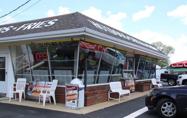
Property Record
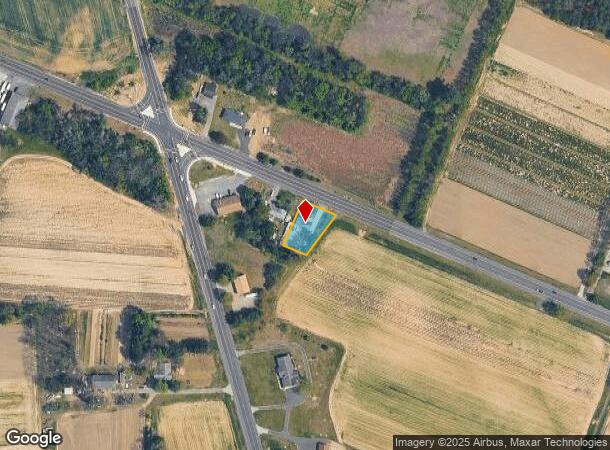
1355 Harding Hwy, Newfield, NJ 08344

NEARBY LISTINGS FOR SALE OR LEASE
Property Detail
1355 Harding Hwy
Philadelphia-Camden-Wilmington, PA-NJ-DE-MD
Gloucester
05-07102-0000-00003
New Jersey
Sfr
0.39 AC
X
Gloucester County
34001C0090F
Philadelphia
1,107 SF
DEMOGRAPHICS near 1355 Harding Hwy
1 Mile
3 Mile
5 Mile
2024 Total Population
873
10,520
39,444
2029 Population
898
10,633
39,246
Pop Growth 2024-2029
+ 2.86%
+ 1.07%
(0.50%)
Average Age
42
42
41
2024 Total Households
320
3,980
14,583
HH Growth 2024-2029
+ 2.81%
+ 0.90%
(0.64%)
Median Household Inc
$109,558
$79,181
$67,927
Avg Household Size
2.70
2.60
2.60
2024 Avg HH Vehicles
2.00
2.00
2.00
Median Home Value
$231,944
$222,425
$202,898
Median Year Built
1975
1974
1969
Nearby Places
Map Layers
Map Styles
 Street
 Aerial
- Restaurants
- Banks
- Shops
- Fitness
- Groceries
PUBLIC TRANSPORTATION
AIRPORT
Atlantic City International
DRIVE
WALK
Distance
Atlantic City International
61 min
28.7 mi
Philadelphia International
DRIVE
WALK
Distance
Philadelphia International
57 min
35.8 mi
Freight Ports
Broadway Terminal - Pier 5
DRIVE
WALK
Distance
Broadway Terminal - Pier 5
41 min
27.3 mi
SALE & LEASE HISTORY
LISTING DATE
SALE/LEASE

May 23, 2019
For Sale
Nearby Properties
Address
Land Use
TOTAL SIZE
Lot Size
Zoning
Address
Land Use
TOTAL SIZE
Lot Size
Zoning
44.19 AC
PIRA
Address
Land Use
TOTAL SIZE
Lot Size
Zoning
4,936 SF
35.45 AC
RA
Address
Land Use
TOTAL SIZE
Lot Size
Zoning
48.65 AC
I2
Address
Land Use
TOTAL SIZE
Lot Size
Zoning
22.29 AC
A
Address
Land Use
TOTAL SIZE
Lot Size
Zoning
10.33 AC
RA
Address
Land Use
TOTAL SIZE
Lot Size
Zoning
1,358 SF
9.10 AC
RA
Address
Land Use
TOTAL SIZE
Lot Size
Zoning
2.44 AC
I2
Address
Land Use
TOTAL SIZE
Lot Size
Zoning
6.37 AC
RA
Address
Land Use
TOTAL SIZE
Lot Size
Zoning
Address
Land Use
TOTAL SIZE
Lot Size
Zoning
13.12 AC
I
Address
Land Use
TOTAL SIZE
Lot Size
Zoning
12 AC
PAP
Address
Land Use
TOTAL SIZE
Lot Size
Zoning
1,344 SF
49.22 AC
LM
Address
Land Use
TOTAL SIZE
Lot Size
Zoning
4 AC
C
Address
Land Use
TOTAL SIZE
Lot Size
Zoning
3,060 SF
6 AC
PAP
Address
Land Use
TOTAL SIZE
Lot Size
Zoning
13.20 AC
A
Address
Land Use
TOTAL SIZE
Lot Size
Zoning
1.95 AC
Address
Land Use
TOTAL SIZE
Lot Size
Zoning
7.36 AC
RA
Address
Land Use
TOTAL SIZE
Lot Size
Zoning
1.88 AC
I2
Address
Land Use
TOTAL SIZE
Lot Size
Zoning
15.63 AC
A
Address
Land Use
TOTAL SIZE
Lot Size
Zoning
54.66 AC
MH
Address
Land Use
TOTAL SIZE
Lot Size
Zoning
2,496 SF
2.56 AC
01
Address
Land Use
TOTAL SIZE
Lot Size
Zoning
1,590 SF
1.89 AC
HC
Address
Land Use
TOTAL SIZE
Lot Size
Zoning
Address
Land Use
TOTAL SIZE
Lot Size
Zoning
3.80 AC
R4
Address
Land Use
TOTAL SIZE
Lot Size
Zoning
1.92 AC
C
Address
Land Use
TOTAL SIZE
Lot Size
Zoning
0.60 AC
R2
Address
Land Use
TOTAL SIZE
Lot Size
Zoning
9.17 AC
HC
Address
Land Use
TOTAL SIZE
Lot Size
Zoning
2.42 AC
RA
Address
Land Use
TOTAL SIZE
Lot Size
Zoning
24.30 AC
LM
Address
Land Use
TOTAL SIZE
Lot Size
Zoning
3,070 SF
1.09 AC
R5H
The World's #1 Commercial Real Estate Marketplace
Connect with us
© 2025 CoStar Group
The information above has been obtained from sources believed reliable. While we do not doubt its accuracy we have not verified it and make no guarantee, warranty or representation about it. It is your responsibility to independently confirm its accuracy and completeness. Any projections, opinions, assumptions, or estimates used are for example only and do not represent the current or future performance of the property. The value of this transaction to you depends on tax and other factors which should be evaluated by your tax, financial, and legal advisors. You and your advisors should conduct a careful, independent investigation of the property to determine to your satisfaction the suitability of the property for your needs.