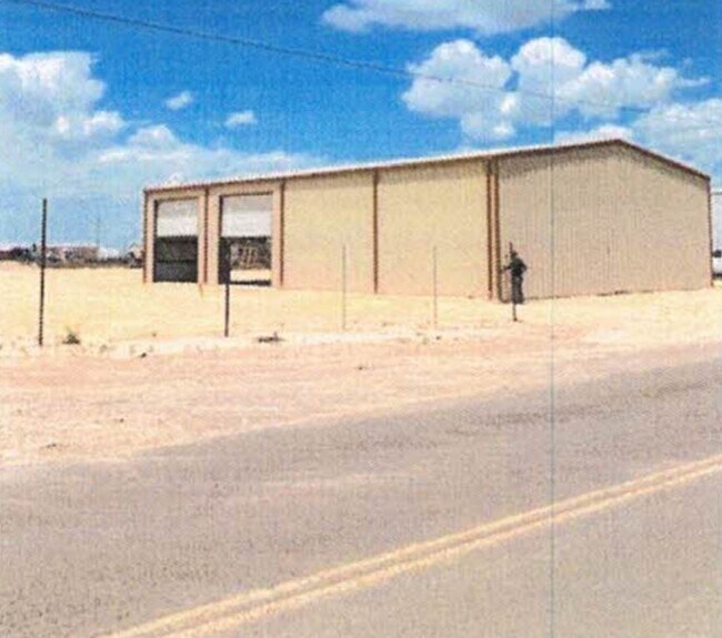
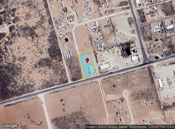
Property Record
13550 W 42Nd St, Odessa, TX 79764
NEARBY LISTINGS FOR SALE OR LEASE
Property Detail
13550 W 42Nd St
Odessa, TX
Wacasey
33275-00130-00000
WACASEY BLOCK 1 LOT 13
Commercialnec
Ector
X
Texas
48135C0310E
13
2025
1 AC
2025
Midland & Odessa
002701
Other Market Areas
4,000 SF
DEMOGRAPHICS near 13550 W 42Nd St
1 Mile
3 Mile
5 Mile
2024 Total Population
1,823
11,254
24,905
2029 Population
1,829
11,091
24,126
Pop Growth 2024-2029
+ 0.33%
(1.45%)
(3.13%)
Average Age
31
32
32
2024 Total Households
524
3,415
7,708
HH Growth 2024-2029
(0.19%)
(2.05%)
(3.63%)
Median Household Inc
$32,500
$65,118
$53,299
Avg Household Size
3.30
3.20
3.10
2024 Avg HH Vehicles
3.00
3.00
2.00
Median Home Value
$92,477
$151,632
$116,916
Median Year Built
1990
1989
1986
Nearby Places
Map Layers
Map Styles
 Street
 Aerial
- Restaurants
- Banks
- Shops
- Fitness
- Groceries
PUBLIC TRANSPORTATION
AIRPORT
Midland International Air And Space Port
DRIVE
WALK
Distance
Midland International Air And Space Port
35 min
23.3 mi
Freight Ports
Port of Corpus Christi
DRIVE
WALK
Distance
Port of Corpus Christi
514 min
494.3 mi
SALE & LEASE HISTORY
LISTING DATE
SALE/LEASE

Jun 08, 2023
For Lease
Jul 19, 2022
For Lease
Aug 26, 2020
For Sale
Nearby Properties
Address
Land Use
TOTAL SIZE
Lot Size
Zoning
Address
Land Use
TOTAL SIZE
Lot Size
Zoning
106,812 SF
28 AC
EW5
Address
Land Use
TOTAL SIZE
Lot Size
Zoning
67,689 SF
9.55 AC
EW4
Address
Land Use
TOTAL SIZE
Lot Size
Zoning
1,250 SF
36.72 AC
EW6
Address
Land Use
TOTAL SIZE
Lot Size
Zoning
19,500 SF
10 AC
EW7
Address
Land Use
TOTAL SIZE
Lot Size
Zoning
4,920 SF
80 AC
EW6
Address
Land Use
TOTAL SIZE
Lot Size
Zoning
10,500 SF
1.30 AC
EW4
Address
Land Use
TOTAL SIZE
Lot Size
Zoning
9,940 SF
1.18 AC
EW4
Address
Land Use
TOTAL SIZE
Lot Size
Zoning
9,572 SF
1.23 AC
EW4
Address
Land Use
TOTAL SIZE
Lot Size
Zoning
2,400 SF
35.79 AC
EW6
Address
Land Use
TOTAL SIZE
Lot Size
Zoning
6,470 SF
3.31 AC
EW5
Address
Land Use
TOTAL SIZE
Lot Size
Zoning
8,112 SF
0.88 AC
EW4
Address
Land Use
TOTAL SIZE
Lot Size
Zoning
6,500 SF
5 AC
EW4
Address
Land Use
TOTAL SIZE
Lot Size
Zoning
6,728 SF
1.33 AC
EW4
Address
Land Use
TOTAL SIZE
Lot Size
Zoning
6,876 SF
4.64 AC
EW4
Address
Land Use
TOTAL SIZE
Lot Size
Zoning
2,976 SF
17.10 AC
EW6
Address
Land Use
TOTAL SIZE
Lot Size
Zoning
2,400 SF
8.63 AC
EW7
Address
Land Use
TOTAL SIZE
Lot Size
Zoning
12,400 SF
9.69 AC
EW4
Address
Land Use
TOTAL SIZE
Lot Size
Zoning
6,600 SF
7.44 AC
EW4
Address
Land Use
TOTAL SIZE
Lot Size
Zoning
3,125 SF
10 AC
EW6
Address
Land Use
TOTAL SIZE
Lot Size
Zoning
2,000 SF
2.50 AC
EW7
Address
Land Use
TOTAL SIZE
Lot Size
Zoning
14,869 SF
0.97 AC
EW4
Address
Land Use
TOTAL SIZE
Lot Size
Zoning
6,500 SF
14.68 AC
EW7
Address
Land Use
TOTAL SIZE
Lot Size
Zoning
5,400 SF
8.99 AC
EW6
Address
Land Use
TOTAL SIZE
Lot Size
Zoning
2,460 SF
5.23 AC
EW4
Address
Land Use
TOTAL SIZE
Lot Size
Zoning
8,000 SF
1.15 AC
EW5
Address
Land Use
TOTAL SIZE
Lot Size
Zoning
7,600 SF
10 AC
EW7
Address
Land Use
TOTAL SIZE
Lot Size
Zoning
12,000 SF
31.41 AC
EW6
Address
Land Use
TOTAL SIZE
Lot Size
Zoning
4,800 SF
0.96 AC
EW6
Address
Land Use
TOTAL SIZE
Lot Size
Zoning
12,436 SF
1 AC
EW4
Address
Land Use
TOTAL SIZE
Lot Size
Zoning
9,264 SF
2.19 AC
EW7
The World's #1 Commercial Real Estate Marketplace
Connect with us
© 2026 CoStar Group
The information above has been obtained from sources believed reliable. While we do not doubt its accuracy we have not verified it and make no guarantee, warranty or representation about it. It is your responsibility to independently confirm its accuracy and completeness. Any projections, opinions, assumptions, or estimates used are for example only and do not represent the current or future performance of the property. The value of this transaction to you depends on tax and other factors which should be evaluated by your tax, financial, and legal advisors. You and your advisors should conduct a careful, independent investigation of the property to determine to your satisfaction the suitability of the property for your needs.