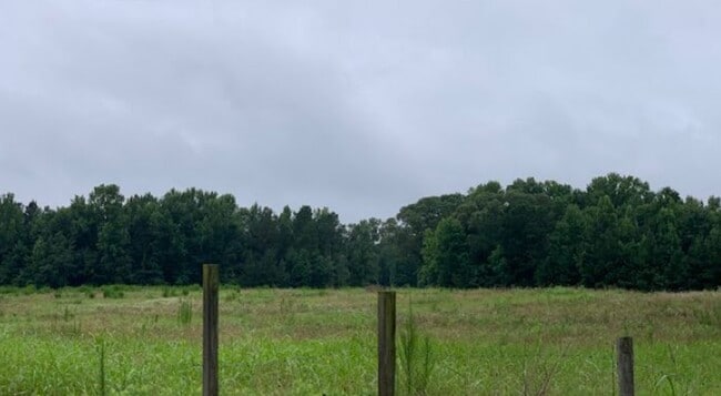
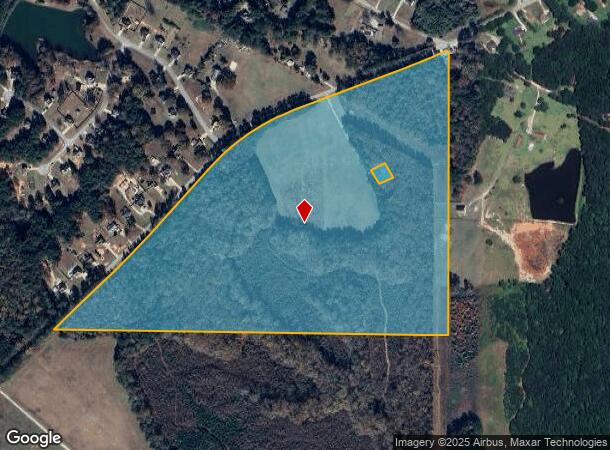
Property Record
13550 Woolsey Rd, Hampton, GA 30228
NEARBY LISTINGS FOR SALE OR LEASE
Property Detail
13550 Woolsey Rd
05-00015-016-001
Clayton
Institutionalgeneral
Georgia
X
59.77 AC
13063C0165F
South Clayton/Henry Cnty
0
Atlanta
2024
Atlanta-Sandy Springs-Roswell, GA
070503
DEMOGRAPHICS near 13550 Woolsey Rd
1 Mile
3 Mile
5 Mile
2024 Total Population
624
6,509
47,894
2029 Population
613
6,653
50,001
Pop Growth 2024-2029
(1.76%)
+ 2.21%
+ 4.40%
Average Age
42
40
38
2024 Total Households
216
2,173
16,136
HH Growth 2024-2029
(1.85%)
+ 2.21%
+ 4.33%
Median Household Inc
$117,856
$99,256
$72,929
Avg Household Size
2.90
2.90
2.90
2024 Avg HH Vehicles
3.00
2.00
2.00
Median Home Value
$257,241
$250,039
$224,314
Median Year Built
2003
2000
2000
Nearby Places
Map Layers
Map Styles
 Street
 Aerial
- Restaurants
- Banks
- Shops
- Fitness
- Groceries
PUBLIC TRANSPORTATION
AIRPORT
Hartsfield - Jackson Atlanta International
DRIVE
WALK
Distance
Hartsfield - Jackson Atlanta International
35 min
22.0 mi
Freight Ports
Georgia Ports - Savannah
DRIVE
WALK
Distance
Georgia Ports - Savannah
261 min
231.2 mi
SALE & LEASE HISTORY
LISTING DATE
SALE/LEASE

Jul 28, 2021
For Sale
Nearby Properties
Address
Land Use
TOTAL SIZE
Lot Size
Zoning
Address
Land Use
TOTAL SIZE
Lot Size
Zoning
1,424,654 SF
172.86 AC
Address
Land Use
TOTAL SIZE
Lot Size
Zoning
39,373 SF
587.19 AC
M1
Address
Land Use
TOTAL SIZE
Lot Size
Zoning
640,693 SF
691.83 AC
PD
Address
Land Use
TOTAL SIZE
Lot Size
Zoning
85,000 SF
16.50 AC
PUD
Address
Land Use
TOTAL SIZE
Lot Size
Zoning
1,826 SF
486.41 AC
AG
Address
Land Use
TOTAL SIZE
Lot Size
Zoning
96.63 AC
PD
Address
Land Use
TOTAL SIZE
Lot Size
Zoning
11,312 SF
560 AC
RA
Address
Land Use
TOTAL SIZE
Lot Size
Zoning
24,966 SF
336.09 AC
AG
Address
Land Use
TOTAL SIZE
Lot Size
Zoning
14,960 SF
325.18 AC
AG
Address
Land Use
TOTAL SIZE
Lot Size
Zoning
87,276 SF
5 AC
M1
Address
Land Use
TOTAL SIZE
Lot Size
Zoning
28,144 SF
22.16 AC
AG
Address
Land Use
TOTAL SIZE
Lot Size
Zoning
68,010 SF
8 AC
M1
Address
Land Use
TOTAL SIZE
Lot Size
Zoning
274.66 AC
ER
Address
Land Use
TOTAL SIZE
Lot Size
Zoning
15,968 SF
2.96 AC
C2
Address
Land Use
TOTAL SIZE
Lot Size
Zoning
231.80 AC
AG
Address
Land Use
TOTAL SIZE
Lot Size
Zoning
8,800 SF
4.19 AC
M1
Address
Land Use
TOTAL SIZE
Lot Size
Zoning
179.10 AC
RS110
Address
Land Use
TOTAL SIZE
Lot Size
Zoning
15,805 SF
1.64 AC
C3
Address
Land Use
TOTAL SIZE
Lot Size
Zoning
395 SF
302.10 AC
AG
Address
Land Use
TOTAL SIZE
Lot Size
Zoning
Address
Land Use
TOTAL SIZE
Lot Size
Zoning
38,968 SF
1.15 AC
M1
Address
Land Use
TOTAL SIZE
Lot Size
Zoning
10,800 SF
5.75 AC
M1
Address
Land Use
TOTAL SIZE
Lot Size
Zoning
305.48 AC
AG
Address
Land Use
TOTAL SIZE
Lot Size
Zoning
101.72 AC
AG
The World's #1 Commercial Real Estate Marketplace
Connect with us
© 2025 CoStar Group
The information above has been obtained from sources believed reliable. While we do not doubt its accuracy we have not verified it and make no guarantee, warranty or representation about it. It is your responsibility to independently confirm its accuracy and completeness. Any projections, opinions, assumptions, or estimates used are for example only and do not represent the current or future performance of the property. The value of this transaction to you depends on tax and other factors which should be evaluated by your tax, financial, and legal advisors. You and your advisors should conduct a careful, independent investigation of the property to determine to your satisfaction the suitability of the property for your needs.