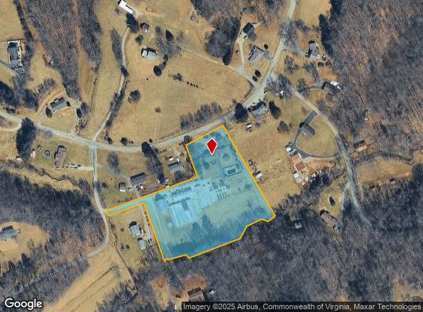
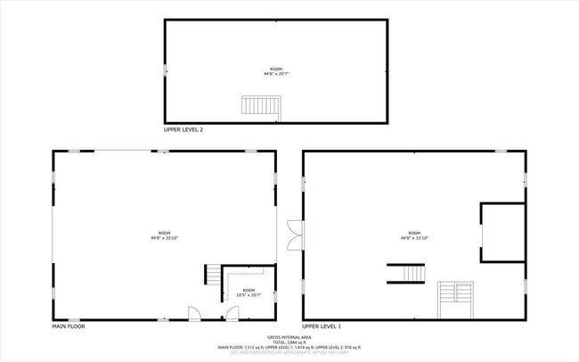
Property Record
1356 Coopers Cove Rd, Hardy, VA 24101
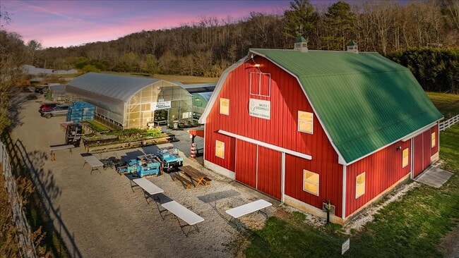
This Property Is For Sale
NEARBY LISTINGS FOR SALE OR LEASE
-
-
View all Hardy listings for sale on LoopNet.com
Property Detail
1356 Coopers Cove Rd
Roanoke, VA
Cornerstone Land Surveying
0060004500
Franklin
Sfr
Virginia
X
5.15 AC
51019C0405D
North Franklin County
1,906 SF
Roanoke
DEMOGRAPHICS near 1356 Coopers Cove Rd
1 Mile
3 Mile
5 Mile
2024 Total Population
332
3,342
22,832
2029 Population
332
3,367
22,724
Pop Growth 2024-2029
0.00%
+ 0.75%
(0.47%)
Average Age
45
45
43
2024 Total Households
134
1,372
9,623
HH Growth 2024-2029
0.00%
+ 0.51%
(0.57%)
Median Household Inc
$71,785
$72,056
$56,131
Avg Household Size
2.50
2.40
2.30
2024 Avg HH Vehicles
3.00
2.00
2.00
Median Home Value
$198,957
$217,295
$188,198
Median Year Built
1981
1978
1973
Nearby Places
Map Layers
Map Styles
 Street
 Aerial
- Restaurants
- Banks
- Shops
- Fitness
- Groceries
PUBLIC TRANSPORTATION
COMMUTER RAIL
Roanoke (Northeast Regional - Amtrak)
DRIVE
WALK
Distance
Roanoke (Northeast Regional - Amtrak)
15 min
8.1 mi
AIRPORT
Roanoke/Blacksburg Regional (Woodrum Field)
DRIVE
WALK
Distance
Roanoke/Blacksburg Regional (Woodrum Field)
24 min
13.1 mi
Freight Ports
Virginia Port Authority - Richmond
DRIVE
WALK
Distance
Virginia Port Authority - Richmond
230 min
168.4 mi
Nearby Properties
Address
Land Use
TOTAL SIZE
Lot Size
Zoning
Address
Land Use
TOTAL SIZE
Lot Size
Zoning
48,908 SF
30.09 AC
A1
Address
Land Use
TOTAL SIZE
Lot Size
Zoning
122.08 AC
A1
Address
Land Use
TOTAL SIZE
Lot Size
Zoning
94.31 AC
PRD
Address
Land Use
TOTAL SIZE
Lot Size
Zoning
258.07 AC
AG1
Address
Land Use
TOTAL SIZE
Lot Size
Zoning
3,968 SF
2.50 AC
R3
Address
Land Use
TOTAL SIZE
Lot Size
Zoning
7,451 SF
3.60 AC
AG1
Address
Land Use
TOTAL SIZE
Lot Size
Zoning
6,332 SF
1 AC
A1
Address
Land Use
TOTAL SIZE
Lot Size
Zoning
11,640 SF
33.12 AC
I2
Address
Land Use
TOTAL SIZE
Lot Size
Zoning
286.14 AC
A1
Address
Land Use
TOTAL SIZE
Lot Size
Zoning
6,000 SF
1.99 AC
PRD
Address
Land Use
TOTAL SIZE
Lot Size
Zoning
20.21 AC
A1
Address
Land Use
TOTAL SIZE
Lot Size
Zoning
3,647 SF
0.87 AC
AR
Address
Land Use
TOTAL SIZE
Lot Size
Zoning
2,622 SF
0.89 AC
AR
Address
Land Use
TOTAL SIZE
Lot Size
Zoning
3,880 SF
0.63 AC
B2
Address
Land Use
TOTAL SIZE
Lot Size
Zoning
0.20 AC
Address
Land Use
TOTAL SIZE
Lot Size
Zoning
5,280 SF
61.60 AC
I2
Address
Land Use
TOTAL SIZE
Lot Size
Zoning
156 AC
A1
Address
Land Use
TOTAL SIZE
Lot Size
Zoning
4,800 SF
Address
Land Use
TOTAL SIZE
Lot Size
Zoning
78.32 AC
AG3
Address
Land Use
TOTAL SIZE
Lot Size
Zoning
163.33 AC
A1
Address
Land Use
TOTAL SIZE
Lot Size
Zoning
58.73 AC
AG3
Address
Land Use
TOTAL SIZE
Lot Size
Zoning
2,420 SF
2.80 AC
R1
Address
Land Use
TOTAL SIZE
Lot Size
Zoning
59.91 AC
A1
Address
Land Use
TOTAL SIZE
Lot Size
Zoning
113.62 AC
A1
Address
Land Use
TOTAL SIZE
Lot Size
Zoning
3,680 SF
0.98 AC
R1
Address
Land Use
TOTAL SIZE
Lot Size
Zoning
5,768 SF
10.56 AC
B2
Address
Land Use
TOTAL SIZE
Lot Size
Zoning
36.10 AC
AG1
Address
Land Use
TOTAL SIZE
Lot Size
Zoning
16.05 AC
AG3
Address
Land Use
TOTAL SIZE
Lot Size
Zoning
1,610 SF
3.05 AC
AG1
Address
Land Use
TOTAL SIZE
Lot Size
Zoning
98 AC
A1
The World's #1 Commercial Real Estate Marketplace
Connect with us
© 2025 CoStar Group
The information above has been obtained from sources believed reliable. While we do not doubt its accuracy we have not verified it and make no guarantee, warranty or representation about it. It is your responsibility to independently confirm its accuracy and completeness. Any projections, opinions, assumptions, or estimates used are for example only and do not represent the current or future performance of the property. The value of this transaction to you depends on tax and other factors which should be evaluated by your tax, financial, and legal advisors. You and your advisors should conduct a careful, independent investigation of the property to determine to your satisfaction the suitability of the property for your needs.