Property Record
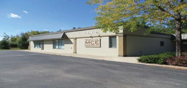
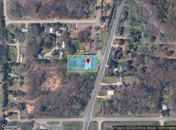
13560 76Th St, South Haven, MI 49090

NEARBY LISTINGS FOR SALE OR LEASE
-
-
View all South Haven listings for lease on LoopNet.com
Property Detail
13560 76Th St
80-17-021-007-00
281-D 21-1-17 774-139 1104-49 1422-330 1472-531 1500-776 BEG ON E SEC L 652.5 FT N OF E 1/4 POST OF SEC, TH W PAR WITH E & W
Officebuilding
Van Buren
X
Michigan
26159C0131D
1.04 AC
2024
Van Buren County
2025
West Michigan
010500
Kalamazoo-Portage, MI
4,592 SF
DEMOGRAPHICS near 13560 76Th St
1 Mile
3 Mile
5 Mile
2024 Total Population
1,032
8,549
13,489
2029 Population
1,070
8,859
13,981
Pop Growth 2024-2029
+ 3.68%
+ 3.63%
+ 3.65%
Average Age
45
46
46
2024 Total Households
447
3,880
5,991
HH Growth 2024-2029
+ 3.58%
+ 3.97%
+ 4.11%
Median Household Inc
$62,830
$50,906
$51,419
Avg Household Size
2.20
2.10
2.20
2024 Avg HH Vehicles
2.00
2.00
2.00
Median Home Value
$293,809
$274,787
$264,535
Median Year Built
1973
1969
1973
Nearby Places
Map Layers
Map Styles
 Street
 Aerial
- Restaurants
- Banks
- Shops
- Fitness
- Groceries
SALE & LEASE HISTORY
LISTING DATE
SALE/LEASE

May 31, 2019
For Lease
Nearby Properties
Address
Land Use
TOTAL SIZE
Lot Size
Zoning
Address
Land Use
TOTAL SIZE
Lot Size
Zoning
3,000 AC
Address
Land Use
TOTAL SIZE
Lot Size
Zoning
190,640 SF
12.53 AC
Address
Land Use
TOTAL SIZE
Lot Size
Zoning
1,720 AC
Address
Land Use
TOTAL SIZE
Lot Size
Zoning
1,428 SF
5.80 AC
HIGH DENSE
Address
Land Use
TOTAL SIZE
Lot Size
Zoning
121,966 SF
19.66 AC
I-2
Address
Land Use
TOTAL SIZE
Lot Size
Zoning
26,272 SF
Address
Land Use
TOTAL SIZE
Lot Size
Zoning
152,748 SF
16.10 AC
I-1
Address
Land Use
TOTAL SIZE
Lot Size
Zoning
38,967 SF
3.90 AC
RM-1
Address
Land Use
TOTAL SIZE
Lot Size
Zoning
4,194 SF
0.53 AC
B-3
Address
Land Use
TOTAL SIZE
Lot Size
Zoning
32,268 SF
2.62 AC
R-2
Address
Land Use
TOTAL SIZE
Lot Size
Zoning
8,340 SF
12.53 AC
Address
Land Use
TOTAL SIZE
Lot Size
Zoning
37,152 SF
5.25 AC
Address
Land Use
TOTAL SIZE
Lot Size
Zoning
2,640 SF
7.80 AC
B-4
Address
Land Use
TOTAL SIZE
Lot Size
Zoning
36,800 SF
2.20 AC
B-3
Address
Land Use
TOTAL SIZE
Lot Size
Zoning
19,602 SF
0.23 AC
CBD
Address
Land Use
TOTAL SIZE
Lot Size
Zoning
32,040 SF
1.60 AC
PUD
Address
Land Use
TOTAL SIZE
Lot Size
Zoning
43,920 SF
5.63 AC
RM-1
Address
Land Use
TOTAL SIZE
Lot Size
Zoning
6,705 SF
0.37 AC
RM-1
Address
Land Use
TOTAL SIZE
Lot Size
Zoning
14.14 AC
RM-1
Address
Land Use
TOTAL SIZE
Lot Size
Zoning
20,144 SF
86,684 AC
B-3
Address
Land Use
TOTAL SIZE
Lot Size
Zoning
65,786 SF
5.27 AC
I-1
Address
Land Use
TOTAL SIZE
Lot Size
Zoning
47,389 SF
4.06 AC
B-4
Address
Land Use
TOTAL SIZE
Lot Size
Zoning
40,950 SF
3.53 AC
RM-1
Address
Land Use
TOTAL SIZE
Lot Size
Zoning
19,534 SF
3.80 AC
Address
Land Use
TOTAL SIZE
Lot Size
Zoning
25,149 SF
5.30 AC
HIGH DENSE
Address
Land Use
TOTAL SIZE
Lot Size
Zoning
7,164 SF
2.73 AC
Address
Land Use
TOTAL SIZE
Lot Size
Zoning
34.85 AC
I
Address
Land Use
TOTAL SIZE
Lot Size
Zoning
0.43 AC
Address
Land Use
TOTAL SIZE
Lot Size
Zoning
3,464 SF
0.06 AC
B-3
Address
Land Use
TOTAL SIZE
Lot Size
Zoning
125,240 SF
10.36 AC
I-1
The World's #1 Commercial Real Estate Marketplace
Connect with us
© 2026 CoStar Group
The information above has been obtained from sources believed reliable. While we do not doubt its accuracy we have not verified it and make no guarantee, warranty or representation about it. It is your responsibility to independently confirm its accuracy and completeness. Any projections, opinions, assumptions, or estimates used are for example only and do not represent the current or future performance of the property. The value of this transaction to you depends on tax and other factors which should be evaluated by your tax, financial, and legal advisors. You and your advisors should conduct a careful, independent investigation of the property to determine to your satisfaction the suitability of the property for your needs.