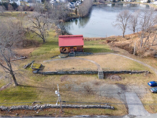
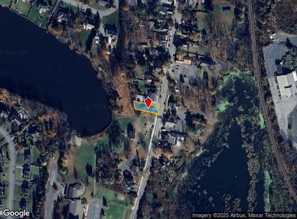
Property Record
1357 Kings Hwy, Chester, NY 10918
NEARBY LISTINGS FOR SALE OR LEASE
Property Detail
1357 Kings Hwy
332289-014-000-0006-013.000-0000
ART GALERRY
Commercialnec
Orange
X
New York
36071C0458E
13.00
2024
0.17 AC
2024
Monroe
014302
Northern New Jersey
3,584 SF
New York-Jersey City-White Plains, NY-NJ
DEMOGRAPHICS near 1357 Kings Hwy
1 Mile
3 Mile
5 Mile
2024 Total Population
1,067
10,051
35,550
2029 Population
1,065
10,138
36,227
Pop Growth 2024-2029
(0.19%)
+ 0.87%
+ 1.90%
Average Age
40
40
41
2024 Total Households
335
3,394
12,233
HH Growth 2024-2029
0.00%
+ 0.97%
+ 1.99%
Median Household Inc
$157,368
$132,066
$126,321
Avg Household Size
3.00
2.80
2.80
2024 Avg HH Vehicles
3.00
2.00
2.00
Median Home Value
$449,603
$371,874
$372,251
Median Year Built
1992
1981
1978
Nearby Places
- Restaurants
- Banks
- Shops
- Fitness
- Groceries
PUBLIC TRANSPORTATION
AIRPORT
New York Stewart International
DRIVE
WALK
Distance
New York Stewart International
35 min
18.8 mi
Freight Ports
Port Newark Container Terminal
DRIVE
WALK
Distance
Port Newark Container Terminal
84 min
62.6 mi
SALE & LEASE HISTORY
LISTING DATE
SALE/LEASE

Aug 31, 2023
For Sale
Nearby Properties
Address
Land Use
TOTAL SIZE
Lot Size
Zoning
Address
Land Use
TOTAL SIZE
Lot Size
Zoning
878,010 SF
50.40 AC
Address
Land Use
TOTAL SIZE
Lot Size
Zoning
198,260 SF
27.60 AC
B2
Address
Land Use
TOTAL SIZE
Lot Size
Zoning
50.30 AC
I
Address
Land Use
TOTAL SIZE
Lot Size
Zoning
404,550 SF
35.90 AC
M1
Address
Land Use
TOTAL SIZE
Lot Size
Zoning
319,144 SF
47.80 AC
IP
Address
Land Use
TOTAL SIZE
Lot Size
Zoning
116,426 SF
9.10 AC
M1
Address
Land Use
TOTAL SIZE
Lot Size
Zoning
211,990 SF
13.10 AC
M1
Address
Land Use
TOTAL SIZE
Lot Size
Zoning
12.80 AC
AR3
Address
Land Use
TOTAL SIZE
Lot Size
Zoning
194,400 SF
28.10 AC
I
Address
Land Use
TOTAL SIZE
Lot Size
Zoning
92,969 SF
4.98 AC
M1
Address
Land Use
TOTAL SIZE
Lot Size
Zoning
103,055 SF
145.60 AC
AR3*
Address
Land Use
TOTAL SIZE
Lot Size
Zoning
5 AC
IP
Address
Land Use
TOTAL SIZE
Lot Size
Zoning
52,575 SF
64.60 AC
AR3*
Address
Land Use
TOTAL SIZE
Lot Size
Zoning
71,910 SF
10.80 AC
Address
Land Use
TOTAL SIZE
Lot Size
Zoning
61,975 SF
10.80 AC
M1
Address
Land Use
TOTAL SIZE
Lot Size
Zoning
159,063 SF
18.80 AC
M1
Address
Land Use
TOTAL SIZE
Lot Size
Zoning
19,440 SF
6.80 AC
RM
Address
Land Use
TOTAL SIZE
Lot Size
Zoning
101,476 SF
6.30 AC
M1
Address
Land Use
TOTAL SIZE
Lot Size
Zoning
43,664 SF
3.10 AC
B2
Address
Land Use
TOTAL SIZE
Lot Size
Zoning
43,738 SF
16.90 AC
GC
Address
Land Use
TOTAL SIZE
Lot Size
Zoning
88,440 SF
4.50 AC
M1
Address
Land Use
TOTAL SIZE
Lot Size
Zoning
63,068 SF
10.80 AC
M1
Address
Land Use
TOTAL SIZE
Lot Size
Zoning
43,952 SF
14.10 AC
B2
Address
Land Use
TOTAL SIZE
Lot Size
Zoning
18.30 AC
AR3*
Address
Land Use
TOTAL SIZE
Lot Size
Zoning
72,430 SF
5.60 AC
M2
Address
Land Use
TOTAL SIZE
Lot Size
Zoning
7 AC
IP
Address
Land Use
TOTAL SIZE
Lot Size
Zoning
103,355 SF
4.98 AC
M1
Address
Land Use
TOTAL SIZE
Lot Size
Zoning
67,605 SF
5.40 AC
M1
Address
Land Use
TOTAL SIZE
Lot Size
Zoning
35,445 SF
34.10 AC
AR3
Address
Land Use
TOTAL SIZE
Lot Size
Zoning
65,130 SF
5 AC
IP
The World's #1 Commercial Real Estate Marketplace
Connect with us
© 2025 CoStar Group
The information above has been obtained from sources believed reliable. While we do not doubt its accuracy we have not verified it and make no guarantee, warranty or representation about it. It is your responsibility to independently confirm its accuracy and completeness. Any projections, opinions, assumptions, or estimates used are for example only and do not represent the current or future performance of the property. The value of this transaction to you depends on tax and other factors which should be evaluated by your tax, financial, and legal advisors. You and your advisors should conduct a careful, independent investigation of the property to determine to your satisfaction the suitability of the property for your needs.