Property Record
1357 Richmond Rd, Charlottesville, VA 22911
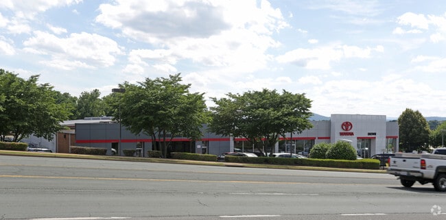
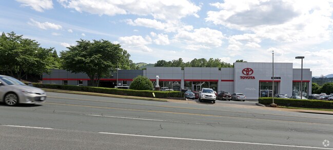
Property Detail
1357 Richmond Rd
07800-00-00-014C0
ACREAGE BROWN HONDA
Realpropertynec
Albemarle
HIGHWAY CO
Virginia
B and X Area of moderate flood hazard, usually the area between the limits of the 100-year and 500-year floods.
0.47 AC
2025
Charlottesville
2025
Other Market Areas
010502
Charlottesville, VA
907 SF
NEARBY LISTINGS FOR SALE OR LEASE
DEMOGRAPHICS near 1357 Richmond Rd
1 mile
3 mile
5 mile
2025 Total Population
7,623
46,238
101,373
2030 Population
7,776
46,123
102,504
Pop Growth 2025-2030
+ 2.01%
(0.25%)
+ 1.12%
Average Age
44
38
38
2025 Total Households
3,715
20,300
41,207
HH Growth 2025-2030
+ 2.23%
(0.12%)
+ 1.22%
Median Household Inc
$98,277
$87,255
$79,949
Avg Household Size
2.00
2.20
2.20
2025 Avg HH Vehicles
2.00
2.00
2.00
Median Home Value
$458,684
$493,437
$473,792
Median Year Built
1998
1983
1985
Nearby Places
Map Layers
Map Styles
 Street
 Aerial
Layers
 Traffic
 Biking
Places
Listings with unknown addresses are not visible on the map
- Restaurants
- Banks
- Shops
- Fitness
- Groceries
PUBLIC TRANSPORTATION
COMMUTER RAIL
Drive
Walk
Distance
9 min
2.8 mi
AIRPORT
Charlottesville-Albemarle
Drive
Walk
Distance
Charlottesville-Albemarle
22 min
10.5 mi
Nearby Properties
Address
Land Use
TOTAL SIZE
Lot Size
Zoning
Address
Land Use
TOTAL SIZE
Lot Size
Zoning
872,960 SF
20.90 AC
CM
Address
Land Use
TOTAL SIZE
Lot Size
Zoning
429,500 SF
38.49 AC
PDMC
Address
Land Use
TOTAL SIZE
Lot Size
Zoning
15 AC
RURAL AREA
Address
Land Use
TOTAL SIZE
Lot Size
Zoning
167,708 SF
1.05 AC
CM
Address
Land Use
TOTAL SIZE
Lot Size
Zoning
3,465 SF
145.17 AC
CV
Address
Land Use
TOTAL SIZE
Lot Size
Zoning
160,621 SF
55.78 AC
PLANNED RE
Address
Land Use
TOTAL SIZE
Lot Size
Zoning
101,778 SF
11.11 AC
CM
Address
Land Use
TOTAL SIZE
Lot Size
Zoning
3,803 SF
266.70 AC
CV
Address
Land Use
TOTAL SIZE
Lot Size
Zoning
12,180 SF
26.20 AC
RURAL AREA
Address
Land Use
TOTAL SIZE
Lot Size
Zoning
578,208 SF
2.06 AC
CX-8
Address
Land Use
TOTAL SIZE
Lot Size
Zoning
43,616 SF
2.24 AC
CX-8
Address
Land Use
TOTAL SIZE
Lot Size
Zoning
983 SF
0.39 AC
CM
Address
Land Use
TOTAL SIZE
Lot Size
Zoning
10,270 SF
3.59 AC
RX-5
Address
Land Use
TOTAL SIZE
Lot Size
Zoning
393,960 SF
16.14 AC
NMD
Address
Land Use
TOTAL SIZE
Lot Size
Zoning
30,896 SF
0.97 AC
DX
Address
Land Use
TOTAL SIZE
Lot Size
Zoning
240,936 SF
1.26 AC
NX-10
Address
Land Use
TOTAL SIZE
Lot Size
Zoning
14,000 SF
6.45 AC
CX-5
Address
Land Use
TOTAL SIZE
Lot Size
Zoning
336,000 SF
20.20 AC
R15 RESIDE
Address
Land Use
TOTAL SIZE
Lot Size
Zoning
20.41 AC
Address
Land Use
TOTAL SIZE
Lot Size
Zoning
14,025 SF
10.94 AC
RX-5
Address
Land Use
TOTAL SIZE
Lot Size
Zoning
218,660 SF
1.27 AC
CX-8
Address
Land Use
TOTAL SIZE
Lot Size
Zoning
1.38 AC
CX-3
Address
Land Use
TOTAL SIZE
Lot Size
Zoning
222,253 SF
0.73 AC
NX-10
Address
Land Use
TOTAL SIZE
Lot Size
Zoning
110,969 SF
2.06 AC
CM
Address
Land Use
TOTAL SIZE
Lot Size
Zoning
5,136 SF
4.27 AC
RX-5
Address
Land Use
TOTAL SIZE
Lot Size
Zoning
82,308 SF
97.43 AC
R1 RESIDEN
Address
Land Use
TOTAL SIZE
Lot Size
Zoning
249,740 SF
42.40 AC
CM
Address
Land Use
TOTAL SIZE
Lot Size
Zoning
42,336 SF
0.90 AC
CV
Address
Land Use
TOTAL SIZE
Lot Size
Zoning
12,495 SF
4.50 AC
NX-10
Address
Land Use
TOTAL SIZE
Lot Size
Zoning
67,354 SF
18.86 AC
CM
The World's #1 Commercial Real Estate Marketplace
Connect with us
© 2026 CoStar Group
The information above has been obtained from sources believed reliable. While we do not doubt its accuracy we have not verified it and make no guarantee, warranty or representation about it. It is your responsibility to independently confirm its accuracy and completeness. Any projections, opinions, assumptions, or estimates used are for example only and do not represent the current or future performance of the property. The value of this transaction to you depends on tax and other factors which should be evaluated by your tax, financial, and legal advisors. You and your advisors should conduct a careful, independent investigation of the property to determine to your satisfaction the suitability of the property for your needs.