Property Record
1358 Us Highway 60 E, Republic, MO 65738

Property Detail
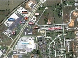
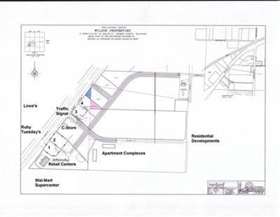
1358 Us Highway 60 E
Springfield, MO
REPUBLIC COMMONS PHASE 1 RPLT LOT 1 & 2 LOT 2
17-16-300-155
GREENE
Carwash
Missouri
INC
1-2
B and X Area of moderate flood hazard, usually the area between the limits of the 100-year and 500-year floods.
1.28 AC
2025
Outlying Greene County
2025
Springfield
004802
NEARBY LISTINGS FOR SALE OR LEASE
DEMOGRAPHICS near 1358 Us Highway 60 E
1 mile
3 mile
5 mile
2025 Total Population
5,101
21,892
28,553
2030 Population
5,209
22,592
29,502
Pop Growth 2025-2030
+ 2.12%
+ 3.20%
+ 3.32%
Average Age
36
37
37
2025 Total Households
1,996
8,235
10,734
HH Growth 2025-2030
+ 2.25%
+ 3.35%
+ 3.46%
Median Household Inc
$63,944
$70,307
$74,074
Avg Household Size
2.60
2.60
2.60
2025 Avg HH Vehicles
2.00
2.00
2.00
Median Home Value
$219,316
$232,381
$237,972
Median Year Built
1992
1994
1995
Nearby Places
Map Layers
Map Styles
 Street
 Aerial
Layers
 Traffic
 Biking
Places
Listings with unknown addresses are not visible on the map
- Restaurants
- Banks
- Shops
- Fitness
- Groceries
PUBLIC TRANSPORTATION
AIRPORT
Springfield-Branson Ntl
Drive
Walk
Distance
Springfield-Branson Ntl
27 min
14.0 mi
Freight Ports
Tulsa Port of Inola
Drive
Walk
Distance
Tulsa Port of Inola
186 min
165.8 mi
SALE & LEASE HISTORY
LISTING DATE
SALE/LEASE

Sep 24, 2016
For Sale
Nearby Properties
Address
Land Use
TOTAL SIZE
Lot Size
Zoning
Address
Land Use
TOTAL SIZE
Lot Size
Zoning
112.47 AC
INC.
Address
Land Use
TOTAL SIZE
Lot Size
Zoning
359,722 SF
117.25 AC
INC
Address
Land Use
TOTAL SIZE
Lot Size
Zoning
Address
Land Use
TOTAL SIZE
Lot Size
Zoning
5.02 AC
Address
Land Use
TOTAL SIZE
Lot Size
Zoning
10.53 AC
INC.
Address
Land Use
TOTAL SIZE
Lot Size
Zoning
157,134 SF
18.35 AC
INC
Address
Land Use
TOTAL SIZE
Lot Size
Zoning
129,624 SF
10.94 AC
INC
Address
Land Use
TOTAL SIZE
Lot Size
Zoning
Address
Land Use
TOTAL SIZE
Lot Size
Zoning
136,508 SF
16.42 AC
INC
Address
Land Use
TOTAL SIZE
Lot Size
Zoning
1,881 SF
3.45 AC
INC
Address
Land Use
TOTAL SIZE
Lot Size
Zoning
12.09 AC
Address
Land Use
TOTAL SIZE
Lot Size
Zoning
43,092 SF
5.51 AC
INC
Address
Land Use
TOTAL SIZE
Lot Size
Zoning
1,315 SF
7.58 AC
Address
Land Use
TOTAL SIZE
Lot Size
Zoning
5.24 AC
Address
Land Use
TOTAL SIZE
Lot Size
Zoning
8.52 AC
INC
Address
Land Use
TOTAL SIZE
Lot Size
Zoning
6.15 AC
INC
Address
Land Use
TOTAL SIZE
Lot Size
Zoning
8.65 AC
INC
Address
Land Use
TOTAL SIZE
Lot Size
Zoning
3.56 AC
INC
Address
Land Use
TOTAL SIZE
Lot Size
Zoning
50,472 SF
4.03 AC
INC
Address
Land Use
TOTAL SIZE
Lot Size
Zoning
7.99 AC
INC
Address
Land Use
TOTAL SIZE
Lot Size
Zoning
7.98 AC
INC
Address
Land Use
TOTAL SIZE
Lot Size
Zoning
80,344 SF
5.31 AC
INC
Address
Land Use
TOTAL SIZE
Lot Size
Zoning
1.94 AC
INC.
Address
Land Use
TOTAL SIZE
Lot Size
Zoning
10,726 SF
1.92 AC
INC
Address
Land Use
TOTAL SIZE
Lot Size
Zoning
2.65 AC
INC
Address
Land Use
TOTAL SIZE
Lot Size
Zoning
9,960 SF
5.09 AC
INC
Address
Land Use
TOTAL SIZE
Lot Size
Zoning
46,775 SF
4.60 AC
INC
Address
Land Use
TOTAL SIZE
Lot Size
Zoning
27,924 SF
2.04 AC
INC
Address
Land Use
TOTAL SIZE
Lot Size
Zoning
76,794 SF
6.46 AC
INC
Address
Land Use
TOTAL SIZE
Lot Size
Zoning
2,400 SF
5.29 AC
INC
The World's #1 Commercial Real Estate Marketplace
Connect with us
© 2026 CoStar Group
The information above has been obtained from sources believed reliable. While we do not doubt its accuracy we have not verified it and make no guarantee, warranty or representation about it. It is your responsibility to independently confirm its accuracy and completeness. Any projections, opinions, assumptions, or estimates used are for example only and do not represent the current or future performance of the property. The value of this transaction to you depends on tax and other factors which should be evaluated by your tax, financial, and legal advisors. You and your advisors should conduct a careful, independent investigation of the property to determine to your satisfaction the suitability of the property for your needs.