Property Record
1359 Hoyt Braswell Rd, Wrens, GA 30833

NEARBY LISTINGS FOR SALE OR LEASE
Property Detail
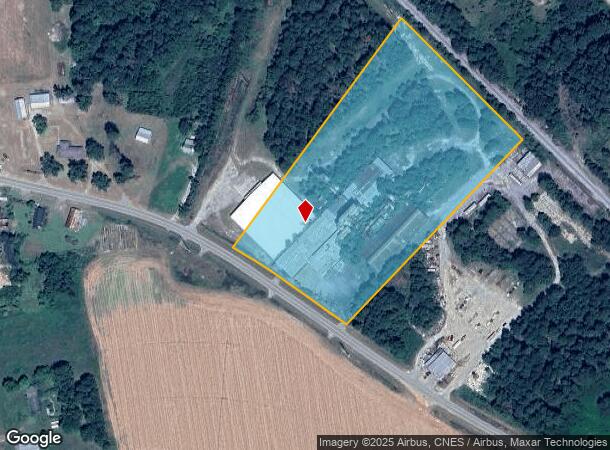
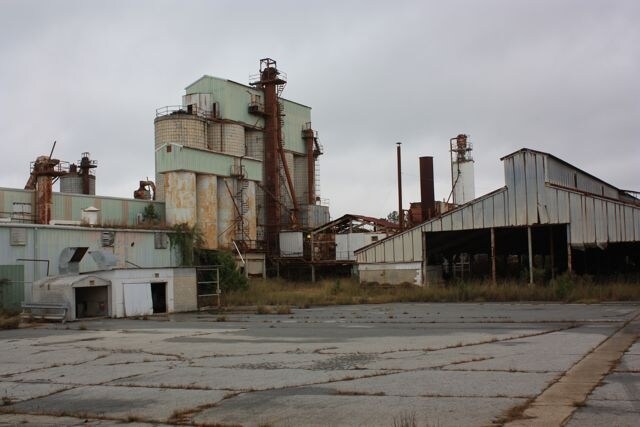
1359 Hoyt Braswell Rd
Warehouse
10.30 AC S OF WRENS O
X
Jefferson
13163C0135C
Georgia
2025
10.30 AC
2025
Georgia South Area
960100
Other Market Areas
40,000 SF
0085-020
DEMOGRAPHICS near 1359 Hoyt Braswell Rd
1 Mile
3 Mile
5 Mile
2024 Total Population
331
3,073
5,047
2029 Population
324
3,004
4,935
Pop Growth 2024-2029
(2.11%)
(2.25%)
(2.22%)
Average Age
41
42
42
2024 Total Households
131
1,253
2,027
HH Growth 2024-2029
(2.29%)
(2.08%)
(2.07%)
Median Household Inc
$35,263
$39,479
$42,994
Avg Household Size
2.40
2.40
2.50
2024 Avg HH Vehicles
2.00
2.00
2.00
Median Home Value
$118,518
$130,756
$123,836
Median Year Built
1989
1975
1979
Nearby Places
Map Layers
Map Styles
 Street
 Aerial
- Restaurants
- Banks
- Shops
- Fitness
- Groceries
PUBLIC TRANSPORTATION
AIRPORT
Augusta Regional at Bush Field
DRIVE
WALK
Distance
Augusta Regional at Bush Field
53 min
34.7 mi
Freight Ports
Georgia Ports - Savannah
DRIVE
WALK
Distance
Georgia Ports - Savannah
159 min
118.1 mi
Nearby Properties
Address
Land Use
TOTAL SIZE
Lot Size
Zoning
Address
Land Use
TOTAL SIZE
Lot Size
Zoning
82,283 SF
12.36 AC
R2
Address
Land Use
TOTAL SIZE
Lot Size
Zoning
191,633 SF
15 AC
C
Address
Land Use
TOTAL SIZE
Lot Size
Zoning
960 SF
5.25 AC
I2
Address
Land Use
TOTAL SIZE
Lot Size
Zoning
44,124 SF
9.10 AC
C
Address
Land Use
TOTAL SIZE
Lot Size
Zoning
22,488 SF
26.58 AC
RA
Address
Land Use
TOTAL SIZE
Lot Size
Zoning
11,400 SF
5 AC
I-1
Address
Land Use
TOTAL SIZE
Lot Size
Zoning
59,248 SF
5.24 AC
I2
Address
Land Use
TOTAL SIZE
Lot Size
Zoning
11.52 AC
C
Address
Land Use
TOTAL SIZE
Lot Size
Zoning
12,520 SF
1.76 AC
C
Address
Land Use
TOTAL SIZE
Lot Size
Zoning
35,300 SF
102.91 AC
M1/M2
Address
Land Use
TOTAL SIZE
Lot Size
Zoning
444.32 AC
M1/M2
Address
Land Use
TOTAL SIZE
Lot Size
Zoning
20,000 SF
20.12 AC
M1/M2
Address
Land Use
TOTAL SIZE
Lot Size
Zoning
2,292 SF
13.89 AC
I1
Address
Land Use
TOTAL SIZE
Lot Size
Zoning
20,392 SF
1.94 AC
C
Address
Land Use
TOTAL SIZE
Lot Size
Zoning
6,000 SF
7.74 AC
R1
Address
Land Use
TOTAL SIZE
Lot Size
Zoning
2,497 SF
406.52 AC
RA
Address
Land Use
TOTAL SIZE
Lot Size
Zoning
350.90 AC
RA
Address
Land Use
TOTAL SIZE
Lot Size
Zoning
897 SF
7.01 AC
R2
Address
Land Use
TOTAL SIZE
Lot Size
Zoning
16,625 SF
2.95 AC
C
Address
Land Use
TOTAL SIZE
Lot Size
Zoning
2,997 SF
2.84 AC
R2
Address
Land Use
TOTAL SIZE
Lot Size
Zoning
28,915 SF
3.09 AC
C
Address
Land Use
TOTAL SIZE
Lot Size
Zoning
60,156 SF
10.86 AC
I2
Address
Land Use
TOTAL SIZE
Lot Size
Zoning
479.52 AC
RA
Address
Land Use
TOTAL SIZE
Lot Size
Zoning
10,598 SF
3.07 AC
C
Address
Land Use
TOTAL SIZE
Lot Size
Zoning
786 SF
3 AC
R2
Address
Land Use
TOTAL SIZE
Lot Size
Zoning
9,000 SF
0.87 AC
C
Address
Land Use
TOTAL SIZE
Lot Size
Zoning
2,760 SF
10.59 AC
RA
Address
Land Use
TOTAL SIZE
Lot Size
Zoning
2,550 SF
36.36 AC
A1A, I2
Address
Land Use
TOTAL SIZE
Lot Size
Zoning
6,960 SF
0.53 AC
C
The World's #1 Commercial Real Estate Marketplace
Connect with us
© 2025 CoStar Group
The information above has been obtained from sources believed reliable. While we do not doubt its accuracy we have not verified it and make no guarantee, warranty or representation about it. It is your responsibility to independently confirm its accuracy and completeness. Any projections, opinions, assumptions, or estimates used are for example only and do not represent the current or future performance of the property. The value of this transaction to you depends on tax and other factors which should be evaluated by your tax, financial, and legal advisors. You and your advisors should conduct a careful, independent investigation of the property to determine to your satisfaction the suitability of the property for your needs.